| During the month of April, Mark Miller will donate $75 to the charity of your choice (5 to chose from, including the Utah Avalanche Center!) Mark Miller Subaru has raised over $300k in the previous 6 Do Good Feel Good events. More Info here |  |
| During the month of April, Mark Miller will donate $75 to the charity of your choice (5 to chose from, including the Utah Avalanche Center!) Mark Miller Subaru has raised over $300k in the previous 6 Do Good Feel Good events. More Info here | |
| Advisory: Uintas Area Mountains | Issued by Craig Gordon for Wednesday - January 14, 2015 - 5:59am |
|---|

|
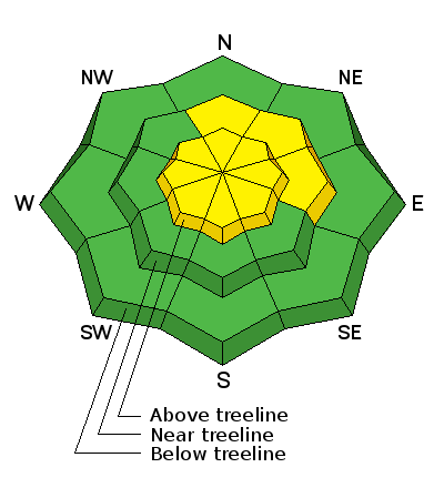
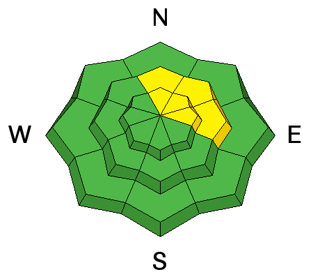
bottom line Today you'll find pockets MODERATE avalanche danger on steep, rocky, mid and upper elevation slopes, especially those with recent deposits of wind drifted snow and human triggered avalanches are possible. While not widespread and making up a small portion of the terrain available to ride in, once triggered, avalanches still have potential to break to weak layers near the ground, especially on slopes facing North, Northeast, and East. All other terrain offers a LOW avalanche danger.
|
 |
special announcement We still have a slots open. For more info and to register click HERE.
We just released an exciting, new avy safety video designed specifically for snowmobilers - Knowledge is Powder. https://vimeo.com/113677686 NEW THIS YEAR: You can now receive advisories by email for each region in the state. Go here for details. |
 |
current conditions In the wake of Monday's storm, skies began clearing late yesterday and temperatures dipped into the teens overnight. East and Northeast winds blew in the 20's and 30's along the high ridges for most of Tuesday, but backed off early this morning and are now in the 15-20 mph range. The storm was good to the eastern front with an evenly distributed 15" of snow across the range. Yesterday, the riding and turning conditions were deep and surfy. However, the sun is getting stronger and we found damp snow on low elevation terrain and slopes facing the south half of the compass. Click here for real-time temperatures, snowfall, and winds.
A thick coat of white paint blanketed the range.
|
 |
recent activity We noted small sluffs and a couple of shallow soft slabs within the storm snow.... otherwise no news of the weird. |
| type | aspect/elevation | characteristics |
|---|

|
|
LIKELIHOOD
 LIKELY
UNLIKELY
SIZE
 LARGE
SMALL
TREND
 INCREASING DANGER
SAME
DECREASING DANGER
|
|
description
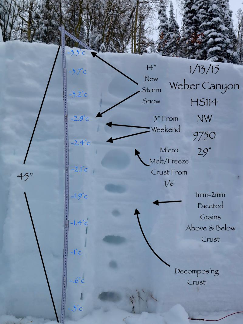
The Uinta's are white and the range got pounded by Monday's storm. Fortunately, we didn't experience the big, screaming, pre-frontal south winds usually accompanying a big storm and that's good news. While most areas across the range adjusted to the additional load, it's not a totally straightforward, no brainer kinda day, and there's two variables factoring into the avalanche hazard. First, the sun is getting more intense and temperatures are expected to rise. As the new storm snow settles, it becomes more of a slab, and this change could help wake up some of the layers buried in the mid portion of our snowpack. Second, we've got a lot of terrain that avalanched during the Solstice storm and the snowpack is weak and shallow. Prime suspects are slopes facing North, Northeast, and East at mid and upper elevations. In either case, once a slide is triggered, today's avalanches have the potential to break deeper than you might expect.
JG's pit brilliantly shows the weak sugary snow developing above and below the midpack crust. This is the layer where avalanches have the potential to break to the next couple days.
|
| type | aspect/elevation | characteristics |
|---|

|

|
LIKELIHOOD
LIKELY
UNLIKELY
SIZE
 LARGE
SMALL
TREND
 INCREASING DANGER
SAME
DECREASING DANGER
|
|
description
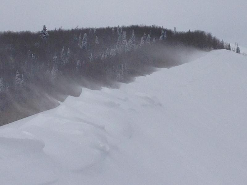
Yesterday's unusual East and Northeast wind direction deposited snow on slopes with a westerly component to their aspect. While mostly manageable in size and depth, if you're in steep, committing terrain, even a small slide can knock you off your feet or roll your machine.
There's plenty of fresh snow available to blow around.
Pretty easy to detect by their fat, rounded appearance, today you'll want to avoid steep slopes with recent wind drifts. |
 |
weather High pressure builds over the region and we'll see sunny skies, warming temperatures, and decreasing winds. High temperatures reach into the mid 20's with overnight lows in the teens. Northerly winds remain in the 20's and 30's along the highest peaks and continue to decrease throughout the end of the week. A weak storm grazes the area late in the week with a few clouds and light snow possible. |
| general announcements Remember your information can save lives. If you see anything we should know about, please participate in the creation of our own community avalanche advisory by submitting snow and avalanche conditions. You can call me directly at 801-231-2170, email [email protected], or email by clicking HERE This is a great time of year to schedule a free avalanche awareness presentation for your group or club. You can contact me at 801-231-2170 or email [email protected] Donate to your favorite non-profit –The Utah Avalanche Center. The UAC depends on contributions from users like you to support our work. Benefit the Utah Avalanche Center when you buy or sell on ebay - set the Utah Avalanche Center as a favorite non-profit in your ebay account here and click on ebay gives when you buy or sell. You can choose to have your seller fees donated to the UAC, which doesn't cost you a penny. Utah Avalanche Center mobile app - Get your advisory on your iPhone along with great navigation and rescue tools. The information in this advisory is from the US Forest Service which is solely responsible for its content. This advisory describes general avalanche conditions and local variations always occur. I will update this advisory by 7:00 AM Saturday Jan. 17, 2015. |


_0.jpg)