| During the month of April, Mark Miller will donate $75 to the charity of your choice (5 to chose from, including the Utah Avalanche Center!) Mark Miller Subaru has raised over $300k in the previous 6 Do Good Feel Good events. More Info here |  |
| During the month of April, Mark Miller will donate $75 to the charity of your choice (5 to chose from, including the Utah Avalanche Center!) Mark Miller Subaru has raised over $300k in the previous 6 Do Good Feel Good events. More Info here | |
| Advisory: Uintas Area Mountains | Issued by Craig Gordon for Wednesday - December 31, 2014 - 6:17am |
|---|

|
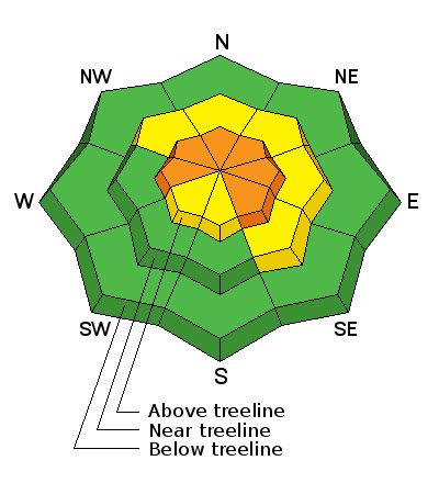
bottom line While not widespread and making up a small portion of the terrain available to ride in, today you'll find pockets of CONSIDERABLE avalanche danger and human triggered slides are probable on upper elevation, wind drifted slopes. Any slide triggered today has the potential to break to the ground, resulting in a dangerous avalanche. A MODERATE avalanche danger exists on recently wind loaded slopes at mid elevations and human triggered avalanches are possible A LOW avalanche danger exists on low and mid elevation slopes facing the south half of the compass and terrain that had no pre-existing snow prior to the big Christmas storm cycle.
|
 |
special announcement
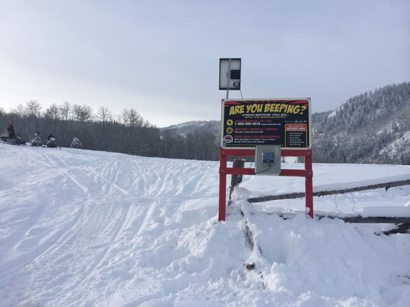
Finally there's enough snow to start getting our beacon checkers installed. Thanks to our most excellent intern Bo Torrey for helping get the Nobletts unit sunk in the snow yesterday. We just released an exciting, new avy safety video designed specifically for snowmobilers - Knowledge is Powder. https://vimeo.com/113677686 NEW THIS YEAR: You can now receive advisories by email for each region in the state. Go here for details.
|
 |
current conditions Hope you remembered to plug the block heater in last night. This morning's temperatures in the -10 to -25 degree range are both diesel as well plasma gelling. Add an east wind blowing 10-20 mph along the high ridges and wind chill factors are in the -30 degree range. Snow surface conditions in the high terrain are a bit wind patted, but lose a little elevation, get into some wind sheltered terrain, and the snow is cold, deep, and light.
|
 |
recent activity
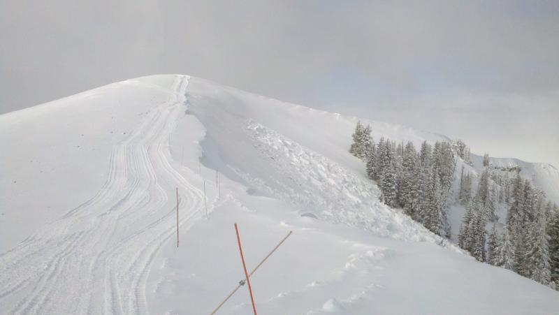
This slide in Upper Weber Canyon, was triggered from a distance, breaking deep and wide to weak layers of snow near the ground.
|
| type | aspect/elevation | characteristics |
|---|

|
|
LIKELIHOOD
 LIKELY
UNLIKELY
SIZE
 LARGE
SMALL
TREND
 INCREASING DANGER
SAME
DECREASING DANGER
|
|
description
We're dealing with two avalanche issues today, but I'm going to roll them into one package for simplicities sake. First, a few fresh drifts formed on westerly facing slopes along the high ridges as a result of the recent east wind event. Mostly manageable in size and depth, and breaking at or below your skis, board, or sled, these are easy to detect by their rounded appearance. Second, the snowpack appears to be adjusting to the big pre-Christmas storm and I think the chances of triggering an avalanche that breaks to deeper buried weak layers in the snowpack is becoming less likely overtime. However, given the snow structure, along with the consequences of triggering a slide, the avalanche hazard remains in the low probability/high consequence category. You probably wouldn't bet the house at a Vegas blackjack table with these odds and I don't think I'd take those chances on the snow. Most savvy folks I know are sticking with low angle shady slopes or working on their tans, while shredding steeper terrain facing the south half of the compass where the surface snow is still cold and light and the avalanche danger more predictable. Here's a great video illustrating the kind of avalanche dragon we're dealing with.
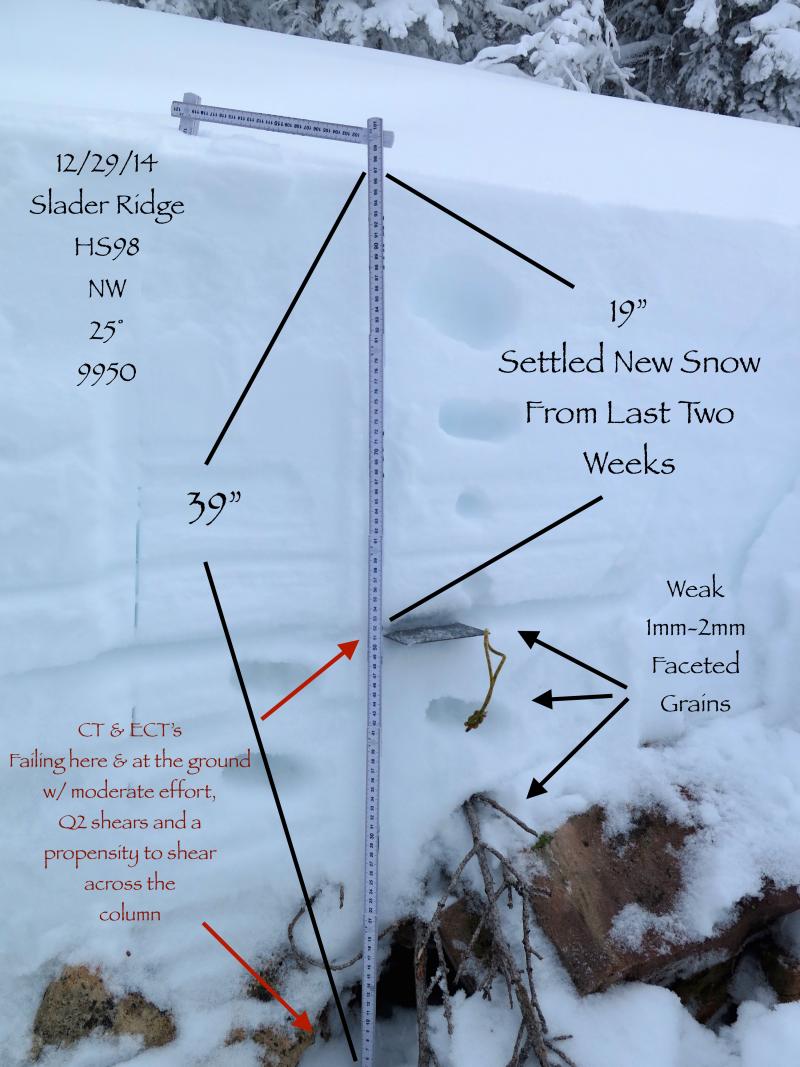
JG's snowpit tests show the snowpack is starting to heal.
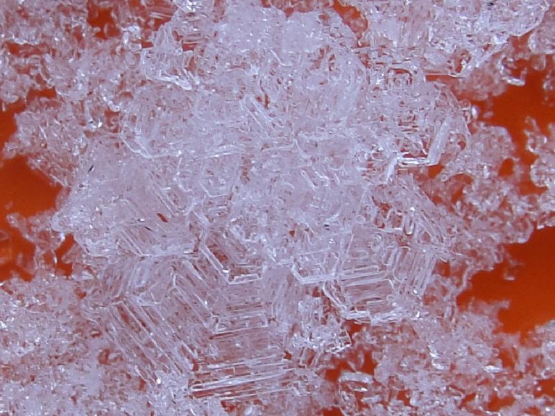
But Micheal's closeup pic, reveals it's still gonna take some time for our problem child, faceted snow near the ground, to start turning to corner towards stable snow.
|
 |
weather Clear and cold with highs only reaching into the single digits. East winds blow in the 20's along the high ridges and overnight lows near -10 degrees ring in the New Year. A slow warming trend and sunny skies are on tap for Thursday and Friday. A weak system passing to the north brings the chance of a little light snow Friday night into Saturday with dry and warmer conditions Sunday. |
| general announcements Remember your information can save lives. If you see anything we should know about, please participate in the creation of our own community avalanche advisory by submitting snow and avalanche conditions. You can call me directly at 801-231-2170, email [email protected], or email by clicking HERE This is a great time of year to schedule a free avalanche awareness presentation for your group or club. You can contact me at 801-231-2170 or email [email protected] Donate to your favorite non-profit –The Utah Avalanche Center. The UAC depends on contributions from users like you to support our work. Benefit the Utah Avalanche Center when you buy or sell on ebay - set the Utah Avalanche Center as a favorite non-profit in your ebay account here and click on ebay gives when you buy or sell. You can choose to have your seller fees donated to the UAC, which doesn't cost you a penny. Utah Avalanche Center mobile app - Get your advisory on your iPhone along with great navigation and rescue tools. The information in this advisory is from the US Forest Service which is solely responsible for its content. This advisory describes general avalanche conditions and local variations always occur. I will update this advisory by 7:00 AM Saturday Jan. 3, 2015. |


_0.jpg)