| During the month of April, Mark Miller will donate $75 to the charity of your choice (5 to chose from, including the Utah Avalanche Center!) Mark Miller Subaru has raised over $300k in the previous 6 Do Good Feel Good events. More Info here |  |

For every car Mark MIller Subaru sells in April, they will donate $75 to the charity of your choice (5 to choose from). Who are you going to choose? Plus - you can vote for your favorite and the 3 groups receiving the most votes get an additional cash prize donated by Mark Miller Subaru. Details here

| During the month of April, Mark Miller will donate $75 to the charity of your choice (5 to chose from, including the Utah Avalanche Center!) Mark Miller Subaru has raised over $300k in the previous 6 Do Good Feel Good events. More Info here |  |
| Advisory: Uintas Area Mountains | Issued by Craig Gordon for Friday - December 26, 2014 - 5:39am |
|---|
 |
special announcement We just released an exciting, new avy safety video designed specifically for snowmobilers - Knowledge is Powder. https://vimeo.com/113677686 NEW THIS YEAR: You can now receive advisories by email for each region in the state. Go here for details.
|
 |
current conditions Winds relaxed, temperatures dropped, and snow fell straight out of the sky yesterday, stacking up an additional foot of light density fluff in the past 24 hrs. North and northeast winds increased around 2:00 this morning and are currently blowing 15-30 mph along the high peaks. Temperatures are near zero. The coverage has gone from zero to hero and it's an over-the-head and over-the-hood kinda day. Excellent riding and turning conditions are found, especially on mid elevation, wind sheltered slopes.
|
 |
recent activity A couple sled triggered slides near Tower Mountain on Tuesday occurring on heavily wind loaded east and northeast facing terrain. Fortunately, the debris fanned out and no one was caught, buried, or injured, but the writing is on the wall and avalanche conditions remain sketchy in the western Uinta's. Recent trip reports, backcountry observations, and avalanche observations are found here.
|
| type | aspect/elevation | characteristics |
|---|


|


|

LIKELIHOOD
 LIKELY
UNLIKELY
SIZE
 LARGE
SMALL
TREND
 INCREASING DANGER
SAME
DECREASING DANGER
|
|
description
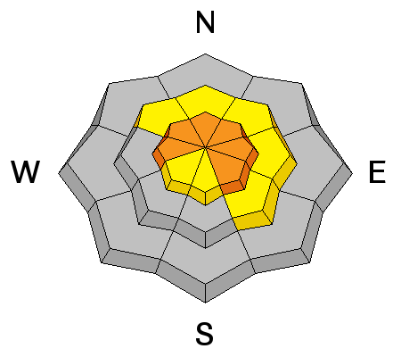
Just a little bump in the winds created fresh drifts, sensitive to the weight of a rider. Fat and rounded in their appearance, these soft slabs formed on upper elevation, leeward slopes facing the north half of the compass. In addition, due to the easterly winds, I suspect you'll find drifting on slopes with a west component to their aspect as well. While mostly manageable in size and depth, today's new snow slabs will be sensitive to the additional weight of a rider. Remember- shooting cracks in front of your skis, board, or sled are huge clues to unstable snow. And don't forget the biggest clue... recent avalanches! Especially if they're occurring on the same kind of slope you wanna ride on.
|
| type | aspect/elevation | characteristics |
|---|


|


|

LIKELIHOOD
 LIKELY
UNLIKELY
SIZE
 LARGE
SMALL
TREND
 INCREASING DANGER
SAME
DECREASING DANGER
|
|
description
More deceptive, not so easy to detect, and even less manageable are avalanches that break to weak layers of snow near the ground. It's what we call deep slabs. Here's a great video illustrating why they're so dangerous. Any avalanche triggered today has the potential to break into weak layers near the ground, producing a large and dangerous slide. Avoid steep wind drifted terrain and you avoid the problem Unpredictable, dangerous, and triggered on relatively low angle terrain, this recent slide on the Roundy Basin Ridge broke to weak snow near the ground. |
 |
weather The storm is winding down and skies should begin to clear as the day progresses. North and northeast winds will be a nuisance along the high peaks, gusting into the 30's and 40's, but relaxing throughout the day. High temperatures barely reach the low teens and dive to -10 overnight. Clear and warmer for Saturday. Next storm system impacts the area by Sunday morning with bulk of storm continuing into Monday. |
| general announcements Remember your information can save lives. If you see anything we should know about, please participate in the creation of our own community avalanche advisory by submitting snow and avalanche conditions. You can call me directly at 801-231-2170, email [email protected], or email by clicking HERE This is a great time of year to schedule a free avalanche awareness presentation for your group or club. You can contact me at 801-231-2170 or email [email protected] Donate to your favorite non-profit –The Utah Avalanche Center. The UAC depends on contributions from users like you to support our work. Benefit the Utah Avalanche Center when you buy or sell on ebay - set the Utah Avalanche Center as a favorite non-profit in your ebay account here and click on ebay gives when you buy or sell. You can choose to have your seller fees donated to the UAC, which doesn't cost you a penny. Utah Avalanche Center mobile app - Get your advisory on your iPhone along with great navigation and rescue tools. The information in this advisory is from the US Forest Service which is solely responsible for its content. This advisory describes general avalanche conditions and local variations always occur. I will update this advisory by 7:00 AM Saturday Dec. 27, 2014. |
Advisory Hotline: (888) 999-4019 | Contact Information