| During the month of April, Mark Miller will donate $75 to the charity of your choice (5 to chose from, including the Utah Avalanche Center!) Mark Miller Subaru has raised over $300k in the previous 6 Do Good Feel Good events. More Info here |  |
| During the month of April, Mark Miller will donate $75 to the charity of your choice (5 to chose from, including the Utah Avalanche Center!) Mark Miller Subaru has raised over $300k in the previous 6 Do Good Feel Good events. More Info here | |
| Advisory: Uintas Area Mountains | Issued by Craig Gordon for Sunday - April 6, 2014 - 5:47am |
|---|


|
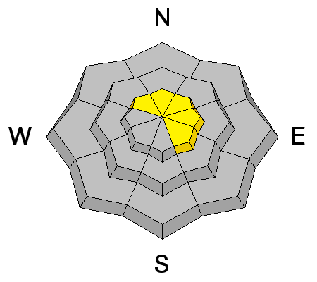
bottom line At upper elevations in the wind zone, a MODERATE avalanche danger exists and human triggered avalanches are possible in steep, sustained, wind drifted terrain facing the north half of the compass. While not widespread, there's still an isolated possibility that today's avalanches can break deeper and wider than you might expect, particularly in steep, rocky terrain. Out of the wind and in mid and low elevation terrain the avalanche danger is generally LOW.
.
|
 |
special announcement Sunday April 13th will be the last of our regularly scheduled advisories for the 2013-14 season. |
 |
current conditions Yesterday's little storm produced 2" of snow, helping to keep the dream alive on mid and high elevation shady slopes. This morning, skies are mostly cloudy and temperatures are in the teens and low 20's. West-northwest winds ramped up sightly late yesterday afternoon and are currently blowing in the 20's and 30's along the high ridges.
Ted and I took the monster trucks out for a spin in Superbowl and felt confident with our terrain choices knowing this slope slid to the ground in mid February. Click here for current winds, temperatures, and snowfall throughout the range. Click here for trip reports.
|
 |
recent activity No news of the weird to report. Archived avalanche activity is found here.
|
| type | aspect/elevation | characteristics |
|---|

|
|
LIKELIHOOD
 LIKELY
UNLIKELY
SIZE
 LARGE
SMALL
TREND
 INCREASING DANGER
SAME
DECREASING DANGER
|
|
description
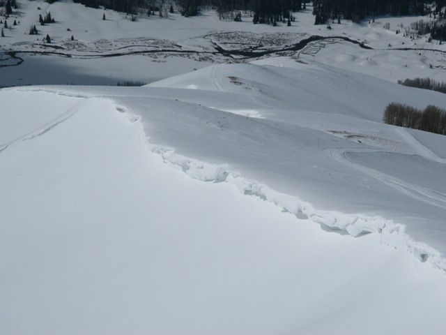
Winds found enough snow late yesterday to form shallow slabs along the leeward side of upper elevation ridges. Ridgetop winds are forecast to increase throughout the day, and they'll whip up yet a whole new batch of slabs. While mostly predictable in depth and width, if your travels take you into steep, technical, no mistake kinda terrain, remember that even a small slide can have major consequences if you get carried over a cliff or slammed into a tree. If you're getting after it today, gather some information on small test slopes and see how they're reacting before charging into big, committing terrain.
.
|
| type | aspect/elevation | characteristics |
|---|

|
|
LIKELIHOOD
LIKELY
UNLIKELY
SIZE
 LARGE
SMALL
TREND
 INCREASING DANGER
SAME
DECREASING DANGER
|
|
description
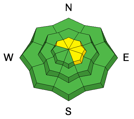
I'm not convinced that somewhere in a range as vast as the western Uinta's, you couldn't find an avalanche that breaks to weak snow near the ground. While there's plenty of slopes offering green light conditions, steep, rocky terrain, facing the north half of the compass remains suspect. Unless you have a detailed history of the slope you plan to ride and know it's avalanched to the ground at some point this season, given the consequences, it's best to avoid terrain with these characteristics. |
| type | aspect/elevation | characteristics |
|---|

|

|
LIKELIHOOD
 LIKELY
UNLIKELY
SIZE
LARGE
SMALL
TREND
INCREASING DANGER
SAME
DECREASING DANGER
|
|
description
Strong winds have produced large cornices that may break back further than you might expect. Probably best to avoid being on or under these unpredictable monsters. |
 |
weather A weak storm dives through the region today, giving us mostly cloudy skies and a slight chance for a few inches of snow. West and northwest winds ramp up throughout the day, averaging in the 30's and 40's with a few gusts cranking into the 60's along the high peaks. Temperatures climb into the low 30's and dip into the teens overnight. Winds mellow tonight as high pressure moves over the region. Sunny skies and temperatures warming to well above average are on tap for Monday through Wednesday. There's a hint at storminess for next weekend.
|
| general announcements Remember your information can save lives. If you see anything we should know about, please participate in the creation of our own community avalanche advisory by submitting snow and avalanche conditions. You can call me directly at 801-231-2170, email [email protected], or email by clicking HERE This is a great time of year to schedule a free avalanche awareness presentation for your group or club. You can contact me at 801-231-2170 or email [email protected] Donate to your favorite non-profit –The Utah Avalanche Center. The UAC depends on contributions from users like you to support our work. Benefit the Utah Avalanche Center when you buy or sell on ebay - set the Utah Avalanche Center as a favorite non-profit in your ebay account here and click on ebay gives when you buy or sell. You can choose to have your seller fees donated to the UAC, which doesn't cost you a penny. Utah Avalanche Center mobile app - Get your advisory on your iPhone along with great navigation and rescue tools. The information in this advisory is from the US Forest Service which is solely responsible for its content. This advisory describes general avalanche conditions and local variations always occur. I will update this advisory by 7:00 AM on Wednesday Apr. 9, 2014 or sooner if conditions warrant. |


_0.jpg)