| During the month of April, Mark Miller will donate $75 to the charity of your choice (5 to chose from, including the Utah Avalanche Center!) Mark Miller Subaru has raised over $300k in the previous 6 Do Good Feel Good events. More Info here |  |
| During the month of April, Mark Miller will donate $75 to the charity of your choice (5 to chose from, including the Utah Avalanche Center!) Mark Miller Subaru has raised over $300k in the previous 6 Do Good Feel Good events. More Info here | |
| Advisory: Uintas Area Mountains | Issued by Craig Gordon for Sunday - March 30, 2014 - 5:54am |
|---|

|
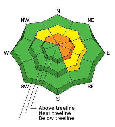
bottom line At upper elevations in the wind zone, the avalanche danger will rise to CONSIDERABLE as today's storm begins to materialize. With snow and wind in the forecast, human triggered avalanches are likely in steep, sustained, wind drifted terrain facing the north half of the compass. While not widespread, once initiated, today's avalanches can break deep and wide, particularly in steep, rocky terrain. Mid elevation terrain terrain offers MODERATE avalanche danger and human triggered avalanches are possible on steep, wind drifted slopes. Low elevation, wind sheltered terrain and slopes facing the south half of the compass offer a generally LOW avalanche danger.
.
|
 |
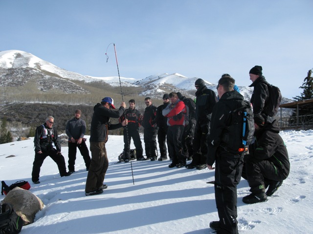
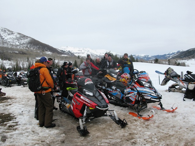
special announcement Huge thanks to everyone who helped make yesterday's Avy and Riding Skills class such a rockin' event. In particular... a huge shout out to the Park City Powdercats and ADS Motorsports for all the very generous support. In addition, many thanks to Randy Sugihara from the Alpine Assassins for giving so much of himself and his time to the sled and avalanche community. Also, I couldn't pull this off without all the help of an amazing cast of characters which includes Trent Meisenheimer, Cody Hughes, Andy VanHouten, Tyler St. Jeor, Paul Diegel, and of course, everyone who attended. Thanks for all the great support!
Rescue guru Andy VanHouten demonstrates proper probing technique at yesterday's sled avy class
Randy Sugihara displays all the rescue gear he carries on his sled. If you're ever in a bind, you definitely wanna see him roll up on the scene. |
 |
current conditions A strong cold front is at our doorstep and it should start stomping by about mid morning. In the meantime, temperatures are right around freezing and southwest winds are cranking. Since early Saturday morning winds have been averaging 30-40 mph and began ramping up over night with gusts near 70 mph along the high ridges. You'll have to seek out wind sheltered slopes for the goods today. Mid elevation north facing terrain still offers soft, settled snow. Click here for current winds, temperatures, and snowfall throughout the range. Click here for trip reports.
|
 |
recent activity
Recent winds have allowed cornices to grow and they're breaking back further than you might expect No news of the weird to report. Archived avalanche activity is found here.
|
| type | aspect/elevation | characteristics |
|---|

|

|
LIKELIHOOD
 LIKELY
UNLIKELY
SIZE
 LARGE
SMALL
TREND
 INCREASING DANGER
SAME
DECREASING DANGER
|
|
description
With strong winds and snowfall on tap, the avalanche danger will rise throughout the day. Fresh wind drifts are gonna be the most obvious avalanche problem and due to the strength of the winds, I suspect you'll find slabs a bit lower down-slope than you might expect. As the storm evolves, drifts will become more widespread and more sensitive. In addition, they'll start to break wider and deeper and pack a punch. Shooting cracks in front of your sled, skis, or board are a strong indicator to unstable snow. Slope cuts on small test slopes like road cuts give you a good barometer for the kind of avalanche dragon you're dealing with. Get some solid BETA by tweaking small slopes before charging into big terrain today.
.
|
| type | aspect/elevation | characteristics |
|---|

|

|
LIKELIHOOD
LIKELY
UNLIKELY
SIZE
 LARGE
SMALL
TREND
INCREASING DANGER
SAME
DECREASING DANGER
|
|
description
Each time the wind blows, we see avalanches breaking to weak snow near the ground, particularly in steep, rocky terrain with a thin, shallow snowpack. Strong ridgetop winds are forecast to continue today and with additional snow and water weight stacking up, this may be enough to again tip the scales. While there's plenty of slopes offering green light conditions, steep, rocky terrain, facing the north half of the compass remains suspect. Unless you have a detailed history of the slope you plan to ride and know it's avalanched to the ground at some point this season, given the consequences, it's best to avoid terrain with these characteristics. |
 |
weather A strong cold front crosses the region around lunchtime, bringing periods of heavy snow and isolated thunderstorms. Southwest winds howl in the 50's and 60's, before switching to the west and northwest with the arrival of the cold front. Temperatures fall throughout the day and a burst of snow should deliver 6"-10" before high pressure briefly returns on Monday, ahead of another system slated to impact the area Monday night through Wednesday.
|
| general announcements Remember your information can save lives. If you see anything we should know about, please participate in the creation of our own community avalanche advisory by submitting snow and avalanche conditions. You can call me directly at 801-231-2170, email [email protected], or email by clicking HERE This is a great time of year to schedule a free avalanche awareness presentation for your group or club. You can contact me at 801-231-2170 or email [email protected] Donate to your favorite non-profit –The Utah Avalanche Center. The UAC depends on contributions from users like you to support our work. Benefit the Utah Avalanche Center when you buy or sell on ebay - set the Utah Avalanche Center as a favorite non-profit in your ebay account here and click on ebay gives when you buy or sell. You can choose to have your seller fees donated to the UAC, which doesn't cost you a penny. Utah Avalanche Center mobile app - Get your advisory on your iPhone along with great navigation and rescue tools. The information in this advisory is from the US Forest Service which is solely responsible for its content. This advisory describes general avalanche conditions and local variations always occur. I will update this advisory by 7:00 AM on Wednesday Apr. 2, 2014 or sooner if conditions warrant. |


_0.jpg)