| During the month of April, Mark Miller will donate $75 to the charity of your choice (5 to chose from, including the Utah Avalanche Center!) Mark Miller Subaru has raised over $300k in the previous 6 Do Good Feel Good events. More Info here |  |
| During the month of April, Mark Miller will donate $75 to the charity of your choice (5 to chose from, including the Utah Avalanche Center!) Mark Miller Subaru has raised over $300k in the previous 6 Do Good Feel Good events. More Info here | |
| Advisory: Uintas Area Mountains | Issued by Craig Gordon for Saturday - March 29, 2014 - 4:46am |
|---|


|
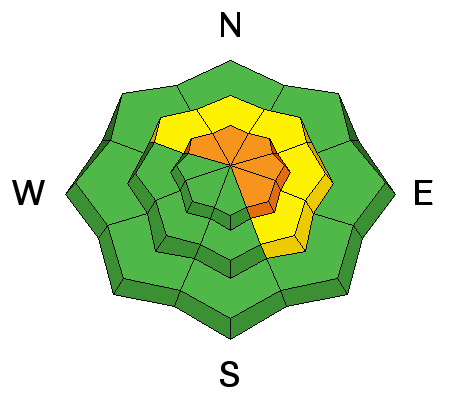
bottom line In general the avalanche danger is MODERATE and human triggered avalanches are possible on steep, wind drifted slopes. While not widespread, at upper elevations in the wind zone, pockets of CONSIDERABLE danger exist and human triggered avalanches are likely in steep, sustained, wind drifted terrain. While not widespread, once initiated, today's avalanches can break deep and wide, particularly in steep, rocky terrain. Mid and low elevation wind sheltered terrain offers a generally LOW avalanche danger.
.
|
 |
current conditions Clouds are streaming into the region this morning, ahead of an active pattern slated to settle in over the area through midweek. In the meantime, west and southwest winds are blowing 25-40 mph along the high ridges and temperatures are in the upper teens and low 20's. Thursday's storm was good to the eastern front, delivering nearly a foot of medium density snow across the range. The surface snow took on a bit of heat yesterday particularly on sunny slopes at mid and low elevations. However, gain a little elevation and switch to the shady side of the compass and you'll still find soft, settled, surfy powder today. Ted was in Whitney Basin and found similar conditions. Click here for his trip report. Click here for current winds, temperatures, and snowfall throughout the range. Click here for trip reports.
|
 |
recent activity
Avalanches breaking in the new storm snow, ran naturally yesterday in steep, sustained, wind loaded terrain. Archived avalanche activity is found here.
|
| type | aspect/elevation | characteristics |
|---|

|
|
LIKELIHOOD
 LIKELY
UNLIKELY
SIZE
 LARGE
SMALL
TREND
 INCREASING DANGER
SAME
DECREASING DANGER
|
|
description
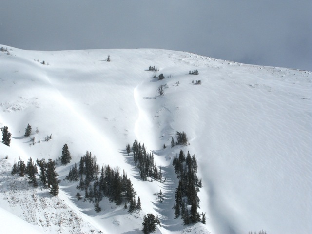
Winds cranked along the high peaks all day Thursday, lingering into the early portion of Friday morning. Gusting into the 40's and 50's, west and northwest winds found plenty of snow to blow around, easily forming fresh drifts sensitive to the additional weight of a rider. Surprisingly, soft slabs formed not only on the leeward side of ridges, but also lower down slope than you might expect and around terrain features like chutes and gullies. While generally manageable in size and depth and predictably breaking within the new storm snow, remember that if you’re getting into steep, sustained, technical terrain even a small slide could knock you off your feet or sled and take you for a nasty ride through trees or over a cliff band. Slope cuts on small test slopes like road cuts will give you a good barometer for the kind of avalanche dragon you're dealing with. Get some solid BETA by tweaking small slopes before charging into big terrain today.
Wind texturing like this can give you lots of clues. Here, the wind has been blowing left to right...
and depositing snow and forming sensitive drifts on the leeward side of gullies and chutes.
.
|
| type | aspect/elevation | characteristics |
|---|

|

|
LIKELIHOOD
LIKELY
UNLIKELY
SIZE
 LARGE
SMALL
TREND
 INCREASING DANGER
SAME
DECREASING DANGER
|
|
description
Each time the wind blows, we see avalanches breaking to weak snow near the ground, particularly in steep, rocky terrain with a thin, shallow snowpack. Strong ridgetop winds are forecast the next few days and this may be enough to again tip the scales. While there's plenty of slopes offering green light conditions, steep, rocky terrain, facing the north half of the compass remains suspect. Unless you have a detailed history of the slope you plan to ride and know it's avalanched to the ground at some point this season, given the consequences, it's best to avoid terrain with these characteristics. |
 |
weather Warm and windy today ahead of the next storm. Look for thickening clouds, temperatures rising into the low 40's, and southwest winds cranking into the 50's and 60's by about dinner time. A cold front is forecast to arrive Sunday morning and we'll see widespread snow showers with 8"-10" of snow stacking up by late in the day. A break in the action for early Monday, and then snow redevelops late Monday ahead of a storm system expected to dominate the region through mid week.
|
| general announcements Remember your information can save lives. If you see anything we should know about, please participate in the creation of our own community avalanche advisory by submitting snow and avalanche conditions. You can call me directly at 801-231-2170, email [email protected], or email by clicking HERE This is a great time of year to schedule a free avalanche awareness presentation for your group or club. You can contact me at 801-231-2170 or email [email protected] Donate to your favorite non-profit –The Utah Avalanche Center. The UAC depends on contributions from users like you to support our work. Benefit the Utah Avalanche Center when you buy or sell on ebay - set the Utah Avalanche Center as a favorite non-profit in your ebay account here and click on ebay gives when you buy or sell. You can choose to have your seller fees donated to the UAC, which doesn't cost you a penny. Utah Avalanche Center mobile app - Get your advisory on your iPhone along with great navigation and rescue tools. The information in this advisory is from the US Forest Service which is solely responsible for its content. This advisory describes general avalanche conditions and local variations always occur. I will update this advisory by 7:00 AM on Sunday Mar. 30, 2014 or sooner if conditions warrant. |


_0.jpg)