
| During the month of April, Mark Miller will donate $75 to the charity of your choice (5 to chose from, including the Utah Avalanche Center!) Mark Miller Subaru has raised over $300k in the previous 6 Do Good Feel Good events. More Info here |  |
| During the month of April, Mark Miller will donate $75 to the charity of your choice (5 to chose from, including the Utah Avalanche Center!) Mark Miller Subaru has raised over $300k in the previous 6 Do Good Feel Good events. More Info here | |
| Advisory: Uintas Area Mountains | Issued by Craig Gordon for Sunday - March 23, 2014 - 6:11am |
|---|

|
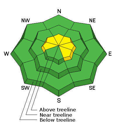
bottom line In the wind zone, a MODERATE avalanche danger exists on leeward slopes and human triggered avalanches are possible in steep, wind drifted terrain. While not widespread, once initiated, today's avalanches can break deep and wide, creating a very dangerous slide. Mid and low elevation wind sheltered terrain offers a generally LOW avalanche danger.
.
|
 |
current conditions Under clear skies, west and northwest winds are blowing 15-20 mph along the high peaks, and temperatures are in the low teens.Yesterday's quick hitting storm was a welcome surprise. It's amazing how a couple inches of new snow and bright, sunny skies can lift sprits and greatly improve the riding conditions. Soft settled snow can still be found on wind sheltered shady slopes. On the other half of the compass, smooth, creamy corn is ready for a midday harvest. Ted was in the Whitney Basin yesterday and found good riding and stable snow conditions. His trip report can be found here. Click here for current winds, temperatures, and snowfall throughout the range. Click here for trip reports.
|
 |
recent activity No recent avalanche activity to report. Archived avalanche activity is found here.
|
| type | aspect/elevation | characteristics |
|---|

|
|
LIKELIHOOD
 LIKELY
UNLIKELY
SIZE
 LARGE
SMALL
TREND
 INCREASING DANGER
SAME
DECREASING DANGER
|
|
description
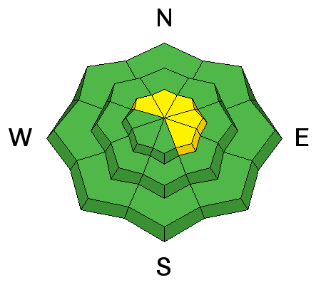
A few tired, old wind slabs may still be reactive to the additional weight of a rider today. Lurking on the leeward side of upper elevation ridges and around terrain features like chutes and gullies, these will appear fat and rounded and sound hollow like a drum. Mostly predictable in depth and width, take care that a stiff wind slab doesn't knock you off your feet, especially in steep, unforgiving, high consequence terrain.
.
|
| type | aspect/elevation | characteristics |
|---|

|
|
LIKELIHOOD
LIKELY
UNLIKELY
SIZE
 LARGE
SMALL
TREND
 INCREASING DANGER
SAME
DECREASING DANGER
|
|
description
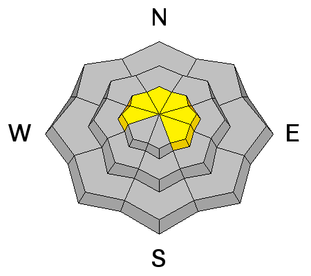
I'm not totally convinced we're done with avalanches breaking to the ground. I think at the moment the weak sugary snow near the ground is dormant and just chillin'. It usually takes a big storm or rapid load to reactivate these layers or sometimes all we need to do if find the weakest link in the snowpack, tickle it just right, and now we've triggered a monster slide. While there's plenty of slopes offering green light conditions, steep, rocky terrain, facing the north half of the compass remains suspect. Unless you have a detailed history of the slope you plan to ride and know it's avalanched to the ground at some point this season, given the consequences, it's best to avoid terrain with these characteristics.
This is the kind of terrain where you could still trigger a deep, scary avalanche. While the middle of the slope has a deep, strong snowpack, it's connected to weak snow around bushes and rocks poking out. Chances of triggering a deep slide are diminishing, but consequences remain quite severe. |
 |
weather It'll be a spectacular day in the mountains, with sunny skies and temperatures climbing into the mid 30's. Westerly winds shouldn't be much of an issue, remaining in the 10-20 mph range throughout the day. A gradual warming trend takes place through Monday and then a southwest flow develops Tuesday, ushering in much warmer air ahead of the next storm system slated to arrive on Wednesday. Looks like a decent shot of snow for late Wednesday into Thursday and then high pressure builds for next weekend.
|
| general announcements Remember your information can save lives. If you see anything we should know about, please participate in the creation of our own community avalanche advisory by submitting snow and avalanche conditions. You can call me directly at 801-231-2170, email [email protected], or email by clicking HERE This is a great time of year to schedule a free avalanche awareness presentation for your group or club. You can contact me at 801-231-2170 or email [email protected] Donate to your favorite non-profit –The Utah Avalanche Center. The UAC depends on contributions from users like you to support our work. Benefit the Utah Avalanche Center when you buy or sell on ebay - set the Utah Avalanche Center as a favorite non-profit in your ebay account here and click on ebay gives when you buy or sell. You can choose to have your seller fees donated to the UAC, which doesn't cost you a penny. Utah Avalanche Center mobile app - Get your advisory on your iPhone along with great navigation and rescue tools. The information in this advisory is from the US Forest Service which is solely responsible for its content. This advisory describes general avalanche conditions and local variations always occur. I will update this advisory by 7:00 AM on Wednesday Mar. 26, 2014 or sooner if conditions warrant. |


_0.jpg)
