| During the month of April, Mark Miller will donate $75 to the charity of your choice (5 to chose from, including the Utah Avalanche Center!) Mark Miller Subaru has raised over $300k in the previous 6 Do Good Feel Good events. More Info here |  |

For every car Mark MIller Subaru sells in April, they will donate $75 to the charity of your choice (5 to choose from). Who are you going to choose? Plus - you can vote for your favorite and the 3 groups receiving the most votes get an additional cash prize donated by Mark Miller Subaru. Details here

| During the month of April, Mark Miller will donate $75 to the charity of your choice (5 to chose from, including the Utah Avalanche Center!) Mark Miller Subaru has raised over $300k in the previous 6 Do Good Feel Good events. More Info here |  |
| Advisory: Uintas Area Mountains | Issued by Craig Gordon for Saturday - March 22, 2014 - 5:35am |
|---|
 |
current conditions A weak storm system sliding to the north of the region is ushering in high, thin clouds, but nothing on the way of precip. West and southwest winds are blowing 20-30 mph along the high peaks and temperatures are in the upper teens and mid 20's. The snow surface has taken a hard hit this week and soft snow is limited to very sheltered, shady terrain. The south half of the compass is starting to offer corn-like conditions, particularly at mid and lower elevations. Might be a good day to crank out the taxes. Click here for current winds, temperatures, and snowfall throughout the range. Click here for trip reports.
|
 |
recent activity No recent avalanche activity to report. Archived avalanche activity is found here.
|
| type | aspect/elevation | characteristics |
|---|


|


|

LIKELIHOOD
 LIKELY
UNLIKELY
SIZE
 LARGE
SMALL
TREND
 INCREASING DANGER
SAME
DECREASING DANGER
|
|
description
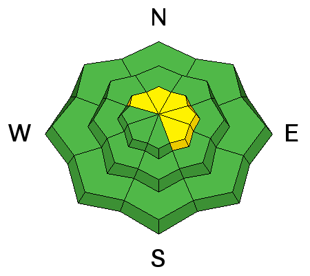
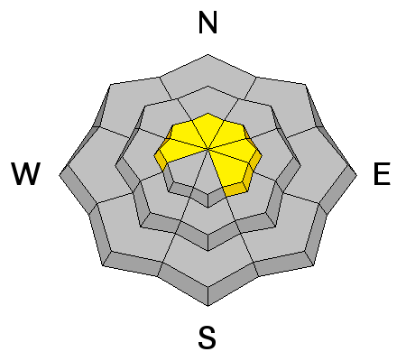
A few tired, old wind slabs may still be reactive to the additional weight of a rider today. Lurking on the leeward side of upper elevation ridges and around terrain features like chutes and gullies, these will appear fat and rounded and sound hollow like a drum. Mostly predictable in depth and width, take care that a stiff wind slab doesn't knock you off your feet, especially in steep, unforgiving, high consequence terrain.
.
|
| type | aspect/elevation | characteristics |
|---|


|


|

LIKELIHOOD
 LIKELY
UNLIKELY
SIZE
 LARGE
SMALL
TREND
 INCREASING DANGER
SAME
DECREASING DANGER
|
|
description
I'm not totally convinced we're done with avalanches breaking to the ground. I think at the moment the weak sugary snow near the ground is dormant and just chillin'. It usually takes a big storm or rapid load to reactivate these layers or sometimes all we need to do if find the weakest link in the snowpack, tickle it just right, and now we've triggered a monster slide. While there's plenty of slopes offering green light conditions, steep, rocky terrain, facing the north half of the compass remains suspect. Unless you have a detailed history of the slope you plan to ride and know it's avalanched to the ground at some point this season, given the consequences, it's best to avoid terrain with these characteristics. |
 |
weather This morning we can expect overcast skies a couple of flurries with west and northwest winds averaging 15-25 mph along the high ridges. Skies clear as the day progresses and high temperatures reach into the low 30's. Under clear skies, overnight lows dip into the teens. High pressure builds for early in the week giving us warm, dry weather and then a quick hitting storm is shaping up for Wednesday.
|
| general announcements Remember your information can save lives. If you see anything we should know about, please participate in the creation of our own community avalanche advisory by submitting snow and avalanche conditions. You can call me directly at 801-231-2170, email [email protected], or email by clicking HERE This is a great time of year to schedule a free avalanche awareness presentation for your group or club. You can contact me at 801-231-2170 or email [email protected] Donate to your favorite non-profit –The Utah Avalanche Center. The UAC depends on contributions from users like you to support our work. Benefit the Utah Avalanche Center when you buy or sell on ebay - set the Utah Avalanche Center as a favorite non-profit in your ebay account here and click on ebay gives when you buy or sell. You can choose to have your seller fees donated to the UAC, which doesn't cost you a penny. Utah Avalanche Center mobile app - Get your advisory on your iPhone along with great navigation and rescue tools. The information in this advisory is from the US Forest Service which is solely responsible for its content. This advisory describes general avalanche conditions and local variations always occur. I will update this advisory by 7:00 AM on Sunday Mar. 23, 2014 or sooner if conditions warrant. |
Advisory Hotline: (888) 999-4019 | Contact Information