| During the month of April, Mark Miller will donate $75 to the charity of your choice (5 to chose from, including the Utah Avalanche Center!) Mark Miller Subaru has raised over $300k in the previous 6 Do Good Feel Good events. More Info here |  |
| During the month of April, Mark Miller will donate $75 to the charity of your choice (5 to chose from, including the Utah Avalanche Center!) Mark Miller Subaru has raised over $300k in the previous 6 Do Good Feel Good events. More Info here | |
| Advisory: Uintas Area Mountains | Issued by Craig Gordon for Wednesday - March 12, 2014 - 5:58am |
|---|

|
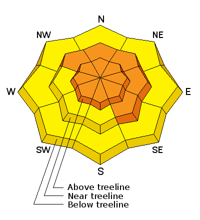
bottom line At and above treeline in the wind zone, a CONSIDERABLE avalanche danger exists and human triggered avalanches are probable on all steep, wind drifted slopes, particularly those facing the north half of the compass. Once triggered, today's avalanches can break deep and wide, creating a very dangerous slide. The danger of wet avalanche activity will rise to MODERATE during the heat of the day and human triggered avalanches will become possible on steep sun exposed slopes as the day wares on.
.
|
 |
current conditions Monday's storm delivered a good shot o snow for the eastern front, with the bulk of the moisture focusing on the North Slope where nearly a foot of snow has stacked up. Skies cleared out late yesterday and temperatures are in the single digits. As the storm dives to the four corners, east and north east winds developed along the high ridges and they've blowing 20-30 mph since about midnight. Riding and turning conditions are outstanding on a go anywhere kinda base. Click here for current winds, temperatures, and snowfall throughout the range. Click here for trip reports and avalanche observations.
|
 |
recent activity
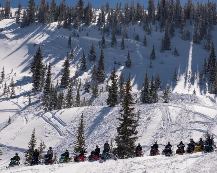
A group of riders pay their respects at the Gold Hill avalanche accident. Our investigation can be found here More avalanche activity is found here.
|
| type | aspect/elevation | characteristics |
|---|

|
|
LIKELIHOOD
 LIKELY
UNLIKELY
SIZE
 LARGE
SMALL
TREND
 INCREASING DANGER
SAME
DECREASING DANGER
|
|
description
It's no mystery that the western Uinta's have been sketchy since the early January storm cycle, but it's remarkable how long the instability has lingered. This isn't the kind of scary that lasts a few days and then we're good to go. This is the kind of scary that lingers for weeks and is extremely hard to manage because avalanches are breaking so historically deep and wide. In addition, it's a condition we're not used to seeing this late in the season. Steep, rocky terrain facing the north half of the compass is our problem child. The only way to manage unmanageable avalanches that break to the ground is with your terrain choices. It's easy... simply avoid being on or underneath slopes with these type of characteristics. This viddy helps explain what's going.
.
|
| type | aspect/elevation | characteristics |
|---|

|
|
LIKELIHOOD
 LIKELY
UNLIKELY
SIZE
 LARGE
SMALL
TREND
INCREASING DANGER
SAME
DECREASING DANGER
|
|
description
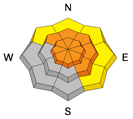
Winds were over the place during the storm and now they're from an easterly direction, loading slopes with a westerly component to their aspect, which is unusual for us. While mostly confined to upper elevation terrain, today you'll want to avoid any fat looking, rounded piece of snow, especially if it sounds hollow like a drum. Once triggered, a fresh wind drift could get quickly out of hand if it breaks into weak, old snow buried deep in the snowpack.
|
| type | aspect/elevation | characteristics |
|---|

|
|
LIKELIHOOD
LIKELY
UNLIKELY
SIZE
LARGE
SMALL
TREND
 INCREASING DANGER
SAME
DECREASING DANGER
|
|
description
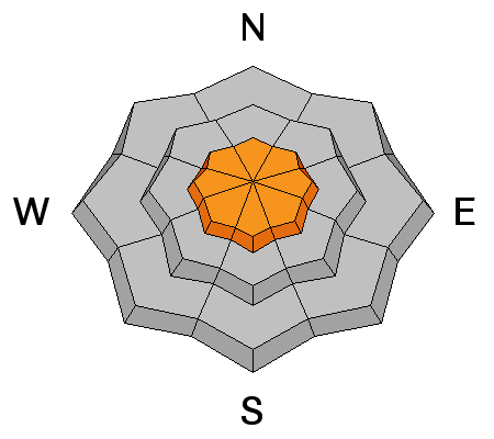
The sun is high in the sky and it's beating down on all aspects and nearly all elevations. As the snow heats up, you'll want to get off of and out from under steep, sunny slopes and avoid terrain traps like gullies where wet debris can stack up very deeply.
|
 |
weather A refreshingly stunning day is on tap. Look for mostly sunny skies with temperatures on the cool side, only rising into the low 30's. Overnight lows dive into the teens. East and northeast winds will be a nuisance along the ridges, gusting into the 30's and 40's, decreasing as the day progresses. Warm and sunny through the end of the week with a potentially weak storm slated for Saturday.
|
| general announcements Remember your information can save lives. If you see anything we should know about, please participate in the creation of our own community avalanche advisory by submitting snow and avalanche conditions. You can call me directly at 801-231-2170, email [email protected], or email by clicking HERE This is a great time of year to schedule a free avalanche awareness presentation for your group or club. You can contact me at 801-231-2170 or email [email protected] Donate to your favorite non-profit –The Utah Avalanche Center. The UAC depends on contributions from users like you to support our work. Benefit the Utah Avalanche Center when you buy or sell on ebay - set the Utah Avalanche Center as a favorite non-profit in your ebay account here and click on ebay gives when you buy or sell. You can choose to have your seller fees donated to the UAC, which doesn't cost you a penny. Utah Avalanche Center mobile app - Get your advisory on your iPhone along with great navigation and rescue tools. The information in this advisory is from the US Forest Service which is solely responsible for its content. This advisory describes general avalanche conditions and local variations always occur. I will update this advisory by 7:00 AM on Saturday Mar. 15, 2014 or sooner if conditions warrant. |


_0.jpg)