
| During the month of April, Mark Miller will donate $75 to the charity of your choice (5 to chose from, including the Utah Avalanche Center!) Mark Miller Subaru has raised over $300k in the previous 6 Do Good Feel Good events. More Info here |  |
| During the month of April, Mark Miller will donate $75 to the charity of your choice (5 to chose from, including the Utah Avalanche Center!) Mark Miller Subaru has raised over $300k in the previous 6 Do Good Feel Good events. More Info here | |
| Advisory: Uintas Area Mountains | Issued by Craig Gordon for Sunday - March 9, 2014 - 5:21am |
|---|


|
bottom line At and above treeline in the wind zone, a CONSIDERABLE avalanche danger exists and human triggered avalanches are probable on all steep, wind drifted slopes, particularly those facing the north half of the compass. Once triggered, today's avalanches can break deep and wide, creating a very dangerous slide. The danger of wet avalanche activity will rise to MODERATE during the heat of the day and human triggered avalanches will become possible on steep sun exposed slopes as the day wares on.
.
|
 |
special announcement It is with a heavy heart that I have to report an avalanche accident which occurred late Friday near Gold Hill in Whitney Basin. Ryan Noorda was wearing an avalanche beacon when he was caught and buried in a slide he triggered late in the day. Despite heroic efforts brought forth by his brother, local rider Mike Alardi and his son, and both Uinta and Summit County Search and Rescue, Ryan was tragically killed. Our collective thoughts, prayers, and energy go out to Ryan's friends and family. Our investigation can be found here
|
 |
current conditions High pressure over the region is giving us clear skies this morning with temperatures in the mid 20's and low 30's. Westerly winds increased around midnight and are blowing 20-25 mph along the high ridges. Temperatures are in the mid 20's and low 30's. Yesterday's strong sun baked southerly facing slopes and they'll crusty this morning, but add a bit of shade to your travels and you'll still find soft settled powder. Click here for current winds, temperatures, and snowfall throughout the range. Click here for trip reports and avalanche observations.
|
 |
recent activity
An overview of Friday's avalanche accident in Gold Hill Basin. A viddy describing the accident can be found here. More avalanche activity is found here.
|
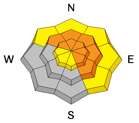
| type | aspect/elevation | characteristics |
|---|

|
|
LIKELIHOOD
 LIKELY
UNLIKELY
SIZE
 LARGE
SMALL
TREND
 INCREASING DANGER
SAME
DECREASING DANGER
|
|
description
Investigating Friday's avalanche accident revealed a lot about the snowpack structure in this area, helping to confirm our theories and speculations. It's no mystery that the western Uinta's have been sketchy since the early January storm cycle, but it's remarkable how long this instability has lingered. This isn't the kind of scary that lasts a few days and then we're good to go. This is the kind of scary that lingers for weeks and is extremely hard to manage because avalanches are breaking so historically deep and wide. In addition, it's a condition we're not used to seeing this late in the season. Steep, rocky terrain facing the north half of the compass is our problem child. The only way to manage unmanageable avalanches that break to the ground is with your terrain choices. Simply avoid being on or underneath slopes with these type of characteristics. Done and done!
.
|
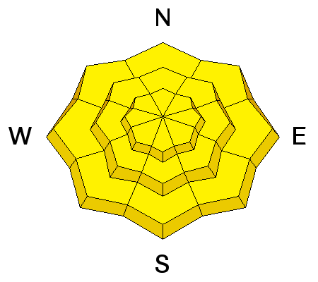
| type | aspect/elevation | characteristics |
|---|

|
|
LIKELIHOOD
 LIKELY
UNLIKELY
SIZE
 LARGE
SMALL
TREND
INCREASING DANGER
SAME
DECREASING DANGER
|
|
description
The sun is high in the sky and it's beating down on all aspects and nearly all elevations. As the snow heats up, you'll want to get off of and out from under steep, sunny slopes and avoid terrain traps like gullies where wet debris can stack up very deeply.
|
 |
weather High pressure slides east of the region later today, allowing for a mild southwesterly flow to develop this afternoon through much of Monday. We should see increasing high clouds throughout the day with temperatures climbing into the low to mid 40's. Clouds increase overnight and a Pacific cold front crosses the area Monday evening, bringing periods of snow through Tuesday. Looks like 4"-8" is a good bet by Wednesday morning. High pressure builds for the second half of the week.
|
| general announcements Remember your information can save lives. If you see anything we should know about, please participate in the creation of our own community avalanche advisory by submitting snow and avalanche conditions. You can call me directly at 801-231-2170, email [email protected], or email by clicking HERE This is a great time of year to schedule a free avalanche awareness presentation for your group or club. You can contact me at 801-231-2170 or email [email protected] Donate to your favorite non-profit –The Utah Avalanche Center. The UAC depends on contributions from users like you to support our work. Benefit the Utah Avalanche Center when you buy or sell on ebay - set the Utah Avalanche Center as a favorite non-profit in your ebay account here and click on ebay gives when you buy or sell. You can choose to have your seller fees donated to the UAC, which doesn't cost you a penny. Utah Avalanche Center mobile app - Get your advisory on your iPhone along with great navigation and rescue tools. The information in this advisory is from the US Forest Service which is solely responsible for its content. This advisory describes general avalanche conditions and local variations always occur. I will update this advisory by 7:00 AM on Wednesday Mar. 12, 2014 or sooner if conditions warrant. |


_0.jpg)

