| During the month of April, Mark Miller will donate $75 to the charity of your choice (5 to chose from, including the Utah Avalanche Center!) Mark Miller Subaru has raised over $300k in the previous 6 Do Good Feel Good events. More Info here |  |
| During the month of April, Mark Miller will donate $75 to the charity of your choice (5 to chose from, including the Utah Avalanche Center!) Mark Miller Subaru has raised over $300k in the previous 6 Do Good Feel Good events. More Info here | |
| Advisory: Uintas Area Mountains | Issued by Craig Gordon for Wednesday - March 5, 2014 - 5:35am |
|---|

|
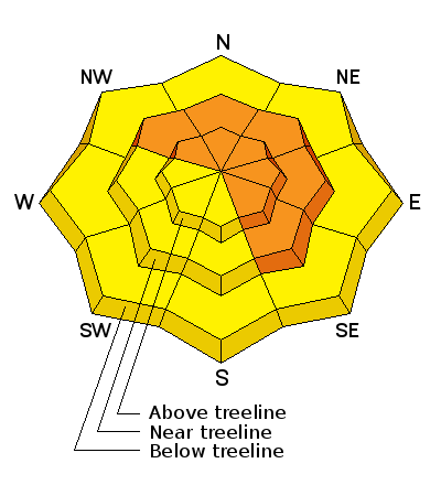
bottom line While not widespread, above treeline in the wind zone, a CONSIDERABLE danger exists and human triggered avalanches are probable on all steep, wind drifted slopes, particularly those facing the north half of the compass. Once triggered, today's avalanches can break deep and wide, creating a very dangerous slide. Strong sunshine will increase the avalanche danger to MODERATE during the heat of the day and human triggered avalanches will become possible on steep sun exposed slopes as the snow starts to bake.
.
|
 |
special announcement Join us March 8th and 9th at Brighton Resort for the first annual VertFest and 11th annual PowderKeg. There will be gear demos, a series of backcountry skills clinics, free beacon clinics, a party featuring the band Salem from Boulder, CO and a great gear raffle. The VertFest is a benefit for the Utah Avalanche Center. Click Here to find out more and to sign up for the backcountry clinics. Show Us You Know the Snow: US & Canadian avy groups have a challenge to sidecountry riders: Use your camera to tell a short video story about how your crew gets ready to safely ride beyond the resort boundary. Videos will be posted & promoted by GoPro & other partners. The contest will run till Mar 21. The winner will be determined by a combination of most views & an expert panel. Prizes include: 2 days at Monashee Powder Snowcats, 2 4-day Gold Passes to any US resort, a Backcountry Access Float 22 airbag, gear from Backcountry.com, editing help and support from Sherpas Cinema, & more. Winners will be announced in late March. . Details at knowthesnow.com Please share this with your friends |
 |
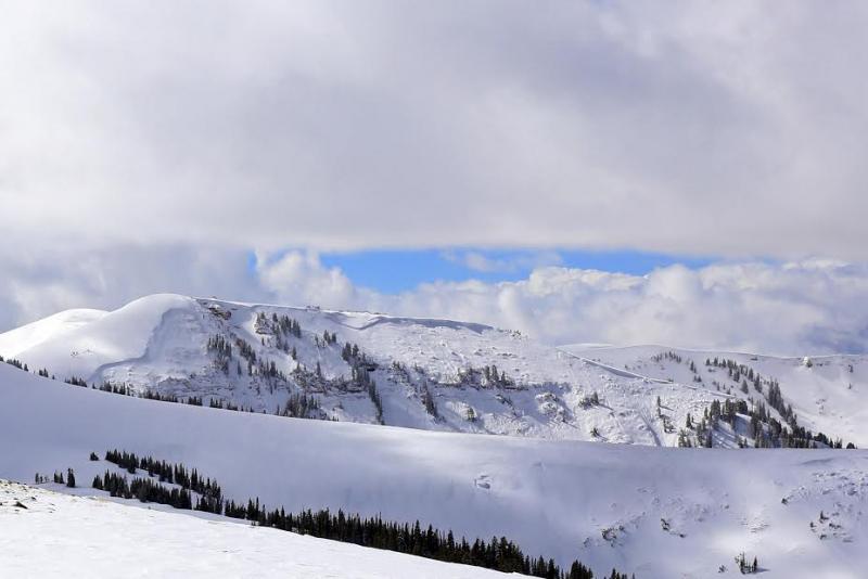
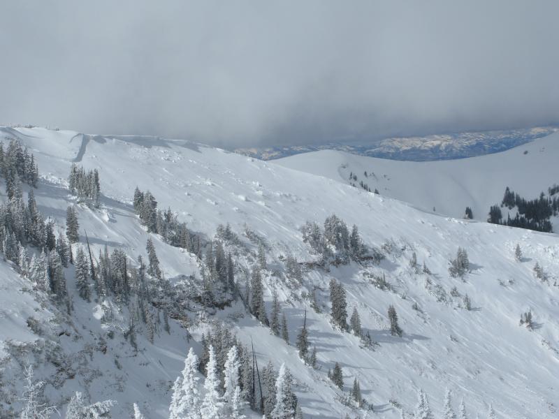
current conditions Skies cleared late yesterday in the wake of a little storm that delivered 3"-5" of snow across the range. Winds turned northwesterly around 11:00 yesterday and have been blowing 15-25 mph along the high ridges. Temperatures are in the mid teens and low 20's. It'll be a stellar day in the mountains where riding and turning conditions are outstanding on a go anywhere base. Click here for current winds, temperatures, and snowfall throughout the range. Click here for trip reports and avalanche observations.
|
 |
recent activity
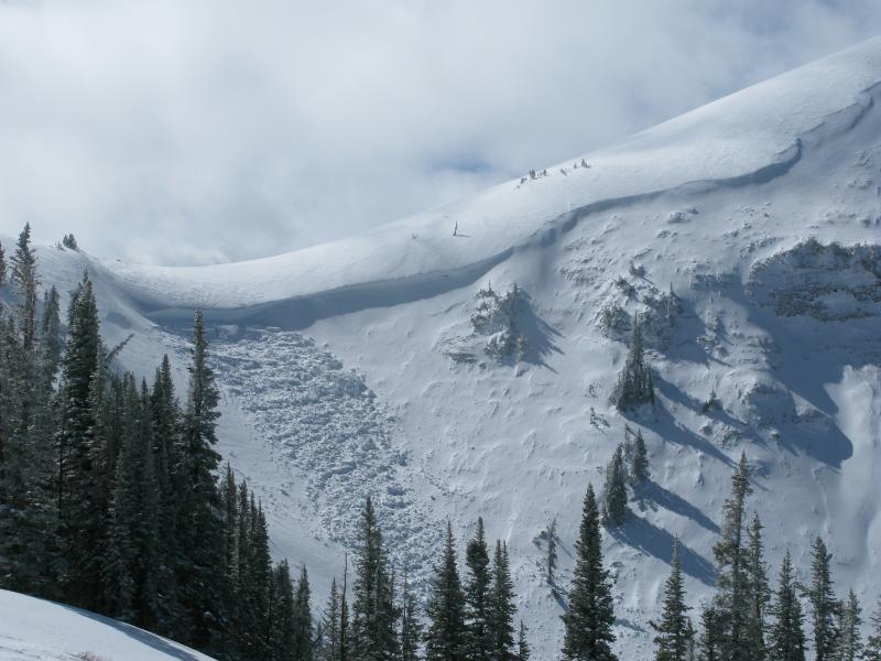
On Monday, we scoped out this huge natural slide seen here in Upper Chalk Creek. Ten feet deep and over a 1/2 mile wide, this occurred sometime Saturday as a result of the epic wind event. More info can be found here and a viddy overview here. More avalanche activity is found here.
|
| type | aspect/elevation | characteristics |
|---|

|
|
LIKELIHOOD
 LIKELY
UNLIKELY
SIZE
 LARGE
SMALL
TREND
 INCREASING DANGER
SAME
DECREASING DANGER
|
|
description
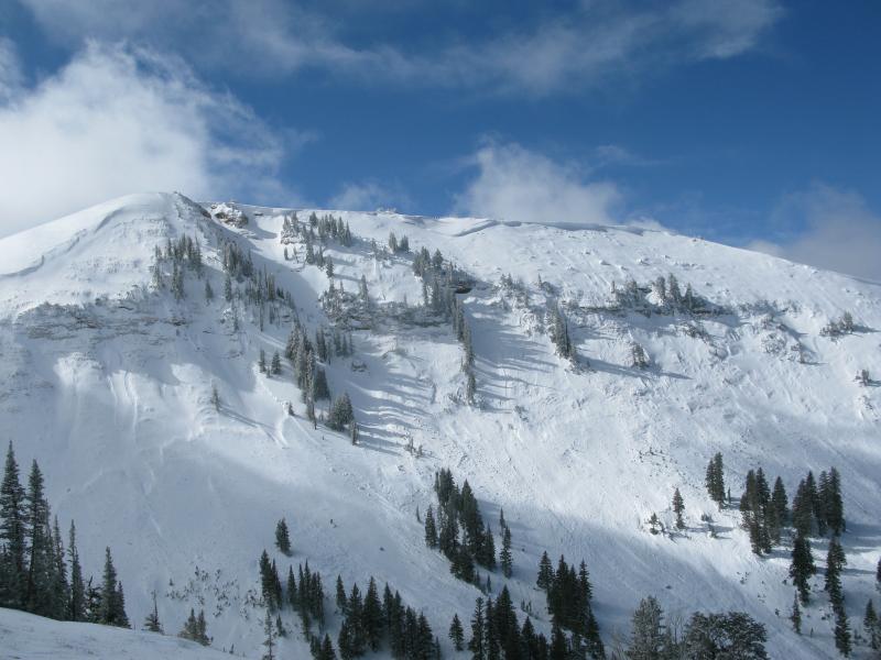
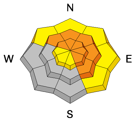
Looking at the massive Chalk Creek slide one thing is certain, our snowpack structure remains questionable, especially in steep, rocky terrain facing the north half of the compass. I know the surface snow feels solid and good to go, but it's the weak, sugary snow near the ground that's the big red flag. Strong snow over weak snow allows us to get well out onto the slope or put several sets of tracks on the hill before we find a weakness, collapse the slope, and now all bets are off. Once triggered, avalanches can break deep and wide, taking out the entire seasons snowpack. Best way to manage this situation is with terrain choices. Simply tone down your objectives and avoid being on or under steep leeward slopes.
.
|
| type | aspect/elevation | characteristics |
|---|

|
|
LIKELIHOOD
 LIKELY
UNLIKELY
SIZE
 LARGE
SMALL
TREND
INCREASING DANGER
SAME
DECREASING DANGER
|
|
description
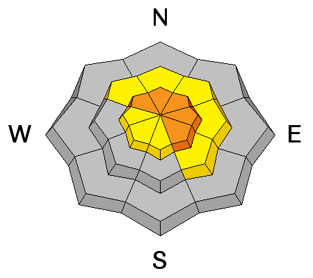
Recent winds have been all over the place forming drifts on steep leeward slopes and around terrain features like chutes and gully walls. Today's stout slabs may be a bit stubborn, but will break deeper and wider than you might expect. They're packing a hefty punch and will quickly ruin your day, especially if you get slammed into trees or knocked over a cliff. In addition, once triggered, today's drifts have the possibility to break into weaker layers of snow, buried deeper in the snowpack. In either case, a seemingly benign situation can get quickly out of hand. As always, look for and avoid any fat, rounded pillow of snow, especially if it sounds hollow like a drum.
|
| type | aspect/elevation | characteristics |
|---|

|
|
LIKELIHOOD
LIKELY
UNLIKELY
SIZE
 LARGE
SMALL
TREND
INCREASING DANGER
SAME
DECREASING DANGER
|
|
description
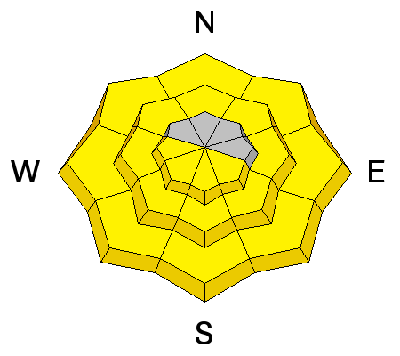
The sun is high in the sky and it's beating down on all aspects and nearly all elevations. As the snow heats up, you'll want to get off of and out from under steep, sunny slopes and avoid terrain traps like gullies where wet debris can stack up very deeply.
|
 |
weather A beautiful day is on tap for the region. Look for mostly sunny skies, temperatures warming into the low 40's, and northwest winds blowing 10-20 mph along the ridges. Winds should switch to the southwest late in the day and bump into the 30's and 40's. Increasing clouds late Thursday with snow expected through Friday. Looks like 6"-10" is a good bet by late Friday. Sunny and warm for the weekend.
|
| general announcements Remember your information can save lives. If you see anything we should know about, please participate in the creation of our own community avalanche advisory by submitting snow and avalanche conditions. You can call me directly at 801-231-2170, email [email protected], or email by clicking HERE This is a great time of year to schedule a free avalanche awareness presentation for your group or club. You can contact me at 801-231-2170 or email [email protected] Donate to your favorite non-profit –The Utah Avalanche Center. The UAC depends on contributions from users like you to support our work. Benefit the Utah Avalanche Center when you buy or sell on ebay - set the Utah Avalanche Center as a favorite non-profit in your ebay account here and click on ebay gives when you buy or sell. You can choose to have your seller fees donated to the UAC, which doesn't cost you a penny. Utah Avalanche Center mobile app - Get your advisory on your iPhone along with great navigation and rescue tools. The information in this advisory is from the US Forest Service which is solely responsible for its content. This advisory describes general avalanche conditions and local variations always occur. I will update this advisory by 7:00 AM on Saturday Mar. 8, 2014 or sooner if conditions warrant. |


_0.jpg)