
| During the month of April, Mark Miller will donate $75 to the charity of your choice (5 to chose from, including the Utah Avalanche Center!) Mark Miller Subaru has raised over $300k in the previous 6 Do Good Feel Good events. More Info here |  |
| During the month of April, Mark Miller will donate $75 to the charity of your choice (5 to chose from, including the Utah Avalanche Center!) Mark Miller Subaru has raised over $300k in the previous 6 Do Good Feel Good events. More Info here | |
| Advisory: Uintas Area Mountains | Issued by Craig Gordon for Friday - February 28, 2014 - 4:53am |
|---|

|
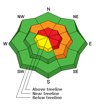
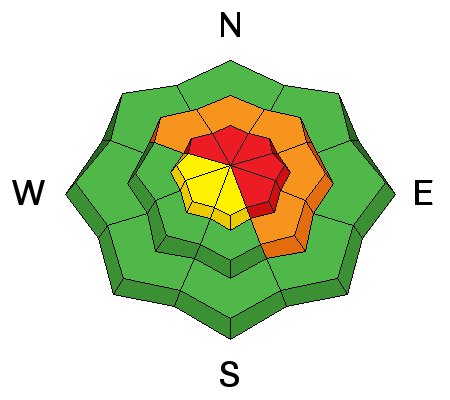
bottom line In the wind zone at upper elevations, the avalanche danger is HIGH today. Human triggered avalanches are very likely and natural avalanches are probable on all steep, wind drifted slopes, particularly those facing the north half of the compass and especially those with an easterly component to their aspect. Once triggered, today's avalanches can break deep and wide, creating a very dangerous slide. A CONSIDERABLE avalanche danger is found at mid elevations and human triggered avalanches are possible on steep, wind drifted slopes. LOW avalanche danger is found on gentle slopes with no steep terrain above or adjacent to where you're riding. .
|
 |
avalanche watch An AVALANCHE WATCH has been issued for the mountains of northern Utah and that includes the western Uinta's. Both natural and human triggered avalanches are likely on upper elevation, wind drifted slopes. Dangerous avalanche conditions will materialize this weekend as a powerful storm is expected to slam into the region tonight with strong winds and heavy snow. |
 |
current conditions February showers bring.... spring powder! Yesterday's storm delivered a nice shot of snow with 10" stacking up at the upper elevations. Westerly winds were unruly yesterday afternoon, gusting into the 40's and 50's, but mellowed somewhat around midnight and are currently blowing 15-25 mph. Temperatures are in the low to mid 20's. If you're looking for powder head to wind sheltered, mid and upper elevation terrain where you'll find soft, creamy snow, on a go anywhere kinda base. Click here for current winds, temperatures, and snowfall throughout the range. Click here for trip reports and avalanche observations.
|
 |
recent activity No news of the weird... or the wired the past day or two. Recent avalanche activity is found here.
|
| type | aspect/elevation | characteristics |
|---|

|
|
LIKELIHOOD
 LIKELY
UNLIKELY
SIZE
 LARGE
SMALL
TREND
 INCREASING DANGER
SAME
DECREASING DANGER
|
|
description
Strong winds and heavy snow will provide a one-two punch to our snowpack, which is still trying to adjust to the last series of storms. The snow structure remains questionable, especially in steep, rocky terrain facing the north half of the compass. While the surface snow feels strong and solid underneath us, it's the bad mojo near the ground that's the big red flag. Strong snow over weak snow often suggests false green light conditions, allowing us to get well out onto the slope or put several sets of tracks on the hill before we find a weakness, collapse the slope, and now all bets are off. Cornice drops and slope cuts are ineffective ways to test the stability of a slope. Best way to deal with this type of avalanche dragon is with terrain management. Steep, rocky, leeward terrain remains suspect and should be avoided. Remember- there are plenty of days left this season to get after it. Right now we have to exercise some patience.
.
|
| type | aspect/elevation | characteristics |
|---|

|

|
LIKELIHOOD
 LIKELY
UNLIKELY
SIZE
 LARGE
SMALL
TREND
INCREASING DANGER
SAME
DECREASING DANGER
|
|
description
Fresh drifts will be sensitive to the additional weight of a rider today. These should be mostly manageable in depth and width and breaking at or below our skis, board, or sled. However, in steep, rocky terrain a fresh drift has the possibility to break into weaker layers of snow, buried deeper in the snowpack, creating a slide that gets quickly out of hand. As always, look for and avoid any fat, rounded pillow of snow, especially if it sounds hollow like a drum. |
 |
weather A moist Pacific storm system moves through the region beginning today, with precipitation likely beginning in northern Utah late this afternoon or early this evening. West and southwest winds increase significantly for the latter half of today, and remain strong into Saturday morning. The region should fair pretty well with periods of snow through Saturday night.
|
| general announcements Remember your information can save lives. If you see anything we should know about, please participate in the creation of our own community avalanche advisory by submitting snow and avalanche conditions. You can call me directly at 801-231-2170, email [email protected], or email by clicking HERE This is a great time of year to schedule a free avalanche awareness presentation for your group or club. You can contact me at 801-231-2170 or email [email protected] Donate to your favorite non-profit –The Utah Avalanche Center. The UAC depends on contributions from users like you to support our work. Benefit the Utah Avalanche Center when you buy or sell on ebay - set the Utah Avalanche Center as a favorite non-profit in your ebay account here and click on ebay gives when you buy or sell. You can choose to have your seller fees donated to the UAC, which doesn't cost you a penny. Utah Avalanche Center mobile app - Get your advisory on your iPhone along with great navigation and rescue tools. The information in this advisory is from the US Forest Service which is solely responsible for its content. This advisory describes general avalanche conditions and local variations always occur. I will update this advisory by 7:00 AM on Saturday Mar. 1, 2014 |


_0.jpg)
