| During the month of April, Mark Miller will donate $75 to the charity of your choice (5 to chose from, including the Utah Avalanche Center!) Mark Miller Subaru has raised over $300k in the previous 6 Do Good Feel Good events. More Info here |  |
| During the month of April, Mark Miller will donate $75 to the charity of your choice (5 to chose from, including the Utah Avalanche Center!) Mark Miller Subaru has raised over $300k in the previous 6 Do Good Feel Good events. More Info here | |
| Advisory: Uintas Area Mountains | Issued by Craig Gordon for Sunday - February 23, 2014 - 5:40am |
|---|


|
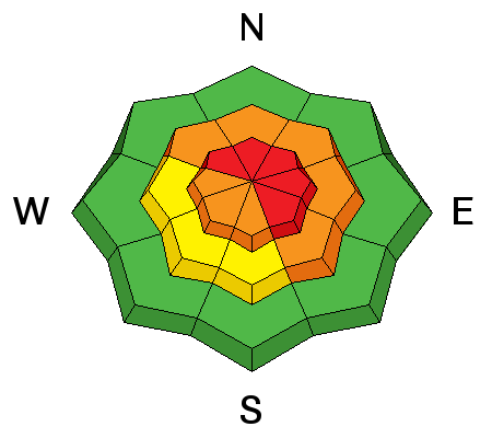
bottom line In the wind zone at upper elevations, the avalanche danger is HIGH today. Human triggered avalanches are very likely on all steep, wind drifted slopes, particularly those facing the north half of the compass and especially those with an easterly component to their aspect. Once triggered, today's avalanches can break deep and wide, creating a very dangerous slide. A CONSIDERABLE avalanche danger is found at mid elevations and human triggered avalanches are probable on steep, wind drifted slopes. LOW avalanche danger is found on gentle slopes with no steep terrain above or adjacent to where you're riding. .
|
 |
special announcement Huge thanks to everyone who helped make yesterday's Avy and Riding Skills class such a rockin' event. In particular... a huge shout out to the Park City Powdercats for hosting us and to Boondockers, Alpine Assassins, all the great instructors, and of course, everyone who attended. Thanks for all the great support! |
 |
current conditions Yesterday's little storm favored the North Slope delivering 3"-6" of very light density snow. Storm totals are about half that amount the further south in the range you travel. West and northwest winds are relentless, blowing 30-50 mph along the high peaks. Under partly cloudy skies, temperatures are in the mid 20's and low teens. Wind sheltered terrain offers soft, creamy, over-the-hood powder.. Click here for current winds, temperatures, and snowfall throughout the range. Click here for trip reports and avalanche observations.
|
 |
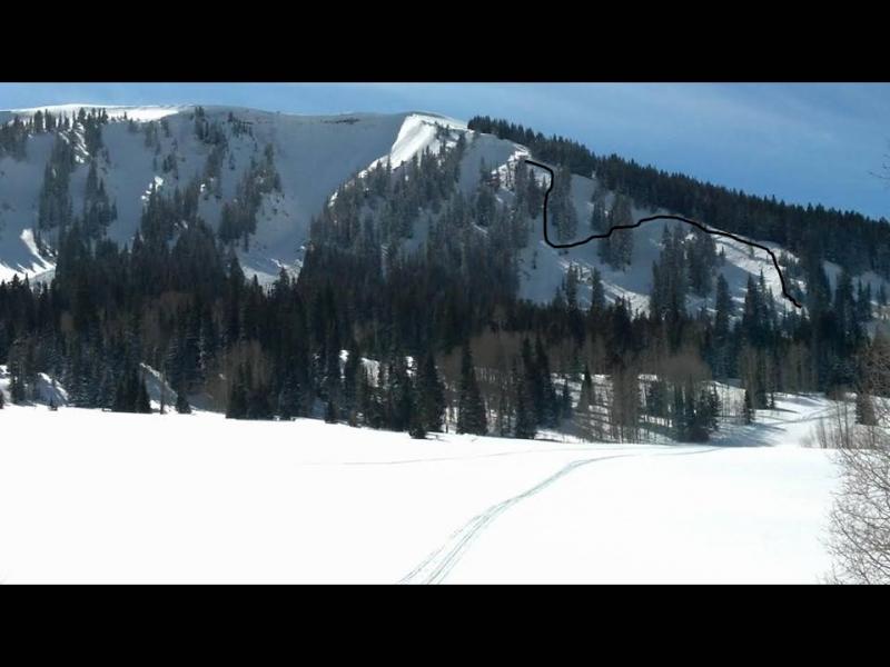
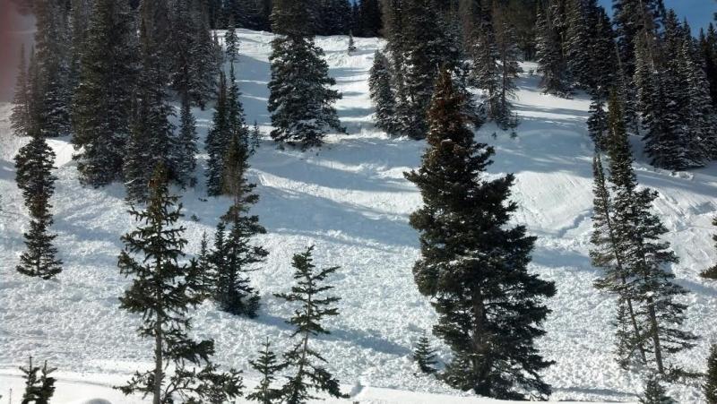
recent activity This skier triggered avalanche occurred Friday in Upper Chalk Creek. Helmet cam viddy can be seen here. Breaking 3' deep and several hundred feet wide, had this slide been triggered lower on the slope it could've been a close call.
More avalanche activity is found here.
|
| type | aspect/elevation | characteristics |
|---|

|

|
LIKELIHOOD
 LIKELY
UNLIKELY
SIZE
 LARGE
SMALL
TREND
 INCREASING DANGER
SAME
DECREASING DANGER
|
|
description
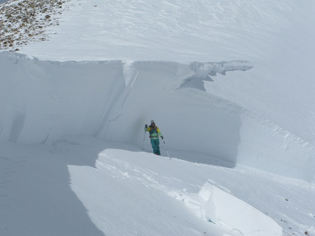
Nothing has changed on this front and one of our colleagues from Colorado wrote this about deep, persistent issues in a snowpack- It's hard to gain much experience with deep persistent slabs without getting killed. People generally underestimate the size and destructive potential of this type of avalanche, precisely because most people haven't seen many of them. The only effective strategy for managing this avalanche problem is to avoid suspect slopes. Once deep persistent slabs develop, it means you have to rein in your terrain choices, perhaps for the rest of the season. The hard part is that so many people get away with skiing on deep slabs. After all, the odds are in your favor. It really is a game of Russian Roulette. You may have more than 6 chambers (maybe 50 or 100), but there is still a deadly bullet in there. There is very little room for error. If you hit the spot, you're unlikely to walk away from these avalanches and learn your lesson with a close call
This is the kind of avalanche dragon we're dealing with... deep, wide, and dangerous. If the avalanche doesn't kill you, the dense, heavy, blocks of snow will.
.
|
| type | aspect/elevation | characteristics |
|---|

|
|
LIKELIHOOD
LIKELY
UNLIKELY
SIZE
 LARGE
SMALL
TREND
INCREASING DANGER
SAME
DECREASING DANGER
|
|
description
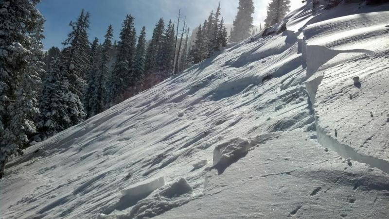
Winds have been all over the place, creating fresh drifts not only on the leeward side of upper elevation ridges, but also getting down into mid and lower elevation terrain as well. Today you'll want to look for and avoid fat, rounded pillows of snow and they may have formed around terrain features like chutes, gullies, and sub-ridges. Once triggered, today's fresh slabs have the possibility to break into weak layers of snow buried deeper in the snowpack, producing a slide that gets quickly out of hand.
The storm snow is well connected and wind drifts are breaking deeper and wider than you might expect. |
| type | aspect/elevation | characteristics |
|---|

|
|
LIKELIHOOD
LIKELY
UNLIKELY
SIZE
 LARGE
SMALL
TREND
INCREASING DANGER
SAME
DECREASING DANGER
|
|
description
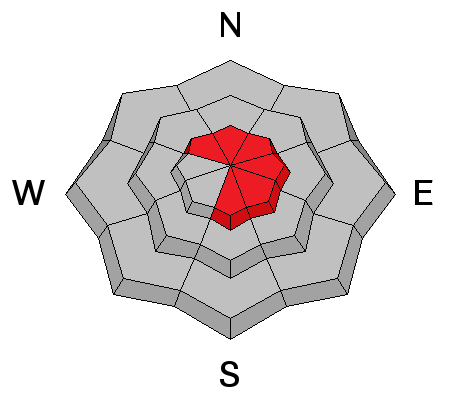
Cornices have grown quite large and will break back further than you might expect. You'll definitely want to give these boxcar sized monsters the respect they deserve.
|
 |
weather Sunny and warm for today with high temperatures climbing into the low 30's. West winds will be a nuisance along the ridges, blowing in the 30's and 40's. A weak system grazes northern Utah Monday night and Tuesday bringing a chance of snow. A warmer southwest flow develops Wednesday ahead of an active pattern slated for the latter half of the week..
|
| general announcements Remember your information can save lives. If you see anything we should know about, please participate in the creation of our own community avalanche advisory by submitting snow and avalanche conditions. You can call me directly at 801-231-2170, email [email protected], or email by clicking HERE This is a great time of year to schedule a free avalanche awareness presentation for your group or club. You can contact me at 801-231-2170 or email [email protected] Donate to your favorite non-profit –The Utah Avalanche Center. The UAC depends on contributions from users like you to support our work. Benefit the Utah Avalanche Center when you buy or sell on ebay - set the Utah Avalanche Center as a favorite non-profit in your ebay account here and click on ebay gives when you buy or sell. You can choose to have your seller fees donated to the UAC, which doesn't cost you a penny. Utah Avalanche Center mobile app - Get your advisory on your iPhone along with great navigation and rescue tools. The information in this advisory is from the US Forest Service which is solely responsible for its content. This advisory describes general avalanche conditions and local variations always occur. I will update this advisory by 7:00 AM on Wednesday Feb. 26, 2014 |


_0.jpg)