| During the month of April, Mark Miller will donate $75 to the charity of your choice (5 to chose from, including the Utah Avalanche Center!) Mark Miller Subaru has raised over $300k in the previous 6 Do Good Feel Good events. More Info here |  |
| During the month of April, Mark Miller will donate $75 to the charity of your choice (5 to chose from, including the Utah Avalanche Center!) Mark Miller Subaru has raised over $300k in the previous 6 Do Good Feel Good events. More Info here | |
| Advisory: Uintas Area Mountains | Issued by Craig Gordon for Thursday - February 20, 2014 - 5:52am |
|---|

|
bottom line In the wind zone at upper elevations, the avalanche danger is HIGH today. Human triggered avalanches are very likely and natural avalanches are probable on all steep, wind drifted slopes. Once triggered, today's avalanches can break deep and wide, creating a very dangerous slide. A CONSIDERABLE avalanche danger is found at mid elevations and human triggered avalanches are probable on steep, wind drifted slopes. LOW avalanche danger is found on gentle slopes with no steep terrain above or adjacent to where you're riding. .
|
 |
current conditions Yesterday's storm delivered a nice shot of snow across the range with 6"-8" of light density powder stacking up at most locations. Winds switched to the northwest around 9:00 Wednesday morning and have been cranking in the 40's and 50's near the high peaks. Temperatures crashed with the cold front and are currently in the single digits and below zero at the upper elevations. Add in a bit of wind chill and it's nearly -30 degrees along the ridges. Soft, creamy snow is found in wind sheltered low and mid elevation terrain. Click here for current winds, temperatures, and snowfall throughout the range. Click here for trip reports and avalanche observations.
|
 |
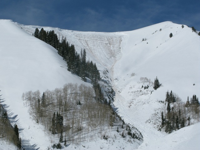
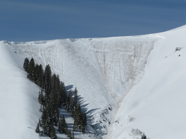
recent activity Other than this slide below which occurred on Tuesday, there's no recent news of the weird.
We found this rather large avalanche Tuesday in upper Weber Canyon. Breaking 10'-15' deep, 700' wide, and running close to 1500' vertically, this may have been the largest slide we've seen in this truly epic avalanche cycle
Strong westerly winds Monday tipped the balance, allowing a minivan sized piece of cornice to break off, slam onto the slope below, which in turn triggered this massive slide.
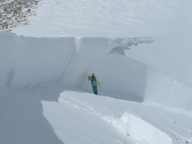
Walking in the land of giants.... Shaun Raskin looking mighty small next to this enormous crown. More avalanche activity is found here.
|
| type | aspect/elevation | characteristics |
|---|

|
|
LIKELIHOOD
 LIKELY
UNLIKELY
SIZE
 LARGE
SMALL
TREND
 INCREASING DANGER
SAME
DECREASING DANGER
|
|
description
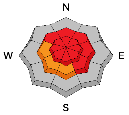
We've allowed the avalanche warning for the western Uinta's to expire, but that doesn't mean the monsters buried deep in our snowpack have magically disappeared. As a matter of fact, I'm still very suspicious of any steep, wind drifted, upper elevation slope, especially if it faces the north half of the compass. Adding yet another variable to an already complex situation is the switch in wind direction and now I suspect south facing terrain is getting in on the act too. In either case, a strong cohesive slab rests on weak sugary snow near the ground. Problem is, this snow feels bomber and good to go under our skis, board, or sled. Remember- all you need to do is find a weakness in the pack, usually around a rock or bush hidden under the snow, collapse the slope, and then all bets are off. Triggering an avalanche that breaks to the ground will have devastating and unsurvivable consequences. Best way to manage the unmanageable is with terrain choices. Simply avoid being on or under steep wind drifted terrain.
.
|
| type | aspect/elevation | characteristics |
|---|

|
|
LIKELIHOOD
LIKELY
UNLIKELY
SIZE
 LARGE
SMALL
TREND
INCREASING DANGER
SAME
DECREASING DANGER
|
|
description
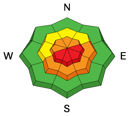
Winds have been all over the place, creating fresh drifts not only on the leeward side of upper elevation ridges, but also getting down into mid and lower elevation terrain as well. Today you'll want to look for and avoid fat, rounded pillows of snow and they may have formed around terrain features like chutes, gullies, and sub-ridges. Once triggered, today's fresh slabs have the possibility to break into weak layers of snow buried deeper in the snowpack, producing a slide that gets quickly out of hand. |
| type | aspect/elevation | characteristics |
|---|

|
|
LIKELIHOOD
LIKELY
UNLIKELY
SIZE
 LARGE
SMALL
TREND
INCREASING DANGER
SAME
DECREASING DANGER
|
|
description
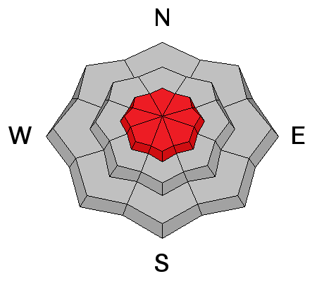
Cornices have grown ridiculously large and will break back further than you might expect. You'll definitely want to give these boxcar sized monsters the respect they deserve.
|
 |
weather A west to northwest flow continues across northern Utah through the end of the week, producing light snow and strong ridgetop winds gusting into the 50's and 60's along the high peaks. Temperatures barely climb into the teens today and dip into the single digits overnight. High pressure slowly builds for early next week.
|
| general announcements Remember your information can save lives. If you see anything we should know about, please participate in the creation of our own community avalanche advisory by submitting snow and avalanche conditions. You can call me directly at 801-231-2170, email [email protected], or email by clicking HERE This is a great time of year to schedule a free avalanche awareness presentation for your group or club. You can contact me at 801-231-2170 or email [email protected] Donate to your favorite non-profit –The Utah Avalanche Center. The UAC depends on contributions from users like you to support our work. Benefit the Utah Avalanche Center when you buy or sell on ebay - set the Utah Avalanche Center as a favorite non-profit in your ebay account here and click on ebay gives when you buy or sell. You can choose to have your seller fees donated to the UAC, which doesn't cost you a penny. Utah Avalanche Center mobile app - Get your advisory on your iPhone along with great navigation and rescue tools. The information in this advisory is from the US Forest Service which is solely responsible for its content. This advisory describes general avalanche conditions and local variations always occur. I will update this advisory by 7:00 AM on Saturday Feb. 22, 2014 |


_0.jpg)