| During the month of April, Mark Miller will donate $75 to the charity of your choice (5 to chose from, including the Utah Avalanche Center!) Mark Miller Subaru has raised over $300k in the previous 6 Do Good Feel Good events. More Info here |  |

For every car Mark MIller Subaru sells in April, they will donate $75 to the charity of your choice (5 to choose from). Who are you going to choose? Plus - you can vote for your favorite and the 3 groups receiving the most votes get an additional cash prize donated by Mark Miller Subaru. Details here

| During the month of April, Mark Miller will donate $75 to the charity of your choice (5 to chose from, including the Utah Avalanche Center!) Mark Miller Subaru has raised over $300k in the previous 6 Do Good Feel Good events. More Info here |  |
| Advisory: Uintas Area Mountains | Issued by Craig Gordon for Tuesday - February 18, 2014 - 5:00am |
|---|
 |
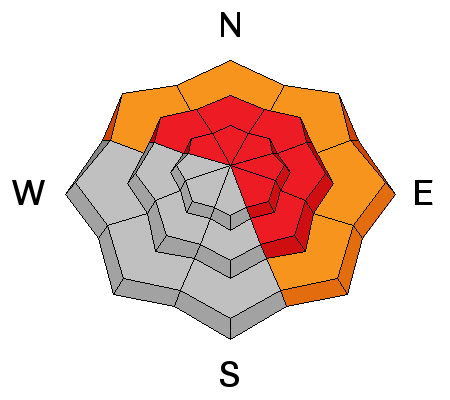
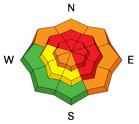
avalanche warning AN AVALANCHE WARNING CONTINUES FOR THE WESTERN UINTA MOUNTAINS WHERE THE COMBINATION OF STRONG WINDS AND RECENT SNOWFALL HAVE OVERLOADED A WEAK, FRAGILE SNOWPACK, A HIGH AVALANCHE DANGER EXISTS. DANGEROUSLY LARGE, HUMAN TRIGGERED AVALANCHES ARE LIKELY ON STEEP WIND DRIFTED SLOPES. BACKCOUNTRY TRAVELERS SHOULD AVOID SLOPES STEEPER THAN 30 DEGREES AND AVALANCHE RUNNOUT AREAS. THIS WARNING DOES NOT INCLUDE SKI AREAS OR HIGHWAYS WHERE AVALANCHE CONTROL IS NORMALLY DONE.
|
 |
current conditions Skies are clear, temperatures are in the low to mid teens and winds are relentless. Since Wednesday morning west-southwest winds have been blowing 30-50 mph near the ridges with gusts to 70 mph along the high peaks. Wind exposed slopes are jacked and bare in some places, but lose a little elevation and you'll find soft, creamy snow in wind sheltered low and mid elevation terrain. Click here for current winds, temperatures, and snowfall throughout the range. Click here for trip reports and avalanche observations.
|
 |
recent activity
This slide in Upper Weber Canyon was remotely triggered from the ridgeline nearby.
A large natural slide in Chalk Creek that released on Monday.
Superbowl avalanched wall to wall on Monday as well. More avalanche activity is found here.
|
| type | aspect/elevation | characteristics |
|---|


|


|

LIKELIHOOD
 LIKELY
UNLIKELY
SIZE
 LARGE
SMALL
TREND
 INCREASING DANGER
SAME
DECREASING DANGER
|
|
description
It's been a truly remarkable avalanche cycle and the madness continues. Avalanches are breaking deep and wide, failing on weak snow near the ground. It's an unmanageable avalanche problem with devastating consequences if we do trigger a slide. Problem is.... you can ride plenty of slopes and not trigger a deep, dangerous slide, but all you need to do is find a weakness in the pack, usually around a rock or bush hidden under the snow, collapse the slope, and then all bets are off. Best way to manage the unmanageable is with terrain choices. Simply avoid being on or under steep wind drifted terrain.
.
|
| type | aspect/elevation | characteristics |
|---|


|


|

LIKELIHOOD
 LIKELY
UNLIKELY
SIZE
 LARGE
SMALL
TREND
 INCREASING DANGER
SAME
DECREASING DANGER
|
|
description
Winds have been ruthless at mid and upper elevations, and they continue moving a tremendous amount of snow around, forming fresh slabs on the leeward side of ridges and around terrain features like chutes, gullies, and sub-ridges. Today's drifts are bordering on unmanageable in both depth and width. Once triggered, they have the possibility to break into weak layers of snow buried deeper in the snowpack, creating a slide that gets quickly out of hand. As always, look for and avoid any fresh rounded drift, especially if it feels hollow or sounds like a drum. |
| type | aspect/elevation | characteristics |
|---|


|


|

LIKELIHOOD
 LIKELY
UNLIKELY
SIZE
 LARGE
SMALL
TREND
 INCREASING DANGER
SAME
DECREASING DANGER
|
|
description
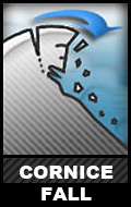
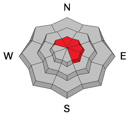
Cornices have grown huge and will break back further than you might expect. You'll definitely want to give these boxcar sized monsters the respect they deserve.
|
 |
weather Clouds stream into the area today ahead of an active pattern slated to impact the region. Westerly winds continue to punish the ridges, blowing to 45 mph throughout the day into this evening. High temperatures reach into the low 30's and dip into the low 20's. Snow develops Wednesday and we should see 6"-10" of light density snow stacking up by Thursday morning.
|
| general announcements Remember your information can save lives. If you see anything we should know about, please participate in the creation of our own community avalanche advisory by submitting snow and avalanche conditions. You can call me directly at 801-231-2170, email [email protected], or email by clicking HERE This is a great time of year to schedule a free avalanche awareness presentation for your group or club. You can contact me at 801-231-2170 or email [email protected] Donate to your favorite non-profit –The Utah Avalanche Center. The UAC depends on contributions from users like you to support our work. Benefit the Utah Avalanche Center when you buy or sell on ebay - set the Utah Avalanche Center as a favorite non-profit in your ebay account here and click on ebay gives when you buy or sell. You can choose to have your seller fees donated to the UAC, which doesn't cost you a penny. Utah Avalanche Center mobile app - Get your advisory on your iPhone along with great navigation and rescue tools. The information in this advisory is from the US Forest Service which is solely responsible for its content. This advisory describes general avalanche conditions and local variations always occur. I will update this advisory by 7:00 AM on Wednesday Feb. 19, 2014 |
Advisory Hotline: (888) 999-4019 | Contact Information