| During the month of April, Mark Miller will donate $75 to the charity of your choice (5 to chose from, including the Utah Avalanche Center!) Mark Miller Subaru has raised over $300k in the previous 6 Do Good Feel Good events. More Info here |  |
| During the month of April, Mark Miller will donate $75 to the charity of your choice (5 to chose from, including the Utah Avalanche Center!) Mark Miller Subaru has raised over $300k in the previous 6 Do Good Feel Good events. More Info here | |
| Advisory: Uintas Area Mountains | Issued by Craig Gordon for Monday - February 17, 2014 - 5:29am |
|---|

|
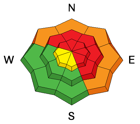
bottom line Don't let a sunny day with fresh snow skew your decision making process today. This is when most avalanche accidents occur in the western Uinta's. At upper elevations, the avalanche danger is HIGH today. Human triggered avalanches are very likely on all steep, wind drifted slopes. The danger is most pronounced on slopes facing the north half of the compass, particularly those with an easterly component to their aspect. The danger is less pronounced on south facing terrain.
|
 |
avalanche warning THIS AVALANCHE WARNING IS FOR THE MOUNTAINS OF NORTHERN AND CENTRAL UTAH. A HIGH AVALANCHE DANGER CONTINUES WITH LARGE, HUMAN TRIGGERED AVALANCHES POSSIBLE. BACKCOUNTRY TRAVELERS SHOULD AVOID SLOPES STEEPER THAN 30 DEGREES AND AVALANCHE RUNNOUT AREAS. THIS WARNING DOES NOT INCLUDE SKI AREAS OR HIGHWAYS WHERE AVALANCHE CONTROL IS NORMALLY DONE.
|
 |
current conditions Skies cleared overnight and temperatures dropped like a rock out of the sky. Currently, it's in the mid teens at most mid mountain locations and upper single digits near the high peaks. Westerly winds punished the ridges Sunday with averages in the 40's and gusts to 80 mph. Fortunately, they relaxed around midnight and are blowing 25-35 mph. Riding and turning conditions are a mixed bag. The snow down low is crusty and breakable, but gain some elevation and you'll find cool, dry powder on mid and upper elevation shady slopes. Click here for current winds, temperatures, and snowfall throughout the range. Click here for trip reports and avalanche observations.
|
 |
recent activity
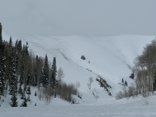
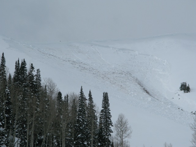
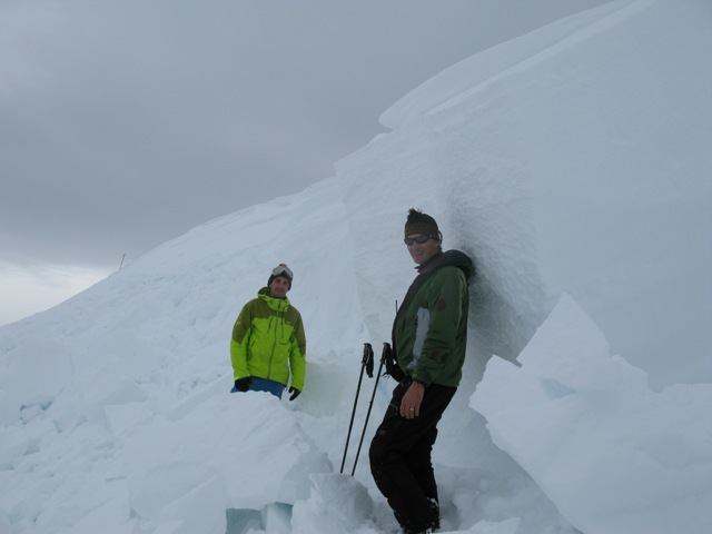
Ted and Trent stand next to a massive avalanche triggered in upper Weber Canyon Saturday. The slide was up to 10' deep, 700' wide, and ran about 1500' vertically. More avalanche activity is found here.
|
| type | aspect/elevation | characteristics |
|---|

|
|
LIKELIHOOD
 LIKELY
UNLIKELY
SIZE
 LARGE
SMALL
TREND
 INCREASING DANGER
SAME
DECREASING DANGER
|
|
description
Westerly winds were ruthless at mid and upper elevations yesterday, moving a tremendous amount of snow around, forming fresh drifts on the leeward side of ridges and terrain features like chutes, gullies, and sub-ridges. Mostly manageable in width and depth, I don't think these will be quite as sensitive today, but as always, look for and avoid any fresh rounded drift, especially if it feels hollow or sounds like a drum.
.
|
| type | aspect/elevation | characteristics |
|---|

|

|
LIKELIHOOD
LIKELY
UNLIKELY
SIZE
 LARGE
SMALL
TREND
INCREASING DANGER
SAME
DECREASING DANGER
|
|
description
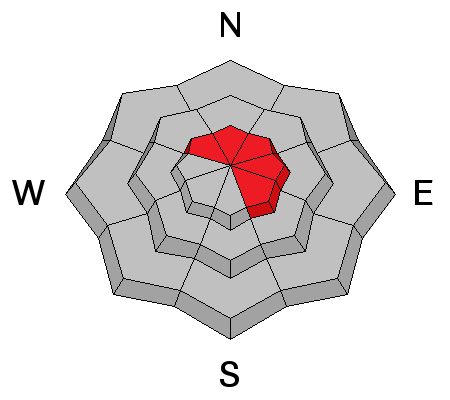
Don't get lulled into thinking shallow drifts are the only avalanche dragon out there today. We're not out of the woods with avalanches breaking into deeply buried weak layers near the ground. Sure you can ride plenty of slopes and not trigger a deep, dangerous slide, but all you need to do is find a weakness in the pack, usually around a rock or bush hidden under the snow, collapse the slope, and then all bets are off. Given the devastating consequences of triggering a slide right now, the best way to manage an unmanageable consequence is with terrain choices. Simply stay off of and out from under steep mid and upper elevation slopes, especially those facing the north half of the compass. |
| type | aspect/elevation | characteristics |
|---|

|
|
LIKELIHOOD
LIKELY
UNLIKELY
SIZE
 LARGE
SMALL
TREND
INCREASING DANGER
SAME
DECREASING DANGER
|
|
description
Cornices have grown huge and will break back further than you might expect. You'll definitely want to give these boxcar sized monsters the respect they deserve.
|
 |
weather Look for mostly sunny skies this morning with high clouds drifting into the region late in the day. Winds shift to the southwest later today and increase into the 40's and 50's along the high ridges. Temperatures climb into the mid 30's and dip into the low 20's overnight. Partly cloudy skies and cooler temperatures are on tap for Tuesday. A cold, moist storm impacts the region Wednesday.
|
| general announcements Remember your information can save lives. If you see anything we should know about, please participate in the creation of our own community avalanche advisory by submitting snow and avalanche conditions. You can call me directly at 801-231-2170, email [email protected], or email by clicking HERE This is a great time of year to schedule a free avalanche awareness presentation for your group or club. You can contact me at 801-231-2170 or email [email protected] Donate to your favorite non-profit –The Utah Avalanche Center. The UAC depends on contributions from users like you to support our work. Benefit the Utah Avalanche Center when you buy or sell on ebay - set the Utah Avalanche Center as a favorite non-profit in your ebay account here and click on ebay gives when you buy or sell. You can choose to have your seller fees donated to the UAC, which doesn't cost you a penny. Utah Avalanche Center mobile app - Get your advisory on your iPhone along with great navigation and rescue tools. The information in this advisory is from the US Forest Service which is solely responsible for its content. This advisory describes general avalanche conditions and local variations always occur. I will update this advisory by 7:00 AM on Wednesday Feb. 19, 2014 |


_0.jpg)