| During the month of April, Mark Miller will donate $75 to the charity of your choice (5 to chose from, including the Utah Avalanche Center!) Mark Miller Subaru has raised over $300k in the previous 6 Do Good Feel Good events. More Info here |  |
| During the month of April, Mark Miller will donate $75 to the charity of your choice (5 to chose from, including the Utah Avalanche Center!) Mark Miller Subaru has raised over $300k in the previous 6 Do Good Feel Good events. More Info here | |
| Advisory: Uintas Area Mountains | Issued by Craig Gordon for Friday - February 14, 2014 - 5:04am |
|---|


|
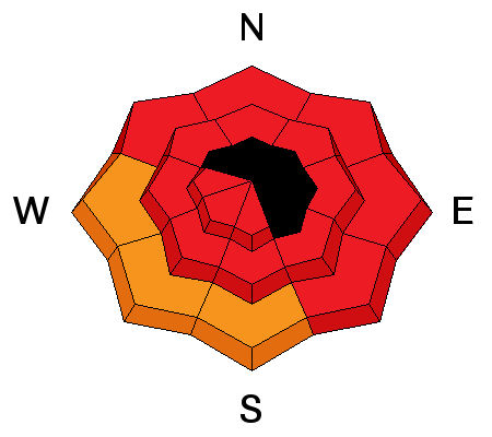
bottom line Make no mistake about it, historically large avalanches are running, fast, far, and furious. They're breaking deep and wide, taking out the entire seasons snowpack. At all elevations, the avalanche danger is HIGH today. Both natural and human triggered avalanches are very likely on all steep, snow covered slopes. The danger is most pronounced on slopes facing the north half of the compass, particularly those with an easterly component to their aspect where an EXTREME danger is found.
|
 |
avalanche warning AN AVALANCHE WARNING CONTINUES FOR THE WESTERN UINTA MOUNTAINS WHERE DEEP, DANGEROUS, AND POSSIBLY UNSURVIVABLE HUMAN TRIGGERED AND NATURAL AVALANCHES ARE LIKELY ON ALL STEEP, SNOW COVERED SLOPES. AVALANCHES CAN BE TRIGGERED FROM A DISTANCE AND LOW ON THE SLOPE.
|
 |
current conditions The madness continues and this has been an amazing storm cycle for the eastern front, particularly for the North Slope where over a foot of dense, heavy snow has fallen in the past 24 hours. West winds continue to crank along the ridges, blowing into the 40's and 50's with gusts to 70 mph near the high peaks. Temperatures are balmy, hovering right around freezing at most locations. Despite the warm and wind, riding and turning conditions are quite good in mid elevation, wind sheltered terrain. Click here for current winds, temperatures, and snowfall throughout the range. Click here for trip reports and avalanche observations.
|
 |
recent activity
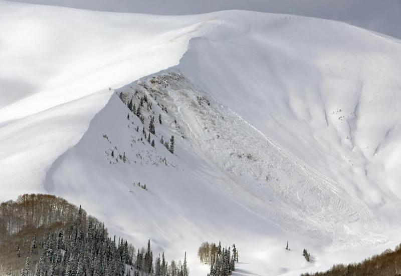
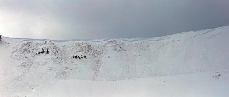
Several, very large, natural avalanches broke to the dirt yesterday in upper Weber Canyon. These bone crushing, tree snapping slides were hundreds of feet wide and up to 15' deep! A couple of riders are lucky to be alive after unintentionally triggering this slide off Currant Creek Peak on Tuesday. Details describing the slide can be found here. More avalanche activity is found here.
|
| type | aspect/elevation | characteristics |
|---|

|
|
LIKELIHOOD
 LIKELY
UNLIKELY
SIZE
 LARGE
SMALL
TREND
 INCREASING DANGER
SAME
DECREASING DANGER
|
|
description
Avalanche conditions in the western Uinta's are very dangerous. The past few days have been spooky to say the least and yesterday's natural avalanche cycle sealed the deal. Sure, we see big avalanches on the eastern front, but we're not used to a cycle of this magnitude. Avalanches aren't just breaking to the dirt, they're gouging out the ground and taking no prisoners! So here's the deal. Much of our terrain remains suspect and making matters more complicated is the fact that avalanches can be triggered low on the slope on relatively flat terrain. The danger is most pronounced on slopes facing the north half of the compass and today you need to avoid being on or below any steep, snow covered slope. It doesn't mean you can't ride. It does mean you need to consider what's hanging above you and what you're connected to. Once triggered, today's slides will easily break to weaker layers buried deep in the snowpack, resulting in a dangerous and possibly unsurvivable slide. Recent avalanches on the same type of terrain you wanna ride are huge clues to unstable snow.
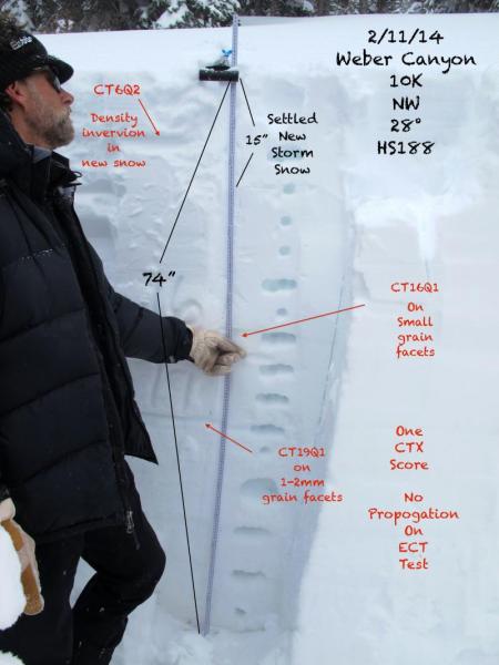
Where the pack is deep, snow stability tests are producing failures within the recent storm snow. Where the pack is shallow, the same tests are failing at the ground.
.
|
 |
weather A warm front brings cloudy skies, strong winds along the ridges, and a good shot of snow through about midday. Temperatures climb into the mid 30's and westerly winds nuke into the 60's, before diminishing late tonight. A very mild airmass brings clearing skies and record temperatures for Saturday. A fast moving cold front expected Sunday should deliver 3"-6" of snow. A break in the action for Monday/Tuesday, and then more storminess for mid week..
|
| general announcements Remember your information can save lives. If you see anything we should know about, please participate in the creation of our own community avalanche advisory by submitting snow and avalanche conditions. You can call me directly at 801-231-2170, email [email protected], or email by clicking HERE This is a great time of year to schedule a free avalanche awareness presentation for your group or club. You can contact me at 801-231-2170 or email [email protected] Donate to your favorite non-profit –The Utah Avalanche Center. The UAC depends on contributions from users like you to support our work. Benefit the Utah Avalanche Center when you buy or sell on ebay - set the Utah Avalanche Center as a favorite non-profit in your ebay account here and click on ebay gives when you buy or sell. You can choose to have your seller fees donated to the UAC, which doesn't cost you a penny. Utah Avalanche Center mobile app - Get your advisory on your iPhone along with great navigation and rescue tools. The information in this advisory is from the US Forest Service which is solely responsible for its content. This advisory describes general avalanche conditions and local variations always occur. I will update this advisory by 7:00 AM on Saturday Feb. 15, 2014 |


_0.jpg)