
| During the month of April, Mark Miller will donate $75 to the charity of your choice (5 to chose from, including the Utah Avalanche Center!) Mark Miller Subaru has raised over $300k in the previous 6 Do Good Feel Good events. More Info here |  |
| During the month of April, Mark Miller will donate $75 to the charity of your choice (5 to chose from, including the Utah Avalanche Center!) Mark Miller Subaru has raised over $300k in the previous 6 Do Good Feel Good events. More Info here | |
| Advisory: Uintas Area Mountains | Issued by Craig Gordon for Sunday - February 9, 2014 - 5:03am |
|---|

|
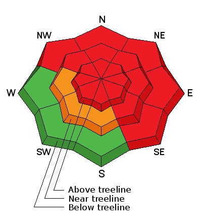
bottom line It's dangerous out there and this is the real deal. Avalanches are breaking deep and wide, taking out the entire seasons snowpack. If you're getting on the snow today, please take a moment and think about the consequences of triggering an avalanche and the possibility of not coming home to your family. At mid and upper elevations, the avalanche danger is HIGH today and borders on EXTREME in some locations. Both human triggered and natural avalanches are very likely on all steep, wind drifted slopes. The danger is most pronounced on slopes facing the north half of the compass, particularly those with an easterly component to their aspect. Once triggered avalanches have the possibility to break deep and wide, creating a dangerous and possibly unsurvivable slide. A CONSIDERABLE avalanche danger is found on steep wind drifted slopes facing the south half of the compass and human triggered avalanches are likely. Looking for LOW avalanche danger? Head to wind sheltered low elevation south facing terrain with no steep slopes above or adjacent to where you're riding.
|
 |
avalanche warning AN AVALANCHE WARNING CONTINUES FOR ALL THE MOUNTAINS OF NORTHERN AND CENTRAL UTAH...SOUTHEAST IDAHO...THE WESTERN UINTAS...AND SOUTH TO THE MANTI-SKYLINE PLATEAU TO I-70. HEAVY SNOW AND WIND HAS PUSHED THE AVALANCHE DANGER TO HIGH, BORDERING ON EXTREME. AVOID BACKCOUNTRY TRAVEL ALTOGETHER...AS LARGE NATURAL AND HUMAN TRIGGERED AVALANCHES REMAIN LIKELY IN MANY AREAS ACROSS THE STATE. |
 |
current conditions Technology is an amazing thing... when it works. However, all the automated weather stations across the western Uinta's are temporarily down and I'm kinda shootin' from the hip this morning. However, being an observer of the obvious, I know this is the biggest storm of the season with several feet of dense, heavy snow stacking up over the past couple of days, and sustained winds of biblical proportions raging along the high peaks. I also know I wouldn't be stomping on, near, or under any steep slope the next couple of days.
Click here for current winds, temperatures, and snowfall throughout the range. Click here for trip reports and avalanche observations.
|
 |
recent activity Lots of cracking, collapsing, and the biggest sign of avalanches... avalanches! Recent avalanche activity is found here.
|
| type | aspect/elevation | characteristics |
|---|

|

|
LIKELIHOOD
 LIKELY
UNLIKELY
SIZE
 LARGE
SMALL
TREND
 INCREASING DANGER
SAME
DECREASING DANGER
|
|
description
This is a huge storm for the region and winds have been all over the place, forming dense, dangerous drifts on all slopes at all elevations. Avalanches are breaking unpredictably wide and once triggered, may easily break to weaker layers buried deep in the snowpack, resulting in a dangerous and possibly unsurvivable slide. Cracking and collapsing along with recent avalanches on the same type of terrain you wanna ride are huge clues to unstable snow.
.
|
| type | aspect/elevation | characteristics |
|---|

|
|
LIKELIHOOD
 LIKELY
UNLIKELY
SIZE
 LARGE
SMALL
TREND
INCREASING DANGER
SAME
DECREASING DANGER
|
|
description
It's pretty straightforward. Strong winds, lots of water weight, and rising temperatures have severely stressed weak layers of snow near the ground, especially on slopes where the pack remains thin and fragile. Much of our terrain throughout the range is unusually shallow for this time of year and steep, rocky slopes, especially those facing the north half of the compass need to be avoided. Deep, dangerous avalanches can be triggered from relatively flat terrain low on the slope. Avalanches are running far, fast, and furious. Today you'll need to avoid being on, below, or adjacent to steep, wind drifted terrain.
|
 |
weather A moist westerly flow over the region should deliver an additional 3"-6" of snow before conditions turn more showery and we begin to dry out through Tuesday. In the meantime it'll be another wild day in the mountains with strong west and southwest winds gusting in the 50's along the high ridges. Temperatures rise into the mid 30's, before dipping into the low 20's overnight. A few snow showers are on tap for Monday, a break in the action is slated for Tuesday, and then a return to wet and windy weather for the end of the week.
|
| general announcements Remember your information can save lives. If you see anything we should know about, please participate in the creation of our own community avalanche advisory by submitting snow and avalanche conditions. You can call me directly at 801-231-2170, email [email protected], or email by clicking HERE This is a great time of year to schedule a free avalanche awareness presentation for your group or club. You can contact me at 801-231-2170 or email [email protected] Donate to your favorite non-profit –The Utah Avalanche Center. The UAC depends on contributions from users like you to support our work. Benefit the Utah Avalanche Center when you buy or sell on ebay - set the Utah Avalanche Center as a favorite non-profit in your ebay account here and click on ebay gives when you buy or sell. You can choose to have your seller fees donated to the UAC, which doesn't cost you a penny. Utah Avalanche Center mobile app - Get your advisory on your iPhone along with great navigation and rescue tools. The information in this advisory is from the US Forest Service which is solely responsible for its content. This advisory describes general avalanche conditions and local variations always occur. I will update this advisory by 7:00 AM on Monday Feb. 10, 2014 |


_0.jpg)
