
| During the month of April, Mark Miller will donate $75 to the charity of your choice (5 to chose from, including the Utah Avalanche Center!) Mark Miller Subaru has raised over $300k in the previous 6 Do Good Feel Good events. More Info here |  |
| During the month of April, Mark Miller will donate $75 to the charity of your choice (5 to chose from, including the Utah Avalanche Center!) Mark Miller Subaru has raised over $300k in the previous 6 Do Good Feel Good events. More Info here | |
| Advisory: Uintas Area Mountains | Issued by Craig Gordon for Friday - February 7, 2014 - 5:42am |
|---|


|
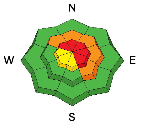
bottom line Dangerous avalanche conditions will develop the next couple of days. Above treeline in the wind zone, you'll find a HIGH danger today and human triggered avalanches are very likely on steep, wind drifted slopes. The danger is most pronounced on slopes facing the north half of the compass, particularly those with an easterly component to their aspect. As the storm evolves, avalanches will have the possibility to break deep and wide, creating a dangerous slide. A CONSIDERABLE avalanche danger is found on steep wind drifted slopes at mid elevations and human triggered avalanches are likely. South facing terrain is more predictable and offers MODERATE avalanche danger. Looking for LOW avalanche danger? Head to wind sheltered low elevation terrain with no steep slopes above or adjacent to where you're riding.
|
 |
avalanche warning THIS AVALANCHE WARNING IS FOR THE MOUNTAINS OF NORTHERN AND CENTRAL UTAH. EXPECTED SNOW AND WIND FRIDAY THROUGH THE WEEKEND WILL CREATE DANGEROUS AVALANCHE CONDITIONS. THE WARNING BEGINS IN THE LOGAN AND OGDEN AREA MOUNTAINS TODAY AND THE WASATCH RANGE, UINTA MOUNTAINS AND MANTI SKYLINE TONIGHT. DANGEROUS AVALANCHE CONDITIONS SHOULD PERSIST THROUGH THE WEEKEND. |
 |
current conditions The first in a series of storms moved into the region early this morning and light snow began around midnight. Looks like 3" of new snow has fallen at most locations, though the Mirror Lake corridor is getting pasted with nearly 10" in the past 6 hours. West and southwest winds increased overnight and are blowing 25-40 mph along the ridges. Temperatures have warmed into the teens and low 20's. Upper elevation wind exposed terrain is jacked, but soft, creamy snow can be found in wind sheltered mid and low elevation terrain. Click here for current winds, temperatures, and snowfall throughout the range. Click here for trip reports and avalanche observations.
|
 |
recent activity We were able to trigger pockety, yet sensitive wind drifts up to a foot deep yesterday on steep, wind drifted terrain in the wind zone. Recent avalanche activity is found here.
|
| type | aspect/elevation | characteristics |
|---|

|
|
LIKELIHOOD
 LIKELY
UNLIKELY
SIZE
 LARGE
SMALL
TREND
 INCREASING DANGER
SAME
DECREASING DANGER
|
|
description
Avalanche conditions are changing and we'll see an increasing avalanche danger as the storm unfolds. Yesterday, my partner and I found sensitive wind drifts, predictably breaking up to about a foot in depth. What was surprising however, was the amount of energy these small slabs had once released and man... they were packing some heat. Winds ramped up overnight and with even more snow available to blow around, I suspect drifts have grown in depth and width, breaking deeper and wider than you might expect. Today, you'll need to look for and avoid fat rounded pillows of snow and remember that cracking and collapsing of the snowpack are huge signs to unstable snow.
.
|
| type | aspect/elevation | characteristics |
|---|

|

|
LIKELIHOOD
 LIKELY
UNLIKELY
SIZE
 LARGE
SMALL
TREND
INCREASING DANGER
SAME
DECREASING DANGER
|
|
description
It's been several weeks since we've seen or heard about any avalanches breaking into deeply buried weak layers near the ground. That's good news and I think we're probably on our way to turning the corner towards a solid pack where the snow is deep and strong. However, steep, upper elevation, rocky slopes, especially those facing the north half of the compass remain unusually thin for this time of year and need to be approached with caution. Gather as much information as possible by tweaking small test slopes with similar characteristics before center-punching big terrain. Above all- think about the consequences of triggering a slide that breaks to the ground.
|
 |
weather Looks like a good pattern for northern Utah as a series of moist Pacific storms brings a long period of snow through the weekend. Snowfall ramps up throughout the day with 3"-6" expected and an additional 6" overnight. Westerly winds blow in the 20's and 30's with gusts to 40 mph along the ridges. Temperatures rise into the mid 20's with overnight lows in the teens. The heaviest snow will be Saturday and Sunday. Warming temperatures and increasing winds throughout the period will result in increasing snow density as the storm progresses.
|
| general announcements Remember your information can save lives. If you see anything we should know about, please participate in the creation of our own community avalanche advisory by submitting snow and avalanche conditions. You can call me directly at 801-231-2170, email [email protected], or email by clicking HERE This is a great time of year to schedule a free avalanche awareness presentation for your group or club. You can contact me at 801-231-2170 or email [email protected] Donate to your favorite non-profit –The Utah Avalanche Center. The UAC depends on contributions from users like you to support our work. Benefit the Utah Avalanche Center when you buy or sell on ebay - set the Utah Avalanche Center as a favorite non-profit in your ebay account here and click on ebay gives when you buy or sell. You can choose to have your seller fees donated to the UAC, which doesn't cost you a penny. Utah Avalanche Center mobile app - Get your advisory on your iPhone along with great navigation and rescue tools. The information in this advisory is from the US Forest Service which is solely responsible for its content. This advisory describes general avalanche conditions and local variations always occur. I will update this advisory by 7:00 AM on Saturday Feb. 8, 2014 |


_0.jpg)
