| During the month of April, Mark Miller will donate $75 to the charity of your choice (5 to chose from, including the Utah Avalanche Center!) Mark Miller Subaru has raised over $300k in the previous 6 Do Good Feel Good events. More Info here |  |
| During the month of April, Mark Miller will donate $75 to the charity of your choice (5 to chose from, including the Utah Avalanche Center!) Mark Miller Subaru has raised over $300k in the previous 6 Do Good Feel Good events. More Info here | |
| Advisory: Uintas Area Mountains | Issued by Craig Gordon for Wednesday - January 29, 2014 - 6:47am |
|---|

|
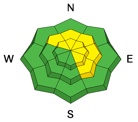
bottom line Expect a rising avalanche danger through the day This morning, you'll find a MODERATE avalanche danger on any steep wind drifted slope and human triggered avalanches are possible.While not widespread, deep, dangerous avalanches can still be triggered on steep, rocky, leeward slopes in the wind zone, especially those with an easterly component to their aspect. Go to terrain- If you're looking for LOW avalanche danger, head to wind sheltered terrain, especially where there are no steep slopes above or adjacent to where you're riding.
|
 |
avalanche watch AN AVALANCHE WATCH HAS BEEN ISSUED FOR ALL THE MOUNTAINS OF NORTHERN AND CENTRAL UTAH, TO INCLUDE THE WESTERN UINTA MOUNTAINS...AND AS FAR SOUTH AS THE FISHLAKE PLATEAU AND ALONG THE I-70 CORRIDOR. EXPECTED HEAVY SNOWFALL AND STRONG WINDS WILL CREATE DANGEROUS AVALANCHE CONDITIONS THROUGH THE REST OF THE WEEK AND INTO THE WEEKEND. |
 |
special announcement
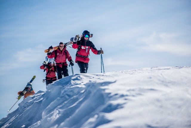
Snowbasin patrol leads the charge up the ridge. Huge thanks to Snowbasin and all the amazing athletes for bringing the stoke and hosting this years Freeride Workshop
Join the Utah Avalanche Center and Boondockers on Feb 20 and 22 for another avalanche & riding skills class. Registration is open now. Note that we changed the date from the original class posting. |
 |
current conditions Clouds are streaming into the region ahead of a series of storms slated to impact the area. West and southwest winds increased overnight and are currently blowing 25-35 along the ridges. Temperatures are in the mid 20's at most locations, though still in the upper teens along the high peaks. It's a bit underwhelming out there today. Much of our high elevation snow is wind jacked, many popular slopes are tracked out, and sun exposed terrain is hard and crusty. However, with a little snooping around, you'll find surprisingly good riding conditions on mid elevation, wind sheltered slopes.
Click here for current winds, temperatures, and snowfall throughout the range. Click here for trip reports and avalanche observations.
|
 |
recent activity
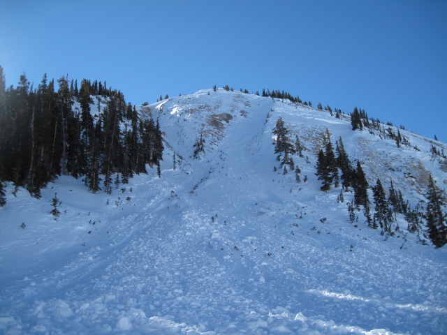
Ted was in Millcreek yesterday and noted this slide- "old news, but a nice avalanche that occurred in the upper Mill Creek drainage during the last big cycle around January 17. Much of this area is shallow, rocky and has very weak snow conditions. This is a northeast aspect with a big broad fetch on the west side where west and southwest winds strip the snow onto the leeward side."
More recent avalanche activity is found here.
|
| type | aspect/elevation | characteristics |
|---|

|
|
LIKELIHOOD
 LIKELY
UNLIKELY
SIZE
 LARGE
SMALL
TREND
 INCREASING DANGER
SAME
DECREASING DANGER
|
|
description
With more snow, wind, and water on the way, we expect a rising avalanche danger the next few days. Snow will develop during the day and winds are expected to crank along the ridges.While manageable in size and breaking at or below our skis, board, or sled, this mornings shallow wind drifts will become more sensitive to the additional weight of a rider as the day wares on.
.
|
| type | aspect/elevation | characteristics |
|---|

|
|
LIKELIHOOD
 LIKELY
UNLIKELY
SIZE
 LARGE
SMALL
TREND
INCREASING DANGER
SAME
DECREASING DANGER
|
|
description
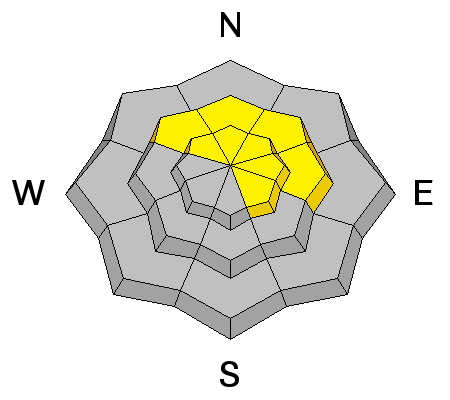
The slab has relaxed, and for the moment, the possibility of triggering deep, dangerous avalanches have diminished. However, this is gonna be a short lived respite. I expect we may reactivate buried weak layers in the pack especially if water, wind, and snow amounts stack up as expected. |
 |
weather It'll be warm and windy with rising snow levels. We expect a couple inches of dense snow today with high temperatures reaching into the mid 30's. Westerly winds are gonna crank, blowing into the 40's and 50's along the ridges with gusts to 70 mph near the high peaks. Cold air and heavy snow slides through the region late tonight and tomorrow morning with an additional foot of snow expected. Looks like unsettled weather 'til Saturday.
|
| general announcements Remember your information can save lives. If you see anything we should know about, please participate in the creation of our own community avalanche advisory by submitting snow and avalanche conditions. You can call me directly at 801-231-2170, email [email protected], or email by clicking HERE This is a great time of year to schedule a free avalanche awareness presentation for your group or club. You can contact me at 801-231-2170 or email [email protected] Donate to your favorite non-profit –The Utah Avalanche Center. The UAC depends on contributions from users like you to support our work. Benefit the Utah Avalanche Center when you buy or sell on ebay - set the Utah Avalanche Center as a favorite non-profit in your ebay account here and click on ebay gives when you buy or sell. You can choose to have your seller fees donated to the UAC, which doesn't cost you a penny. Utah Avalanche Center mobile app - Get your advisory on your iPhone along with great navigation and rescue tools. The information in this advisory is from the US Forest Service which is solely responsible for its content. This advisory describes general avalanche conditions and local variations always occur. I will update this advisory by 7:00 AM on Thursday Jan. 30, 2014 |


_0.jpg)