| During the month of April, Mark Miller will donate $75 to the charity of your choice (5 to chose from, including the Utah Avalanche Center!) Mark Miller Subaru has raised over $300k in the previous 6 Do Good Feel Good events. More Info here |  |
| During the month of April, Mark Miller will donate $75 to the charity of your choice (5 to chose from, including the Utah Avalanche Center!) Mark Miller Subaru has raised over $300k in the previous 6 Do Good Feel Good events. More Info here | |
| Advisory: Uintas Area Mountains | Issued by Craig Gordon for Thursday - January 16, 2014 - 5:05am |
|---|

|
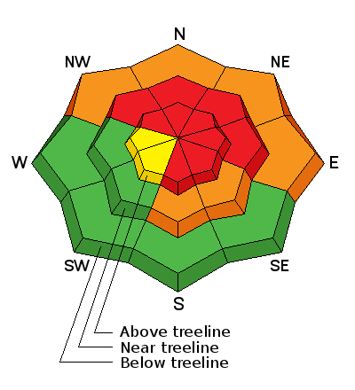
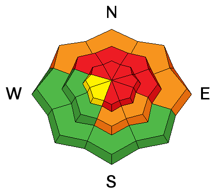
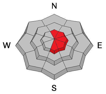
bottom line Avalanches are harder to initiate, but if you do trigger a slide the end result will be devastating! Terrain to avoid- steep, upper elevation slopes facing the north half of the compass, especially those in the wind zone with an easterly component to their aspect, where a HIGH avalanche danger exists. Human triggered avalanches are very likely. A CONSIDERABLE avalanche danger is found on any steep wind drifted slope at mid or low elevations. Human triggered avalanches are likely. Go to terrain- If you're looking for LOW avalanche danger, head to wind sheltered terrain, especially those facing the south half of the compass where there are no steep slopes above or adjacent to where you're riding.
|
 |
avalanche warning AN AVALANCHE WARNING CONTINUES FOR THE WESTERN UINTA MOUNTAINS. VERY DANGEROUS AVALANCHE CONDITIONS EXIST...AVOID BEING ON OR BENEATH STEEP MOUNTAIN SLOPES... AS AVALANCHES MAY BE TRIGGERED LOW ON THE SLOPE AS WELL. |
 |
current conditions Skies are clear and temperatures are in the mid teens. Near the ridges, northwest winds are blowing 25-35 mph. Along the high peaks they bumped up late last night and are gusting into 40's. Most wind exposed terrain is jacked, but we found soft settled powder yesterday in sheltered terrain. Meadows with no steep slopes above you are the ticket today.
Click here for current winds, temperatures, and snowfall throughout the range. Click here for trip reports and avalanche observations.
|
 |
recent activity
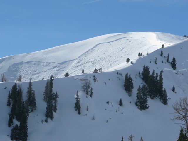
We're still catching up on all the avalanche activity and one thing is glaringly apparent... the eastern front experienced a very large natural avalanche cycle
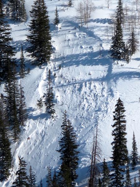
This image is from a close call on Tower Mountain occurring Saturday. Breaking over 1000' wide and failing low on slope, the avalanche took out the entire seasons snowpack. While the sled got worked, the rider came out unscathed. We learned about this avalanche through the interwebz. Please help to save lives and help our community too, by reporting what you see while riding. You can contact me directly- [email protected] or 801-231-2170... thanks! But wait... there's even more recent avalanche activity which can be found here.
|
| type | aspect/elevation | characteristics |
|---|

|
|
LIKELIHOOD
 LIKELY
UNLIKELY
SIZE
 LARGE
SMALL
TREND
 INCREASING DANGER
SAME
DECREASING DANGER
|
|
description
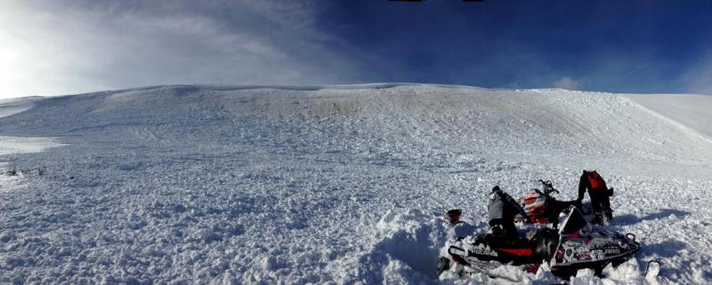
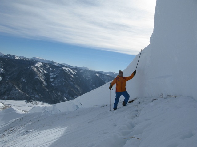
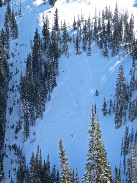
Video producer extraordinaire Trent Meisenheimer is dwarfed by this monster crown in Upper Weber Canyon. He put together a brilliant viddy describing the snowpack setup. Click here to view. Nothing has changed and our snowpack remains sketchy. Yesterday, we looked at a number of huge avalanches and on the way, experienced a few heart stopping collapses. As a matter of fact, we reevaluated our objectives and decided to pull the plug. While the snowpack slowly gains strength it remains deceptively tricky because it will feel solid under our sled, skis, or board. The snow will allow us to get well out onto the slope before it fails on sugary old snow near the ground. Once initiated, today's slides will break deep and wide, creating an unsurvivable avalanche. Complicating matters is the fact that you may still be able to trigger avalanches low on the slope or from a distance. Remember- most avalanche accidents occur the first few sunny days right after a big storm. It doesn't mean you can't ride. It does mean you need to stay off of and out from under steep wind drifted slopes, especially slopes facing the north half of the compass.
Sparse treed slopes offer little protection from the avalanche dragon
|
| type | aspect/elevation | characteristics |
|---|

|
|
LIKELIHOOD
LIKELY
UNLIKELY
SIZE
LARGE
SMALL
TREND
INCREASING DANGER
SAME
DECREASING DANGER
|
|
description
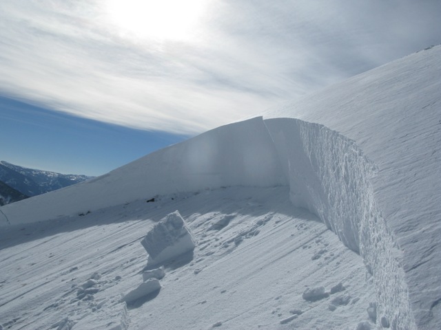
Cornices are huge, especially on the leeward side of upper elevation ridges. These monsters can easily break back further than you might expect, taking you for a nasty, unexpected ride down the elevator shaft, and possibly triggering a large avalanche as you both hit the slope below..
|
 |
weather Clear skies and temperatures warming into the low 30's are on tap as strong high pressure remains centered to our west through the end of the week. Northerly winds over the ridges will continue to gradually diminish through Friday.
|
| general announcements Remember your information can save lives. If you see anything we should know about, please participate in the creation of our own community avalanche advisory by submitting snow and avalanche conditions. You can call me directly at 801-231-2170, email [email protected], or email by clicking HERE This is a great time of year to schedule a free avalanche awareness presentation for your group or club. You can contact me at 801-231-2170 or email [email protected] Donate to your favorite non-profit –The Utah Avalanche Center. The UAC depends on contributions from users like you to support our work. Benefit the Utah Avalanche Center when you buy or sell on ebay - set the Utah Avalanche Center as a favorite non-profit in your ebay account here and click on ebay gives when you buy or sell. You can choose to have your seller fees donated to the UAC, which doesn't cost you a penny. Utah Avalanche Center mobile app - Get your advisory on your iPhone along with great navigation and rescue tools. The information in this advisory is from the US Forest Service which is solely responsible for its content. This advisory describes general avalanche conditions and local variations always occur. I will update this advisory by 7:00 AM on Friday Jan. 17, 2014 |


_0.jpg)