| During the month of April, Mark Miller will donate $75 to the charity of your choice (5 to chose from, including the Utah Avalanche Center!) Mark Miller Subaru has raised over $300k in the previous 6 Do Good Feel Good events. More Info here |  |
| During the month of April, Mark Miller will donate $75 to the charity of your choice (5 to chose from, including the Utah Avalanche Center!) Mark Miller Subaru has raised over $300k in the previous 6 Do Good Feel Good events. More Info here | |
| Advisory: Uintas Area Mountains | Issued by Craig Gordon for Monday - January 13, 2014 - 5:49am |
|---|

|
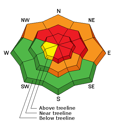
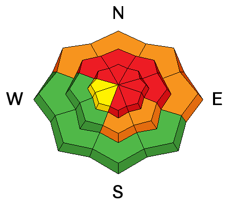
bottom line This is the real deal. We're talking... tree snapping, bone crushing, we're not coming home to our families at the end of the day, kind of avalanches. Terrain to avoid- steep, upper elevation slopes facing the north half of the compass, especially those in the wind zone with an easterly component to their aspect, where a HIGH avalanche danger exists. Both human triggered and natural avalanches are very likely. A CONSIDERABLE avalanche danger is found on any wind drifted slope at mid or low elevations. Natural and human triggered avalanches are likely. Go to terrain- If you're looking for LOW avalanche danger, head to wind sheltered terrain, especially those facing the south half of the compass where there are no steep slopes above or adjacent to where you're riding.
|
 |
avalanche warning AN AVALANCHE WARNING CONTINUES FOR THE WESTERN UINTA MOUNTAINS. VERY DANGEROUS AVALANCHE CONDITIONS EXIST...AVOID BEING ON OR BENEATH STEEP MOUNTAIN SLOPES... AS AVALANCHES MAY BE TRIGGERED LOW ON THE SLOPE AS WELL. |
 |
current conditions West winds have been relentlessly blowing 40-60 mph along the ridges for the past 24 hours and it's pretty burly out there this morning. Over a foot of snow fell since yesterday morning and temperatures are in the low teens. North Slope storm totals are nearing 28" with the south half of the range stacking up close to 2 feet. It's a wallowfest with a trapdoor, punchy, bottomless kinda base. Low angle, wind sheltered meadows with no steep slopes above or adjacent to where you're riding is the place to be.
Click here for current winds, temperatures, and snowfall throughout the range. Click here for trip reports and avalanche observations.
|
 |
recent activity
Images from a slab in Smith-Moorehouse intentionally triggered by a savvy skier while on belay. 2'-4' deep and 100' wide, the avalanche ran 800' vertical. More on this slide can be found here. Thanks to Elar for the great info! |
| type | aspect/elevation | characteristics |
|---|

|
|
LIKELIHOOD
 LIKELY
UNLIKELY
SIZE
 LARGE
SMALL
TREND
 INCREASING DANGER
SAME
DECREASING DANGER
|
|
description
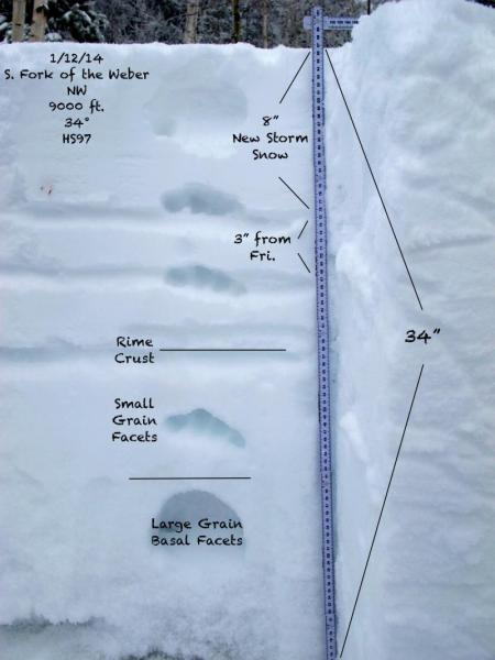
Heavy snow and strong winds continue to load our fragile snowpack. Visibilty has been marginal at best, so it's hard to say what slopes have avalanched naturally. However, my gut feeling is many steep slopes remain intact and just need a trigger like us to come along and tip the scales. Fact is, the weak snow near the ground remains highly suspect and avalanche conditions are deceptively dangerous.This is the type of setup where most avalanche accidents happen in the western Uinta's because the snowpack will feel solid and strong underneath us. Complicating matters is the fact that you can trigger avalanches low on the slope or from a distance. Once initiated, today's slides will break deep and wide, creating an unsurvivable avalanche. It doesn't mean you can't ride. It does mean you need to stay off of and out from under steep wind drifted slopes, especially slopes facing the north half of the compass.
As always, a great overview of the snowpack provided by JG. More of his outstanding observation and snowpack insight can be found here.
|
| type | aspect/elevation | characteristics |
|---|

|

|
LIKELIHOOD
LIKELY
UNLIKELY
SIZE
LARGE
SMALL
TREND
INCREASING DANGER
SAME
DECREASING DANGER
|
|
description
Cornices continue to grow, especially on the leeward side of upper elevation ridges. These monsters can easily break back further than you might expect, taking you for a nasty, unexpected ride down the elevator shaft, and possibly triggering a large avalanche as you both hit the slope below..
|
 |
weather Moisture lingers over the region through the morning with another inch or two of snow, but in general we're starting to dry out as the storm system moves east. Winds continue to gust into the 50's and 60's, eventually switching to the north by early Tuesday and diminishing into the 40's. Temperatures rise into the mid 20's today and then dip into the teens and single digits overnight under clearing skies. High pressure builds for the rest of the week.
|
| general announcements Remember your information can save lives. If you see anything we should know about, please participate in the creation of our own community avalanche advisory by submitting snow and avalanche conditions. You can call me directly at 801-231-2170, email [email protected], or email by clicking HERE This is a great time of year to schedule a free avalanche awareness presentation for your group or club. You can contact me at 801-231-2170 or email [email protected] Donate to your favorite non-profit –The Utah Avalanche Center. The UAC depends on contributions from users like you to support our work. Benefit the Utah Avalanche Center when you buy or sell on ebay - set the Utah Avalanche Center as a favorite non-profit in your ebay account here and click on ebay gives when you buy or sell. You can choose to have your seller fees donated to the UAC, which doesn't cost you a penny. Utah Avalanche Center mobile app - Get your advisory on your iPhone along with great navigation and rescue tools. The information in this advisory is from the US Forest Service which is solely responsible for its content. This advisory describes general avalanche conditions and local variations always occur. I will update this advisory by 7:00 AM on Tuesday Jan. 14, 2014 |


_0.jpg)
_0.jpg)
_0.jpg)