| During the month of April, Mark Miller will donate $75 to the charity of your choice (5 to chose from, including the Utah Avalanche Center!) Mark Miller Subaru has raised over $300k in the previous 6 Do Good Feel Good events. More Info here |  |
| During the month of April, Mark Miller will donate $75 to the charity of your choice (5 to chose from, including the Utah Avalanche Center!) Mark Miller Subaru has raised over $300k in the previous 6 Do Good Feel Good events. More Info here | |
| Advisory: Uintas Area Mountains | Issued by Craig Gordon for Sunday - January 12, 2014 - 6:19am |
|---|


|
bottom line This is the real deal. We're talking... tree snapping, bone crushing, we're not coming home to our families at the end of the day, kind of avalanches. Terrain to avoid- steep, upper elevation slopes facing the north half of the compass, especially those in the wind zone with an easterly component to their aspect, where a HIGH avalanche danger exists. Both human triggered and natural avalanches are very likely. A CONSIDERABLE avalanche danger is found on upper elevation terrain facing the south half of the compass. Natural and human triggered avalanches are likely. Go to terrain- If you're looking for LOW avalanche danger, head to wind sheltered terrain, especially those facing the south half of the compass where there are no steep slopes above or adjacent to where you're riding.
|
 |
avalanche warning THIS AVALANCHE WARNING IS FOR THE MOUNTAINS OF NORTHERN AND CENTRAL UTAH, TO INCLUDE THE WESTERN UINTA MOUNTAINS. VERY DANGEROUS AVALANCHE CONDITIONS EXIST THROUGH THE WEEKEND...AVOID BEING ON OR BENEATH STEEP MOUNTAIN SLOPES...AS AVALANCHES MAY BE TRIGGERED LOW ON THE SLOPE AS WELL. |
 |
current conditions Clouds streamed in overnight, snow began falling around 2:00 this morning, and it's stomping! So far it looks like the north slope is picking up the bulk of snow with a solid 8". Further south, it's a pretty evenly distributed storm with 3"-5" of snow stacking up. Winds switched from the southwest to the west-northwest early this morning and are blowing 40-60 mph along the ridges. The cold front is keeping the temperatures at bay and currently it's in the low teens near the peaks and mid 20's at the trailheads. It's a mixed bag out there and many slopes are either wind-jacked or heat effected. With a trapdoor, punchy kinda base, hill climbing is a joke. Low angle, wind sheltered meadows with no steep slopes above or adjacent to where you're riding is the place to be.
Click here for current winds, temperatures, and snowfall throughout the range. Click here for trip reports and avalanche observations.
|
 |
recent activity
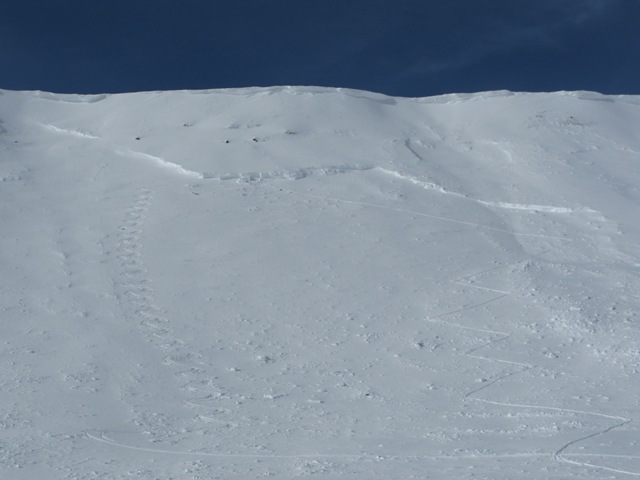
Thanks to JG for these great photos of this monster, natural slide, on a heavily wind loaded east facing slope in Smith-Moorehouse. More on his Friday obs from that area here. |
| type | aspect/elevation | characteristics |
|---|

|

|
LIKELIHOOD
 LIKELY
UNLIKELY
SIZE
 LARGE
SMALL
TREND
 INCREASING DANGER
SAME
DECREASING DANGER
|
|
description
Yesterday's clear skies allowed for some avalanche sight seeing and I wasn't all that impressed with the lack of natural avalanche activity. Sure, there were a couple of cornice triggered avalanches that resulted in big slides breaking to the ground, but it wasn't a widespread event.... and that worries me. Right now, most of big terrain throughout the range just needs a trigger like us to come along and tip the scales. While yesterday's temperatures helped shrink wrap the snowpack in the short term, not much has changed with the weak snow near the ground. It remains highly suspect and avalanche conditions are deceptively dangerous.This is the type of setup where most avalanche accidents happen in the western Uinta's because the snowpack will feel solid and strong underneath us. Complicating matters is the fact that you can trigger avalanches low on the slope or from a distance. Once initiated, today's slides will break deep and wide, creating an unsurvivable avalanche. It doesn't mean you can't ride. It does mean you need to stay off of and out from under steep wind drifted slopes, especially slopes facing the north half of the compass.
|
| type | aspect/elevation | characteristics |
|---|

|

|
LIKELIHOOD
LIKELY
UNLIKELY
SIZE
LARGE
SMALL
TREND
INCREASING DANGER
SAME
DECREASING DANGER
|
|
description
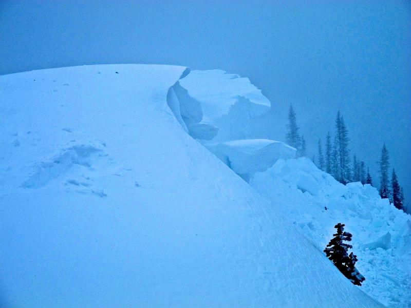
Cornices have grown huge, especially on the leeward side of upper elevation ridges. These monsters can easily break back further than you might expect, taking you for a nasty, unexpected ride down the elevator shaft, and possibly triggering a large avalanche as you both hit the slope below..
|
 |
weather A cold storm moves across the region this morning and we should see a good blast of snow with totals near a foot by the time the storm winds down later tonight. In the mean time west-northwest winds will crank in the 30's and 40's with gusts in the 50's along the high ridges. Temperatures fall throughout the day and overnight lows under clearing skies bottom out in the single digits and low teens.Partly cloudy skies for Monday with a ridge building for the upcoming week.
|
| general announcements Remember your information can save lives. If you see anything we should know about, please participate in the creation of our own community avalanche advisory by submitting snow and avalanche conditions. You can call me directly at 801-231-2170, email [email protected], or email by clicking HERE This is a great time of year to schedule a free avalanche awareness presentation for your group or club. You can contact me at 801-231-2170 or email [email protected] Donate to your favorite non-profit –The Utah Avalanche Center. The UAC depends on contributions from users like you to support our work. Benefit the Utah Avalanche Center when you buy or sell on ebay - set the Utah Avalanche Center as a favorite non-profit in your ebay account here and click on ebay gives when you buy or sell. You can choose to have your seller fees donated to the UAC, which doesn't cost you a penny. Utah Avalanche Center mobile app - Get your advisory on your iPhone along with great navigation and rescue tools. The information in this advisory is from the US Forest Service which is solely responsible for its content. This advisory describes general avalanche conditions and local variations always occur. I will update this advisory by 7:00 AM on Monday Jan. 13, 2014 |


_0.jpg)