| During the month of April, Mark Miller will donate $75 to the charity of your choice (5 to chose from, including the Utah Avalanche Center!) Mark Miller Subaru has raised over $300k in the previous 6 Do Good Feel Good events. More Info here |  |
| During the month of April, Mark Miller will donate $75 to the charity of your choice (5 to chose from, including the Utah Avalanche Center!) Mark Miller Subaru has raised over $300k in the previous 6 Do Good Feel Good events. More Info here | |
| Advisory: Uintas Area Mountains | Issued by Craig Gordon for Wednesday - January 8, 2014 - 6:04am |
|---|

|
bottom line Terrain to avoid- steep, upper elevation slopes facing the north half of the compass, where a MODERATE avalanche danger is found and human triggered avalanches are possible. Once initiated, today's avalanches may break deeper and wider than you'd expect, creating an unmanageable and dangerous slide. If you're looking for LOW avalanche danger, head to wind sheltered terrain where there are no steep slopes above or adjacent to where you're riding.
|
 |
special announcement Give the gift of STOKE! There are still a few slots open for our Avalanche and Riding Skills Workshop with Boondockers. Click here for more info. |
 |
current conditions Yesterday's little shot of snow didn't add up to much, just an inch or so in most locations. This morning, skies are cloudy and light snow is beginning to fall as another weak storm slides through the region. Southwest winds blew in the 20's and 30's for most of Tuesday, mellowing out around 9:00 pm and switching to the west. Currently, winds are blowing 10-20 mph and temperatures are in the low 20's and mid teens. Riding and turning conditions are a bit underwhelming and the coverage is thin... about a month behind. However, low angle, wind sheltered terrain continues to provide soft settled snow.
Ted was in Boundary Creek yesterday and reports thin snow and very poor snowpack structure on the east side of the range.
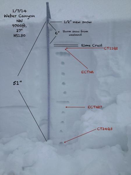
JG sent in this pit from Weber Canyon. Click here for current winds, temperatures, and snowfall throughout the range. Click here for trip reports and avalanche observations.
|
 |
recent activity
Sunday's wind and fresh snow created a few drifts along the leeward side of upper elevation ridges. Here, Johnny and Bob inspect a fresh wind slab on a stunningly brilliant day in upper Weber Canyon. |
| type | aspect/elevation | characteristics |
|---|

|

|
LIKELIHOOD
 LIKELY
UNLIKELY
SIZE
 LARGE
SMALL
TREND
 INCREASING DANGER
SAME
DECREASING DANGER
|
|
description
Yesterday's wind found enough snow to blow around and form a few fresh drifts, but I think the vast majority of these will be shallow and limited to upper elevation, leeward slopes. Predictably breaking at or below your skis, board, or sled, today's drifts will appear fat and rounded and are easy to detect and avoid.
|
| type | aspect/elevation | characteristics |
|---|

|

|
LIKELIHOOD
 LIKELY
UNLIKELY
SIZE
 LARGE
SMALL
TREND
INCREASING DANGER
SAME
DECREASING DANGER
|
|
description
The last avalanche breaking to old snow near the ground occurred the day after Christmas, but that doesn't mean the deeper issues within our snowpack have gone away and life is good. It does mean that in most areas the snowpack is comfortable in its own skin or the slab has been gobbled up by the facets in the mid portion of our pack. However, the western Uinta's are a big place and I still think our usual suspects- steep, rocky, upper elevation slopes facing the north half of the compass- remain questionable. This is the type of terrain where you could trigger a slide that breaks deeper and wider than you might expect.
|
 |
weather Snow should continue through the day with accumulations in the 2"-4" range. West and southwest winds remain reasonable and in the 15-25 mph range. Temperatures reach into the mid and upper 20's with overnight lows in the teens. Snow tapers off tonight, but ramps back up again on Thursday with a better shot of snow expected Thursday night, A break for Friday and then strong winds proceed a better looking storm slated for late Saturday and Sunday.
|
| general announcements Remember your information can save lives. If you see anything we should know about, please participate in the creation of our own community avalanche advisory by submitting snow and avalanche conditions. You can call me directly at 801-231-2170, email [email protected], or email by clicking HERE This is a great time of year to schedule a free avalanche awareness presentation for your group or club. You can contact me at 801-231-2170 or email [email protected] Donate to your favorite non-profit –The Utah Avalanche Center. The UAC depends on contributions from users like you to support our work. Benefit the Utah Avalanche Center when you buy or sell on ebay - set the Utah Avalanche Center as a favorite non-profit in your ebay account here and click on ebay gives when you buy or sell. You can choose to have your seller fees donated to the UAC, which doesn't cost you a penny. Utah Avalanche Center mobile app - Get your advisory on your iPhone along with great navigation and rescue tools. The information in this advisory is from the US Forest Service which is solely responsible for its content. This advisory describes general avalanche conditions and local variations always occur. I will update this advisory by 7:00 AM on Saturday Jan. 11, 2014 |


_0.jpg)