| During the month of April, Mark Miller will donate $75 to the charity of your choice (5 to chose from, including the Utah Avalanche Center!) Mark Miller Subaru has raised over $300k in the previous 6 Do Good Feel Good events. More Info here |  |
| During the month of April, Mark Miller will donate $75 to the charity of your choice (5 to chose from, including the Utah Avalanche Center!) Mark Miller Subaru has raised over $300k in the previous 6 Do Good Feel Good events. More Info here | |
| Advisory: Uintas Area Mountains | Issued by Craig Gordon for Sunday - December 29, 2013 - 5:49am |
|---|

|
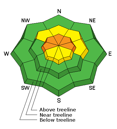
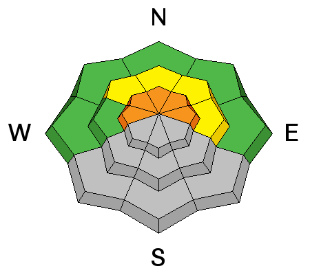
bottom line Terrain to avoid- steep, upper elevation slopes facing the north half of the compass, where pockets of CONSIDERABLE avalanche danger exist and human triggered avalanches are likely. Once initiated, today's avalanches will break deep and wide creating an unmanageable and dangerous slide. A few, fresh wind drifts developed overnight on upper elevation south facing slopes and a MODERATE avalanche danger exists. While not widespread, human triggered avalanches are possible on steep, wind drifted, slopes. If you're looking for go to terrain, head to low elevation slopes or terrain facing the south half of the compass where the avalanche danger is generally LOW..
|
 |
special announcement The Utah Avalanche Center wishes you a safe and powder-filled holiday season. Please consider the UAC in your holiday giving plans - your donations pay for these advisories and we can't do this without your help. What is it worth to you every day to get an avalanche and mountain weather advisory? The cost of a beverage or the gas it takes to get up the canyon? You can donate here. Give the gift of STOKE! There are still a few slots open for our Avalanche and Riding Skills Workshop with Boondockers. Click here for more info. |
 |
current conditions A moisture starved cold front slid through the region overnight giving us a light dusting of snow. Skies cleared late last night and temperatures crashed into the single digits. Northeast winds increased into the mid 30's for a few hours, but have been steadily decreasing and are currently blowing 10-20 mph. Riding and turning conditions remain quite good on wind sheltered mid elevation slopes. Click here for current winds, temperatures, and snowfall throughout the range. Click here for trip reports and avalanche observations.
|
 |
recent activity
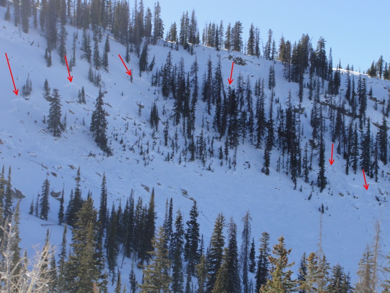
Ted found these couple of pockets in Murdock Bowl during his travels up Mirror Lake Highway yesterday (his trip report can be found here). In addition, he spotted a recent avalanche on Double Hill on his way home and will scope that out today. Otherwise no news of the weird. |
| type | aspect/elevation | characteristics |
|---|

|
|
LIKELIHOOD
 LIKELY
UNLIKELY
SIZE
 LARGE
SMALL
TREND
 INCREASING DANGER
SAME
DECREASING DANGER
|
|
description
The snowpack continues to adjust to the Christmas Eve storm and the possibility of triggering avalanches diminishes. That's the good news. The bad news is... the avalanches we do trigger are just as scary and will break wider and deeper than we expect. The persistent weakness buried in the mid portion of our snowpack and the weak, sugary snow near the ground isn't going away anytime soon. We can't change the snowpack, but we can change the terrain we choose to ride in. Steep, upper elevation slopes facing the north half of the compass remain sketchy. Given the shallow snowpack conditions right now, an avalanche that breaks to the ground will take you for a body beating ride through rocks and stumps barely hidden under this thin veil of snow. If you wanna get on steep terrain, get out in the sun on south facing slopes where the snowpack is stronger and more consolidated, and the avalanche danger is manageable.
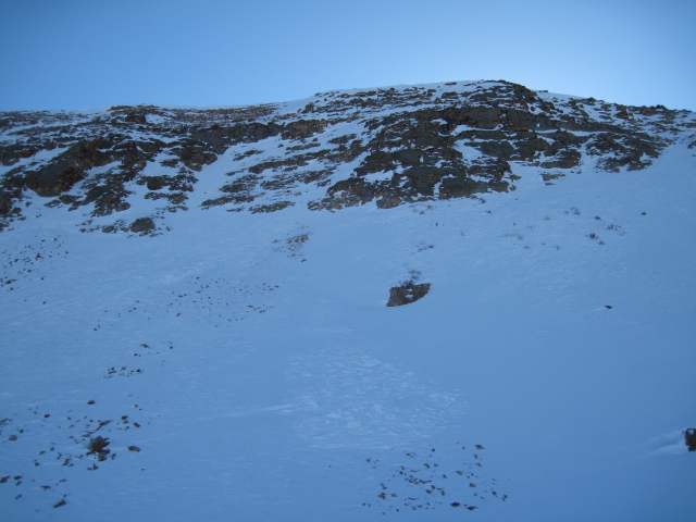
Michael Janulaitus found this avalanche near Duke Peak Friday. This is the type of terrain where you could trigger an avalanche today.
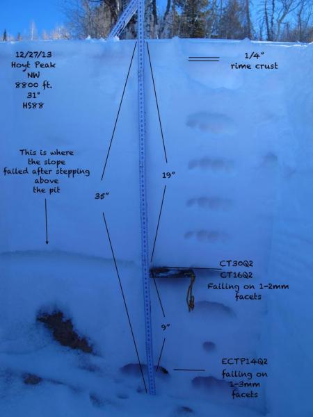
Here's a great ob from JG, clearly illustrating our snowpack setup.
|
 |
weather Pretty quiet in this department. Mostly sunny skies are on tap for today with winds switching to the northwest and remaining in the 10-20 mph range. Temperatures climb into the low 20's before diving to near zero tonight. Increasing clouds for late Monday as a weak storm grazes the region and light snow falls Tuesday. High pressure builds for the remainder of the week with a glimmer of hope for a storm next weekend.
|
| general announcements Remember your information can save lives. If you see anything we should know about, please participate in the creation of our own community avalanche advisory by submitting snow and avalanche conditions. You can call me directly at 801-231-2170, email [email protected], or email by clicking HERE This is a great time of year to schedule a free avalanche awareness presentation for your group or club. You can contact me at 801-231-2170 or email [email protected] Donate to your favorite non-profit –The Utah Avalanche Center. The UAC depends on contributions from users like you to support our work. Benefit the Utah Avalanche Center when you buy or sell on ebay - set the Utah Avalanche Center as a favorite non-profit in your ebay account here and click on ebay gives when you buy or sell. You can choose to have your seller fees donated to the UAC, which doesn't cost you a penny. Utah Avalanche Center mobile app - Get your advisory on your iPhone along with great navigation and rescue tools. The information in this advisory is from the US Forest Service which is solely responsible for its content. This advisory describes general avalanche conditions and local variations always occur. I will update this advisory by 7:00 AM on Wednesday Jan. 1, 2014 |


_0.jpg)