| During the month of April, Mark Miller will donate $75 to the charity of your choice (5 to chose from, including the Utah Avalanche Center!) Mark Miller Subaru has raised over $300k in the previous 6 Do Good Feel Good events. More Info here |  |
| During the month of April, Mark Miller will donate $75 to the charity of your choice (5 to chose from, including the Utah Avalanche Center!) Mark Miller Subaru has raised over $300k in the previous 6 Do Good Feel Good events. More Info here | |
| Advisory: Uintas Area Mountains | Issued by Craig Gordon for Wednesday - December 25, 2013 - 7:01am |
|---|

|
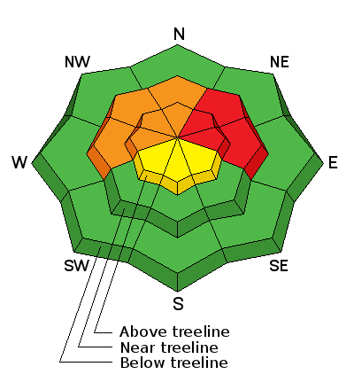
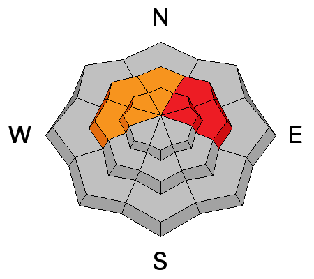
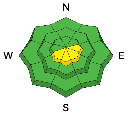
bottom line Terrain to avoid- steep, mid and upper elevation slopes facing the north half of the compass, particularly those with an easterly component to their aspect, where a HIGH avalanche danger exists and human triggered avalanches are very likely. A CONSIDERABLE avalanche danger is found on upper elevation shady slopes and human triggered avalanches are likely. In either case, once initiated, today's avalanches will break deep and wide creating an unmanageable and dangerous slide. Upper elevation south facing terrain offers a MODERATE avalanche danger and human triggered avalanches are possible on steep wind drifted slopes. If you're looking for LOW avalanche danger, head to low elevation terrain or slopes facing the south half of the compass which had very little snow prior to last Thursday's big storm
|
 |
special avalanche bulletin HUMAN TRIGGERED AVALANCHES LIKELY IN MANY AREAS OF NORTHERN UTAH. The combination of recent snow resting on pre-existing weak layers has created unstable avalanche conditions. Beautiful weather and lot's of people heading into the mountains during the holidays during these dangerous avalanche conditions is just the recipe for an accident. Keep off of and out from underneath steep slopes that face west through north through east. |
 |
special announcement The Utah Avalanche Center wishes you a safe and powder-filled holiday season. Please consider the UAC in your holiday giving plans - your donations pay for these advisories and we can't do this without your help. What is it worth to you every day to get an avalanche and mountain weather advisory? The cost of a beverage or the gas it takes to get up the canyon? You can donate here. Looking for a stocking stuffer? Give the gift of STOKE! There are still a few slots open for our Avalanche and Riding Skills Workshop with Boondockers. Click here for more info. |
 |
current conditions Bruce and I wish everyone a Merry Christmas! A nice shot of snow slid through the area early yesterday morning, stacking up 3"-5" of dense, creamy snow, helping to cushion Monday's rime crust. Skies cleared overnight and current temperatures are in the single digits and low teens. A bit of a game changer are the west and northwest winds which have been blowing steadily in the 20's and 30's with gusts to 50 mph since early Tuesday. Riding and turning conditions are quite good in wind sheltered terrain at mid and lower elevations. Click here for current winds, temperatures, and snowfall throughout the range. Click here for trip reports and avalanche observations.
|
 |
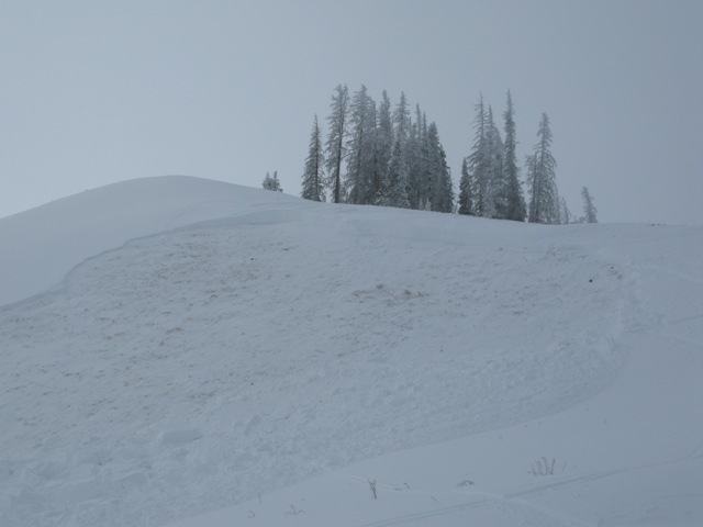
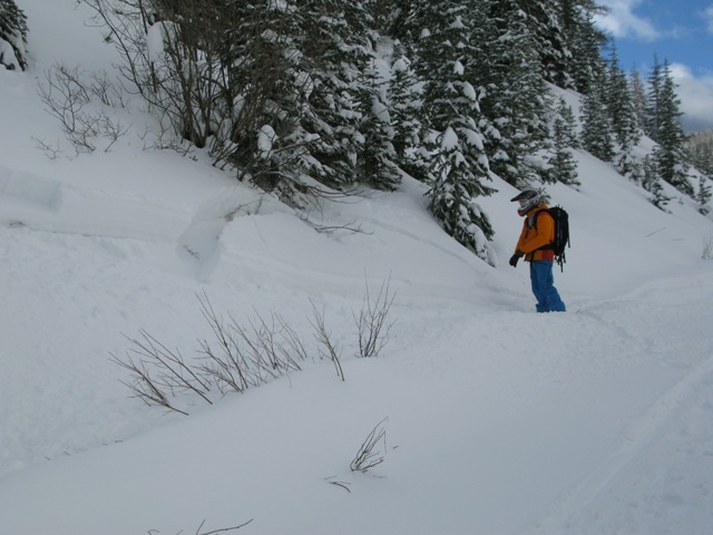
recent activity Avalanches are breaking deep and wide.
Trent and I went to our favorite test slope near Currant Creek Peak and remotely triggered this slide which broke 3'-5' deep and 150' wide, failing on old snow near the ground. Check out Trent's great viddy describing the setup.
The slide was triggered while the rider was sidehilling low on the slope of a Northeast aspect in the Super Bowl.
|
| type | aspect/elevation | characteristics |
|---|

|
|
LIKELIHOOD
 LIKELY
UNLIKELY
SIZE
 LARGE
SMALL
TREND
 INCREASING DANGER
SAME
DECREASING DANGER
|
|
description
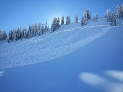
Yesterdays wind changed both the landscape and the avalanche danger, leading to an active day on the eastern front with several human triggered slides breaking to mid pack facets and old snow near the ground. Not much has changed overnight and we've got a sketchy structure to our snowpack, particularly on mid and upper elevation slopes facing the north half of the compass. Making matters more complicated is you can trigger avalanches from a distance or while you're low on slope. Steep leeward slopes with an easterly component, especially those in the wind zone, are right in the bullseye of the avalanche dragon sights today. This is the type of terrain that needs to be avoided, because if we do trigger an avalanche it will get out of hand very quickly, breaking wide and deep, taking out the entire seasons snowpack, and creating an unmanageably dangerous slide.. Wanna shred steep terrain? Head to mid elevation slopes facing the south half of the compass which had very little old snow prior to last weeks big storm and in many cases storm snow fell on bare ground. This is go to terrain for today.
|
| type | aspect/elevation | characteristics |
|---|

|
|
LIKELIHOOD
 LIKELY
UNLIKELY
SIZE
 LARGE
SMALL
TREND
 INCREASING DANGER
SAME
DECREASING DANGER
|
|
description
North and northwest winds had plenty of snow to work with yesterday, rapidly forming sensitive wind drifts on upper elevation slopes facing the south half of the compass. Mostly manageable because they break at or below our skis, board, or sled, they did form on a variety of slick, hard, old snow surfaces. While slope cuts are a good defensive measure with this type of avalanche problem, remember that in steep, sustained terrain, even a small piece of snow could take you for an unexpected, knee tweaking ride. |
 |
weather Not much going on in the weather department. A building ridge leads to sunny skies, gradually warming temperatures, and light winds, through the end of the week. High temperatures climb into the mid 30's with overnight lows dipping into the teens.
|
| general announcements Remember your information can save lives. If you see anything we should know about, please participate in the creation of our own community avalanche advisory by submitting snow and avalanche conditions. You can call me directly at 801-231-2170, email [email protected], or email by clicking HERE This is a great time of year to schedule a free avalanche awareness presentation for your group or club. You can contact me at 801-231-2170 or email [email protected] Donate to your favorite non-profit –The Utah Avalanche Center. The UAC depends on contributions from users like you to support our work. Benefit the Utah Avalanche Center when you buy or sell on ebay - set the Utah Avalanche Center as a favorite non-profit in your ebay account here and click on ebay gives when you buy or sell. You can choose to have your seller fees donated to the UAC, which doesn't cost you a penny. Utah Avalanche Center mobile app - Get your advisory on your iPhone along with great navigation and rescue tools. The information in this advisory is from the US Forest Service which is solely responsible for its content. This advisory describes general avalanche conditions and local variations always occur. I will update this advisory by 7:00 AM on Thursday Dec. 26, 2013 |


_0.jpg)