| During the month of April, Mark Miller will donate $75 to the charity of your choice (5 to chose from, including the Utah Avalanche Center!) Mark Miller Subaru has raised over $300k in the previous 6 Do Good Feel Good events. More Info here |  |
| During the month of April, Mark Miller will donate $75 to the charity of your choice (5 to chose from, including the Utah Avalanche Center!) Mark Miller Subaru has raised over $300k in the previous 6 Do Good Feel Good events. More Info here | |
| Advisory: Uintas Area Mountains | Issued by Craig Gordon for Monday - December 23, 2013 - 6:13am |
|---|

|
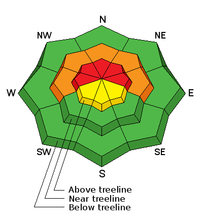
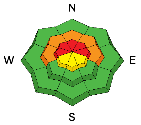
bottom line Terrain to avoid- steep, upper elevation slopes in the wind zone, particularly those facing the north half of the compass, where a HIGH avalanche danger exists and human triggered avalanches are very likely. Once initiated, today's avalanches will break deep and wide creating an unmanageable and dangerous slide. While not as widespread, a CONSIDERABLE avalanche danger is found in mid elevation shady terrain and human triggered avalanches are likely on steep wind drifted slopes. If you're looking for LOW avalanche danger, head to low elevation terrain or slopes facing the south half of the compass which had very little snow prior to last Thursday's big storm
|
 |
special avalanche bulletin THIS SPECIAL AVALANCHE ADVISORY IS FOR THE MOUNTAINS OF NORTHERN UTAH. A HIGH AVALANCHE DANGER EXISTS FOR MOST MOUNTAIN AREAS OF NORTHERN UTAH. BACKCOUNTRY TRAVEL IS NOT RECOMMENDED. THIS ADVISORY DOES NOT INCLUDE SKI AREAS OR HIGHWAYS WHERE AVALANCHE CONTROL IS NORMALLY DONE. |
 |
special announcement The Utah Avalanche Center wishes you a safe and powder-filled holiday season. Please consider the UAC in your holiday giving plans - your donations pay for these advisories and we can't do this without your help. What is it worth to you every day to get an avalanche and mountain weather advisory? The cost of a beverage or the gas it takes to get up the canyon? You can donate here. Looking for a stocking stuffer? Give the gift of STOKE! There are still a few slots open for our Avalanche and Riding Skills Workshop with Boondockers. Click here for more info. |
 |
current conditions Light snow continues this morning and it looks like most areas received 3"-5" of snow since yesterday morning. Storm totals since last Thursday are close to two feet with just over 1.5" of water. West and northwest winds increased early Sunday morning and have been blowing steadily in the 20's and 30's along the ridges. Temperatures are in the mid teens at most locations and in the single digits along the high ridges. Mid and low elevation wind sheltered terrain remains the hot ticket for good riding and turning conditions. Click here for current winds, temperatures, and snowfall throughout the range. Click here for trip reports and avalanche observations.
|
 |
recent activity
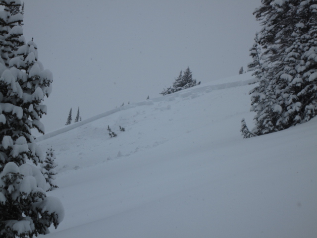
Our main man Ted Scroggin was able to remotely trigger this slab from about 200' away from a low angle portion of the slope. Click here for his expert take on the snowpack.
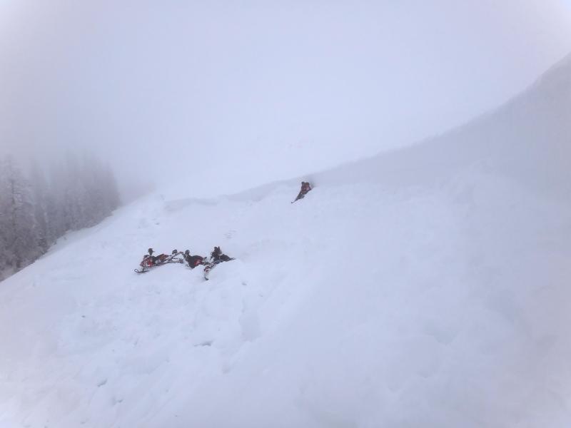
A sled triggered slide near Lake Creek Friday, broke to old snow near the ground. Fortunately, quick reaction time and a successful airbag deployment lead to a happy outcome with this rider coming out on top of the debris. Here's a first hand account- " I was sidehilling when the avalanche broke above me. It took me off my sled and within two seconds it completely came over my head and I immediately pulled the rip cord and within two seconds my head and shoulders were out of the snow but my waist and legs were trapped."
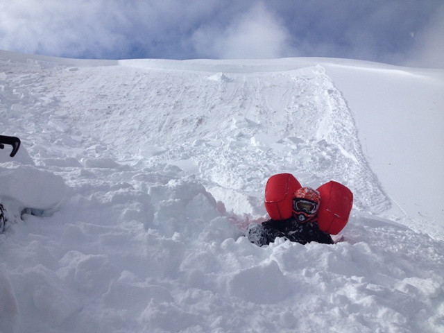
Tyler, Kirk, and Kam from Wasatch County S&R visiting the site yesterday. Check out their excellent investigation which you can view here. Many thanks guys... you rock!
|
| type | aspect/elevation | characteristics |
|---|

|
|
LIKELIHOOD
 LIKELY
UNLIKELY
SIZE
 LARGE
SMALL
TREND
 INCREASING DANGER
SAME
DECREASING DANGER
|
|
description
The weak layers in the mid portion of our snowpack are slow to heal and not much has changed since yesterday's advisory was published. Sure, there are plenty of slopes you can ride today and not trigger an avalanche. However, if your travels take you onto steep, rocky, upper elevation slopes, especially those that face the north half of the compass, you'll be in the avalanche dragon's bullseye today. This is exactly the type of terrain where the mid portion of our snowpack is very weak and fragile and these are the kind of conditions where most avalanche accidents occur because the snow we're riding on feels strong and solid. It allows us to get well out onto the slope before we collapse the hill (whoomph), trigger the slab (shooting crack), and now we're staring down a dangerous slide that's breaking deeper and wider than we expected, taking out the entire seasons snowpack as the avalanche slams us into rocks and trees (season ending injury or worse).
Here, Trent points to the culprit- a layer of midpack facets formed during the very cold spell the first week of December.
|
 |
weather Mostly cloudy skies and light snow over the region today with west and northwest winds gusting into the 40's along the ridgetops. Temperatures rise into the mid 20's before dipping into the teens and single digits overnight. A cold front with limited moisture slides through the area tonight and in its wake, high pressure begins to build through the end of the week, bringing clear skies and warming temperatures.
|
| general announcements Remember your information can save lives. If you see anything we should know about, please participate in the creation of our own community avalanche advisory by submitting snow and avalanche conditions. You can call me directly at 801-231-2170, email [email protected], or email by clicking HERE This is a great time of year to schedule a free avalanche awareness presentation for your group or club. You can contact me at 801-231-2170 or email [email protected] Donate to your favorite non-profit –The Utah Avalanche Center. The UAC depends on contributions from users like you to support our work. Benefit the Utah Avalanche Center when you buy or sell on ebay - set the Utah Avalanche Center as a favorite non-profit in your ebay account here and click on ebay gives when you buy or sell. You can choose to have your seller fees donated to the UAC, which doesn't cost you a penny. Utah Avalanche Center mobile app - Get your advisory on your iPhone along with great navigation and rescue tools. The information in this advisory is from the US Forest Service which is solely responsible for its content. This advisory describes general avalanche conditions and local variations always occur. I will update this advisory by 7:00 AM on Tuesday Dec. 24, 2013 |


_0.jpg)