
| During the month of April, Mark Miller will donate $75 to the charity of your choice (5 to chose from, including the Utah Avalanche Center!) Mark Miller Subaru has raised over $300k in the previous 6 Do Good Feel Good events. More Info here |  |
| During the month of April, Mark Miller will donate $75 to the charity of your choice (5 to chose from, including the Utah Avalanche Center!) Mark Miller Subaru has raised over $300k in the previous 6 Do Good Feel Good events. More Info here | |
| Advisory: Uintas Area Mountains | Issued by Craig Gordon for Friday - December 20, 2013 - 6:11am |
|---|

|
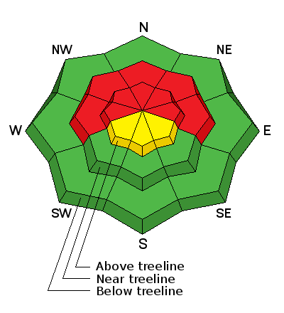
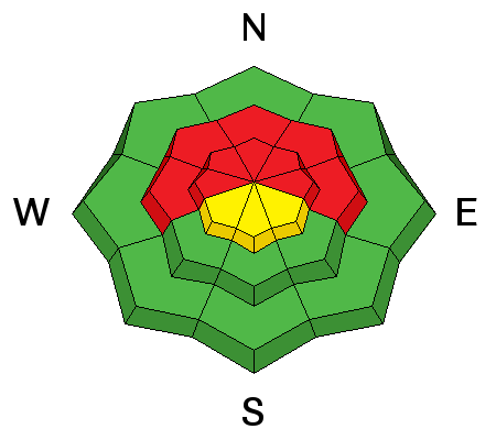
bottom line In the wind zone, a HIGH avalanche danger exists on steep, mid and upper elevation slopes, particularly those facing the north half of the compass, and human triggered avalanches are likely. Once triggered, today's avalanches will break deep and wide creating an unmanageable and dangerous slide. A MODERATE avalanche danger is found on upper elevation south facing terrain and human triggered avalanches are possible on any steep, wind drifted slope. Wind sheltered low elevation terrain offers LOW avalanche danger.
|
 |
special avalanche bulletin THIS SPECIAL AVALANCHE ADVISORY IS FOR THE MOUNTAINS OF NORTHERN UTAH TO INCLUDE THE WESTERN UINTAS. DANGEROUS HUMAN TRIGGERED AVALANCHES MAY BE TRIGGERED IN STEEP WEST TO NORTH TO EAST FACING TERRAIN ABOVE 8000` IN ELEVATION. EXPERT ROUTE-FINDING IS REQUIRED FOR SAFE TRAVEL IN THE MOUNTAINS. THIS SPECIAL AVALANCHE ADVISORY WILL CONTINUE THROUGH THE WEEKEND. THIS ADVISORY DOES NOT INCLUDE SKI AREAS OR HIGHWAYS WHERE AVALANCHE CONTROL IS NORMALLY DONE. |
 |
current conditions Yesterday's storm materialized nicely for the Uinta's delivering a much needed coat of new paint. Storm totals are pretty evenly disbursed with a solid 10" of dense snow stacking up throughout the range. Winds have mellowed and are currently blowing 5-15 mph along the high ridges. Under partly cloudy skies, temperatures are in the single digits and mid teens. The riding and turning conditions have gone from zero to hero... it's over the hood and in your face, particularly in wind sheltered terrain. Click here for current winds, temperatures, and snowfall throughout the range. Click here for trip reports and avalanche observations.
|
 |
recent activity Visibility was pretty limited Thursday and we couldn't see much. However, even before the big storm hit, Ted spotted a snowmobile triggered hard slab Wednesday on Yamaha Hill, breaking to the ground mid slope, about 2.5 ft deep and 150 ft wide.
|
| type | aspect/elevation | characteristics |
|---|

|
|
LIKELIHOOD
 LIKELY
UNLIKELY
SIZE
 LARGE
SMALL
TREND
 INCREASING DANGER
SAME
DECREASING DANGER
|
|
description
This was a good storm for the eastern front but don't get fooled by the couple of inches of light goodness the last half of the storm laid down. Underneath this fluff is a dense cohesive slab, and it's resting on a very weak snowpack, especially on mid and upper elevation slopes facing the north half of the compass. These are the kind of conditions where most avalanche accidents occur because the snow we're riding on feels strong and solid, but we've gotta remember it's sitting on top of some bad mojo. While I think many steep, shady slopes throughout the range avalanched naturally during the storm, there are plenty of slopes that remain in the balance, just waiting for a trigger to come along and knock the legs out from underneath. What's going to make things more tricky today is, you'll be able to trigger avalanches from a distance and on relatively flat terrain, so you need to consider what type of terrain is above and adjacent to where you're riding. Once triggered, avalanches will break deep and wide and have the possibility of releasing the entire seasons snowpack, creating a large and dangerous avalanche. Today you'll need to tone down your objectives and think about the consequences of triggering a slide. It doesn't mean you can't ride. In fact, you can have a blast on low angle slopes with no steep terrain above or adjacent to where you're riding.
|
 |
weather Mostly cloudy skies and a few lingering snow showers continue this morning, but in general we should see a break in the action before the next system arrives tonight. Westerly winds ramp up into the 30's and 40's late in the day and temperatures climb into the mid 20's before dipping into the teens overnight. Moisture spreads into the area tonight, bringing a period of heavy snowfall before the storm winds down tomorrow night. Storm totals look to be in the 6"-8" range with light snow showers sticking around through Sunday.
|
| general announcements Remember your information can save lives. If you see anything we should know about, please participate in the creation of our own community avalanche advisory by submitting snow and avalanche conditions. You can call me directly at 801-231-2170, email [email protected], or email by clicking HERE This is a great time of year to schedule a free avalanche awareness presentation for your group or club. You can contact me at 801-231-2170 or email [email protected] Donate to your favorite non-profit –The Utah Avalanche Center. The UAC depends on contributions from users like you to support our work. Benefit the Utah Avalanche Center when you buy or sell on ebay - set the Utah Avalanche Center as a favorite non-profit in your ebay account here and click on ebay gives when you buy or sell. You can choose to have your seller fees donated to the UAC, which doesn't cost you a penny. Utah Avalanche Center mobile app - Get your advisory on your iPhone along with great navigation and rescue tools. The information in this advisory is from the US Forest Service which is solely responsible for its content. This advisory describes general avalanche conditions and local variations always occur. I will update this advisory by 7:00 AM on Saturday Dec. 21, 2013 |


_0.jpg)