
| During the month of April, Mark Miller will donate $75 to the charity of your choice (5 to chose from, including the Utah Avalanche Center!) Mark Miller Subaru has raised over $300k in the previous 6 Do Good Feel Good events. More Info here |  |
| During the month of April, Mark Miller will donate $75 to the charity of your choice (5 to chose from, including the Utah Avalanche Center!) Mark Miller Subaru has raised over $300k in the previous 6 Do Good Feel Good events. More Info here | |
| Advisory: Uintas Area Mountains | Issued by Craig Gordon for Thursday - December 19, 2013 - 7:16am |
|---|

|
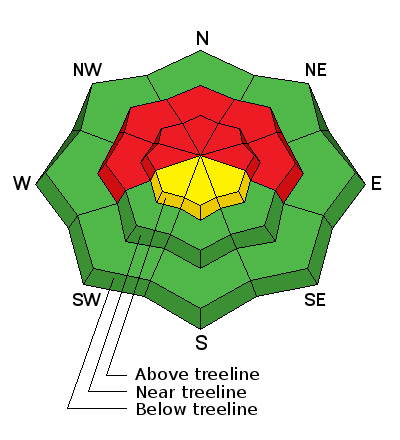
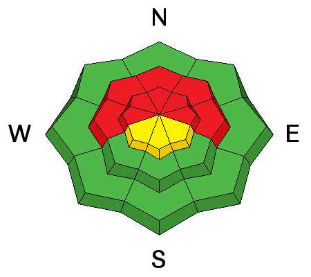
bottom line In the wind zone, a HIGH avalanche danger exists on steep, mid and upper elevation, north facing slopes, both natural and human triggered avalanches are likely. Once triggered, today's avalanches will break deep and wide creating an unmanageable and dangerous slide. A MODERATE avalanche danger is found on upper elevation south facing terrain and human triggered avalanches are possible on any steep, wind drifted slope. Wind sheltered low elevation terrain offers LOW avalanche danger.
|
 |
special avalanche bulletin Dangerous avalanche conditions have materialized overnight. Both natural and human triggered avalanches are likely on steep wind drifted slopes, especially in mid and upper elevation terrain facing the north half of the compass. |
 |
current conditions A nice shot of snow and water moved in to the region overnight. Most areas received 6-8" of dense, heavy snow with close to an inch of water. Southwest winds are blowing in the 35-50 mph along the high ridges and temperatures are in the high 20's and low 30's. Click here for current winds, temperatures, and snowfall throughout the range. Click here for trip reports and avalanche observations.
|
 |
recent activity One sled triggered hard slab Ted spotted yesterday on Yamaha Hill, breaking to the ground mid slope, about 2.5 ft deep and 150 ft wide. |
| type | aspect/elevation | characteristics |
|---|

|
|
LIKELIHOOD
 LIKELY
UNLIKELY
SIZE
 LARGE
SMALL
TREND
 INCREASING DANGER
SAME
DECREASING DANGER
|
|
description
This is a good storm for the eastern front but it isn't the light, fluffy snow we're known for on our license plates. Nope, it's dense and heavy, it's falling on a very weak snowpack, and it's going to create dangerous avalanche conditions. Yesterday I was surprised at just how weak the snowpack has grown in just a few days. Here it is nearly Christmas and total snow depths throughout the range only average about two feet or so... that's pretty grim considering the time of year. As we all know, shallow snow is weak snow and in much of terrain the snow structure has the consistency of rock salt and we're riding on the ground. In general avalanche conditions have been pretty benign, but overnight things have changed. Strong winds have formed a dense, cohesive slab on top of this weak sugary mess and avalanche conditions will be tricky today. You'll be able to trigger avalanches from a distance and on relatively flat terrain and today's slides will break deeper and wider than you might expect. Today you'll need to tone down your objectives and think about the consequences of triggering a slide. It doesn't mean you can't ride. In fact, you can have a blast on low angle slopes with no steep terrain above or adjacent to where you're riding.
|
 |
weather We can expect snow to continue throughout the morning with an additional 2"-4" possible. Southwest winds blow in the 30's before tapering off as the day wares on. High temperatures don't vary much from where we're at this morning and then dip into the teens overnight. A break on Friday with another system on tap for Saturday.
|
| general announcements Remember your information can save lives. If you see anything we should know about, please participate in the creation of our own community avalanche advisory by submitting snow and avalanche conditions. You can call me directly at 801-231-2170, email [email protected], or email by clicking HERE This is a great time of year to schedule a free avalanche awareness presentation for your group or club. You can contact me at 801-231-2170 or email [email protected] Donate to your favorite non-profit –The Utah Avalanche Center. The UAC depends on contributions from users like you to support our work. Benefit the Utah Avalanche Center when you buy or sell on ebay - set the Utah Avalanche Center as a favorite non-profit in your ebay account here and click on ebay gives when you buy or sell. You can choose to have your seller fees donated to the UAC, which doesn't cost you a penny. Utah Avalanche Center mobile app - Get your advisory on your iPhone along with great navigation and rescue tools. The information in this advisory is from the US Forest Service which is solely responsible for its content. This advisory describes general avalanche conditions and local variations always occur. I will update this advisory by 7:00 AM on Friday Dec. 20, 2013 |


_0.jpg)