| During the month of April, Mark Miller will donate $75 to the charity of your choice (5 to chose from, including the Utah Avalanche Center!) Mark Miller Subaru has raised over $300k in the previous 6 Do Good Feel Good events. More Info here |  |
| During the month of April, Mark Miller will donate $75 to the charity of your choice (5 to chose from, including the Utah Avalanche Center!) Mark Miller Subaru has raised over $300k in the previous 6 Do Good Feel Good events. More Info here | |
| Advisory: Uintas Area Mountains | Issued by Craig Gordon for Wednesday - December 11, 2013 - 5:30am |
|---|

|
bottom line In the wind zone, a CONSIDERABLE avalanche danger will be found on steep, wind drifted slopes and human triggered avalanches are likely. Terrain to avoid is steep, rocky, leeward slopes, especially where solid feeling slabs overlay weak sugary snow near the ground. In terrain with these characteristics avalanches have the possibility to break wide and deep, creating an unmanageably large and dangerous slide. At mid elevations, a MODERATE avalanche danger exists on steep wind drifted slopes and human triggered avalanches are possible. Low elevation terrain and slopes slopes facing the south half of the compass offer LOW avalanche danger.
|
 |
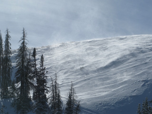
current conditions High pressure is firmly entrenched over the region, giving us clear skies and slightly warmer temperatures in the low teens. After a spike in winds yesterday with gusts in the 50's along the high ridges, it's pretty mellow this morning and southwesterly winds are blowing 10-20 mph. Yesterday's wind changed the upper elevation landscape, wrecking a lot of good snow in the big open bowls, but you can still find soft settled snow in mid elevation, wind sheltered terrain.
Tuesday's winds had their way along the high ridges and wind exposed terrain. Click here for current winds, temperatures, and snowfall throughout the range. Click here for trip reports and avalanche observations.
|
 |
recent activity
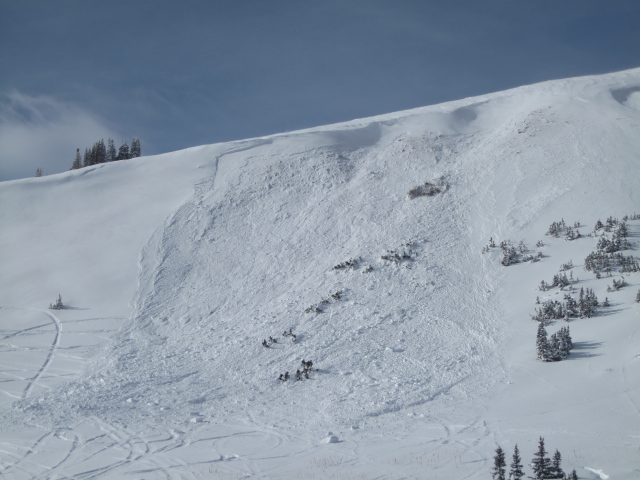
With plenty of snow to work with and a spike in the winds late Sunday, this natural avalanche probably occurred in the Sunday/Monday timeframe. It's a decent chunk of snow, breaking to the ground.
I came across this sled triggered slab on Tower Mountain. Not huge, but breaking to weak snow near the ground... no bueno.
Yesterday, Ted found this slide on Double Hill which looks like it was triggered low on the slope. Same deal, different slope... breaking to weak snow near the ground. |
| type | aspect/elevation | characteristics |
|---|

|

|
LIKELIHOOD
 LIKELY
UNLIKELY
SIZE
 LARGE
SMALL
TREND
 INCREASING DANGER
SAME
DECREASING DANGER
|
|
description
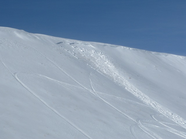
West and southwest winds were cranking on Tuesday, rapidly forming fresh drifts on leeward slopes in the wind zone and also getting into mid elevation terrain as well. Yesterdays slabs most likely relaxed a bit overnight and probably won't be quite as sensitive today. Problem is, the snow surface will feel strong and good to go, but it's not what we're riding in that we need to focus on, it's what we're riding on, and there's no shortage of weak sugary snow near the ground. This is a tricky setup because we can ride plenty of slopes without incident which lures us into bigger terrain. However, all we need to do is find a weakness in the snowpack (usually a thin spot around rocks poking through the snow), collapse the slope (whoomph), and then things can get quickly out of hand as the avalanche we just triggered drags us through rocks and stumps barely hidden under our relatively shallow snow cover. This setup is most prevalent on mid and upper elevation slopes facing the north half of the compass, especially in terrain that's steep and rocky.
|
 |
weather Clear skies, warming temperatures, and light winds are on tap the next few days as high pressure takes control of our weather pattern. Westerly winds will be in the 10-20 mph range along the high ridges, daytime highs climb into the mid 20's and overnight lows dip into the low teens. A weak cold front pushes a few clouds and a flurry or two into the region on Friday, before a dry stable flow returns for the weekend. Perhaps a glimmer of hope for a storm next week at this time.
|
| general announcements Remember your information can save lives. If you see anything we should know about, please participate in the creation of our own community avalanche advisory by submitting snow and avalanche conditions. You can call me directly at 801-231-2170, email [email protected], or email by clicking HERE This is a great time of year to schedule a free avalanche awareness presentation for your group or club. You can contact me at 801-231-2170 or email [email protected] Donate to your favorite non-profit –The Utah Avalanche Center. The UAC depends on contributions from users like you to support our work. Benefit the Utah Avalanche Center when you buy or sell on ebay - set the Utah Avalanche Center as a favorite non-profit in your ebay account here and click on ebay gives when you buy or sell. You can choose to have your seller fees donated to the UAC, which doesn't cost you a penny. Utah Avalanche Center mobile app - Get your advisory on your iPhone along with great navigation and rescue tools. The information in this advisory is from the US Forest Service which is solely responsible for its content. This advisory describes general avalanche conditions and local variations always occur. I will update this advisory by 7:00 AM on Saturday Dec. 14, 2013 |


_0.jpg)