| During the month of April, Mark Miller will donate $75 to the charity of your choice (5 to chose from, including the Utah Avalanche Center!) Mark Miller Subaru has raised over $300k in the previous 6 Do Good Feel Good events. More Info here |  |
| During the month of April, Mark Miller will donate $75 to the charity of your choice (5 to chose from, including the Utah Avalanche Center!) Mark Miller Subaru has raised over $300k in the previous 6 Do Good Feel Good events. More Info here | |
| Advisory: Uintas Area Mountains | Issued by Craig Gordon for Sunday - December 8, 2013 - 5:47am |
|---|


|
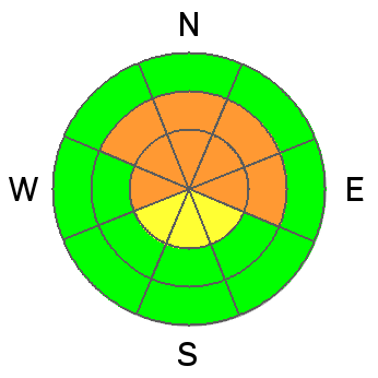
bottom line A CONSIDERABLE avalanche danger will be found on steep, wind drifted, mid and upper elevation slopes and human triggered avalanches are likely. Terrain to avoid is steep, rocky, leeward slopes, especially where solid feeling slabs overlay weak sugary snow near the ground. In terrain with these characteristics avalanches have the possibility to break wide and deep, creating an unmanageably large and dangerous slide. Upper elevation south facing terrain offers MODERATE avalanche danger and human triggered slides are possible on steep wind drifted slopes. Low elevation terrain and slopes that were bare prior to Tuesday's big storm offer a LOW avalanche danger.
|
 |
current conditions The storm was a bit of a bust for the north slope which only picked up 2" of very light density snow, whilst the south half of the range stacked up 6". In either case, winds are the great equalizer and they blew out of the southeast for most of Saturday, averaging 20-35 mph, before switching to the west and northwest around 10:00 last night and backing off into the teens. Under mostly cloudy skies, temperatures are near zero, though along the ridges they're still in negative territory. The riding and turning conditions are quite good, especially in mid and low elevation wind sheltered terrain. Click here for current winds, temperatures, and snowfall throughout the range.
Click here for trip reports and avalanche observations.
|
 |
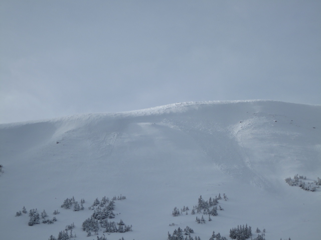
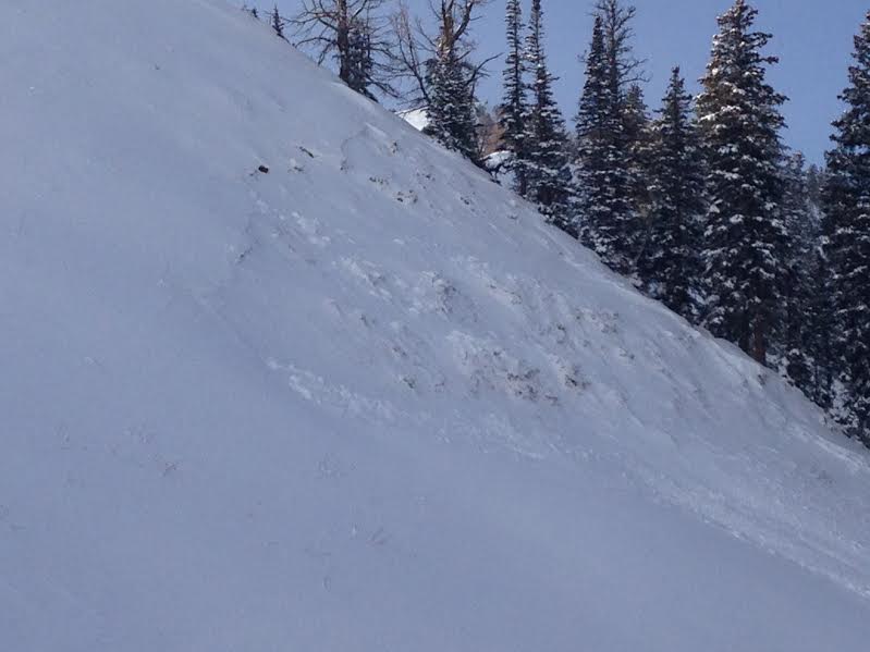
recent activity Two distinctly different avalanche dragons.
On Friday, Ted found these shallow wind slabs on Double Hill.
This slide is a result of Tuesday's storm. Not a big piece of snow, but a great indicator just how weak our snowpack is, especially in steep rocky terrain. |
| type | aspect/elevation | characteristics |
|---|

|
|
LIKELIHOOD
 LIKELY
UNLIKELY
SIZE
 LARGE
SMALL
TREND
 INCREASING DANGER
SAME
DECREASING DANGER
|
|
description
Winds were busy at work for most of Saturday, forming fresh drifts sensitive to the additional weight of a rider. Breaking at or below our skis, board, or sled, those are manageable avalanches. Not so manageable are slides that break close to the ground on old October snow. There are two distinct weaknesses in our snowpack and until yesterday's storm they lacked a key ingredient... a cohesive slab. Now all the players are aligned. Problem is, today's snow will feel strong and good to go, but it's not what we're riding in that we need to focus on, it's what we're riding on, and we've got plenty of weak sugary snow near the ground. This is a dangerous setup because we can ride plenty of slopes without incident which lures us into bigger terrain. Then all we need to do is find a weakness in the snowpack, collapse the slope, and now we're staring down the barrel of a dangerous slide that going to work us as we get dragged through rocks and stumps barely hidden under our relatively shallow snow cover. This setup is most prevalent on mid and upper elevation slopes facing the north half of the compass, especially in terrain that's steep and rocky.
Thanks to JG for this great snowpit illustration from Weber Canyon. Not much has changed with the basic snowpack structure since earlier in the week. Click here for a quick viddy explaining the setup.
|
 |
weather Snow showers continue through the day, but we'll be lucky to squeeze another inch or two out of this storm. Skies become partly cloudy and temperatures barely climb out of the low single digits. West and northwest winds blow 15-25 mph along the ridges, decreasing late in the day as the storm exits the region. Temperatures remain very cold Monday and Tuesday with a slight warming trend on tap for midweek. Much uncertainty in the forecast for the latter half of the week.
|
| general announcements Remember your information can save lives. If you see anything we should know about, please participate in the creation of our own community avalanche advisory by submitting snow and avalanche conditions. You can call me directly at 801-231-2170, email [email protected], or email by clicking HERE This is a great time of year to schedule a free avalanche awareness presentation for your group or club. You can contact me at 801-231-2170 or email [email protected] Donate to your favorite non-profit –The Utah Avalanche Center. The UAC depends on contributions from users like you to support our work. Benefit the Utah Avalanche Center when you buy or sell on ebay - set the Utah Avalanche Center as a favorite non-profit in your ebay account here and click on ebay gives when you buy or sell. You can choose to have your seller fees donated to the UAC, which doesn't cost you a penny. Utah Avalanche Center mobile app - Get your advisory on your iPhone along with great navigation and rescue tools. The information in this advisory is from the US Forest Service which is solely responsible for its content. This advisory describes general avalanche conditions and local variations always occur. I will update this advisory by 7:00 AM on Wednesday Dec. 11, 2013 |


_0.jpg)