| During the month of April, Mark Miller will donate $75 to the charity of your choice (5 to chose from, including the Utah Avalanche Center!) Mark Miller Subaru has raised over $300k in the previous 6 Do Good Feel Good events. More Info here |  |
| During the month of April, Mark Miller will donate $75 to the charity of your choice (5 to chose from, including the Utah Avalanche Center!) Mark Miller Subaru has raised over $300k in the previous 6 Do Good Feel Good events. More Info here | |
| Advisory: Uintas Area Mountains | Issued by Craig Gordon for Thursday - December 5, 2013 - 6:47am |
|---|

|
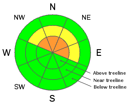
bottom line A CONSIDERABLE avalanche danger will be found on steep, wind drifted, upper elevation slopes and human triggered avalanches are likely. Terrain to avoid is steep, rocky, leeward slopes, especially where solid feeling slabs overlay weak sugary snow near the ground. In terrain with these characteristics avalanches have the possibility to break wide and deep, creating an unmanageably large and dangerous slide. A MODERATE avalanche danger exists on steep, wind drifted, mid elevation terrain and human triggered avalanches are possible. Low elevation terrain and slopes that were bare prior to Tuesday's big storm offer a LOW avalanche danger.
|
 |
special announcement We will be giving a free avalanche awareness presentation geared specifically for sledders at 5:00 this Friday at Ridgeline Motorsports located on 543 E Main St. in Vernal. Click here for more details. |
 |
current conditions Tuesday's storm parked over the western Uintas, dumping 14"- 20" of light density snow, with the north half of the range receiving the Lions share. Under clear skies, overnight lows crashed into brutally cold territory last night and still hover near -20 degrees at most locations. Northwest winds are blowing 10-15 mph along the high ridges producing wind chill factors to -35 degrees. It's not like the warm weather is gonna affect the snowpack anytime soon, so if you didn't remember to plug in the block heater overnight you'll still be ok with a crack o' noon start. This weeks storm dramatically improved the riding and turning conditions. Click here for current winds, temperatures, and snowfall throughout the range. Click here for trip reports and avalanche observations.
|
 |
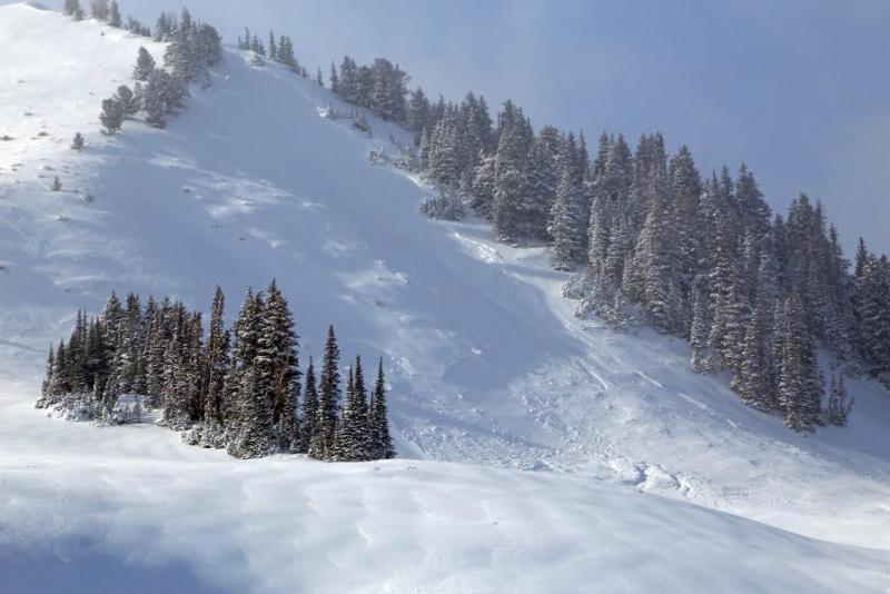
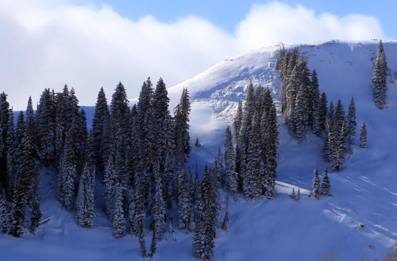
recent activity Thanks to Johnny Adolphson for the great pics!
This heavily wind loaded slope in Upper Weber Canyon avalanched naturally during the storm, breaking on weak October snow near the ground.
Even though this is a smaller avalanche, the fact that it broke to the ground shows how questionable our snowpack is at the moment. Our usual early season problem child- steep, rocky terrain remains suspect and should be avoided. |
| type | aspect/elevation | characteristics |
|---|

|
|
LIKELIHOOD
 LIKELY
UNLIKELY
SIZE
 LARGE
SMALL
TREND
 INCREASING DANGER
SAME
DECREASING DANGER
|
|
description
Our observations yesterday suggested there wasn't enough water weight or wind to produce a widespread natural avalanche cycle, but the perfect setup is in place for us to come along and knock the legs out from under the snowpack. Don't get tricked into thinking we're just dealing with a manageable storm snow avalanche problem. It's what's going on near the ground near the old October snow that's concerning. Once triggered, todays avalanches can break wider and deeper than you might expect and get quickly out of hand. Given the consequences of triggering a slide with the early season snow cover you'll want to continue avoiding any fat or rounded looking piece of snow, especially if it sounds hollow like a drum. Remember- even a small avalanche could take you for a nasty ride through rocks and stumps barely hidden under our shallow snowpack.
Three distinct layers in the snowpack with very clean shears. From top to bottom... storm snow, wind slab, weak snow near the ground. Once triggered, avalanches can break to the ground and you'd have a lot of snow coming down on top of you quickly ruining your season. Click here for a quick viddy explaining the snowpack setup.
|
 |
weather A very cold airmass remains over the region through the end of the week. A little sunshine will go a long way with today's highs struggling to break out of negative territory. Overnight lows reach to -20 again. Winds should be relatively calm just blowing 10-15 mph along the ridges. Increasing clouds late Friday signal another storm scheduled to impact the region early Saturday with an additional 6"-10" of storm snow possible by Sunday afternoon.
|
| general announcements Remember your information can save lives. If you see anything we should know about, please participate in the creation of our own community avalanche advisory by submitting snow and avalanche conditions. You can call me directly at 801-231-2170, email [email protected], or email by clicking HERE This is a great time of year to schedule a free avalanche awareness presentation for your group or club. You can contact me at 801-231-2170 or email [email protected] Donate to your favorite non-profit –The Utah Avalanche Center. The UAC depends on contributions from users like you to support our work. Benefit the Utah Avalanche Center when you buy or sell on ebay - set the Utah Avalanche Center as a favorite non-profit in your ebay account here and click on ebay gives when you buy or sell. You can choose to have your seller fees donated to the UAC, which doesn't cost you a penny. Utah Avalanche Center mobile app - Get your advisory on your iPhone along with great navigation and rescue tools. The information in this advisory is from the US Forest Service which is solely responsible for its content. This advisory describes general avalanche conditions and local variations always occur. I will update this advisory by 7:00 AM on Saturday Dec. 7, 2013 |


_0.jpg)