| During the month of April, Mark Miller will donate $75 to the charity of your choice (5 to chose from, including the Utah Avalanche Center!) Mark Miller Subaru has raised over $300k in the previous 6 Do Good Feel Good events. More Info here |  |
| During the month of April, Mark Miller will donate $75 to the charity of your choice (5 to chose from, including the Utah Avalanche Center!) Mark Miller Subaru has raised over $300k in the previous 6 Do Good Feel Good events. More Info here | |
| Advisory: Uintas Area Mountains | Issued by Craig Gordon for Tuesday - December 3, 2013 - 6:30am |
|---|

|
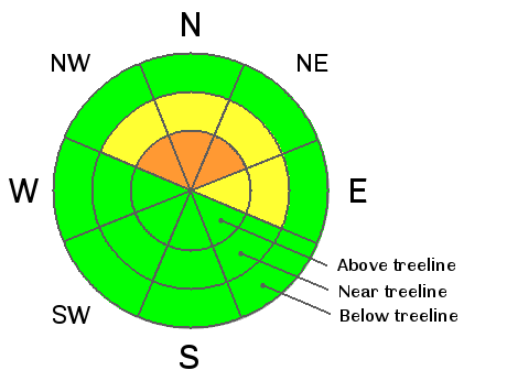
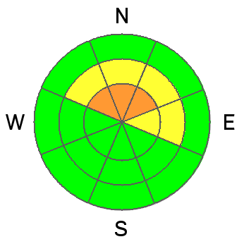
bottom line While mostly confined to the wind zone, a CONSIDERABLE avalanche danger will be found today in upper elevation leeward terrain. Human triggered avalanches are likely in steep, rocky, north facing terrain, especially where strong solid feeling slabs overlay weak sugary snow near the ground. Winds have gotten into mid elevation terrain, but fresh drifts are manageable and you'll find a MODERATE avalanche danger on steep wind drifted slopes and human triggered avalanches are possible.. South facing terrain which was bare prior to today's storm offers a LOW avalanche danger.
|
 |
current conditions Finally... a good shot of snow for the eastern front. Storm totals are pretty uniform with a solid 10" of snow stacking up at the upper elevations across the range. West and southwest winds cranked in the 50's and 60's most of yesterday, backing off into the 40's as the snow started to fall, and are currently blowing in the 30's along the upper ridges. Currently, temperatures are in the low to mid 20's. Riding and turning conditions have greatly improved overnight. Click here for current winds, temperatures, and snowfall throughout the range.
|
 |
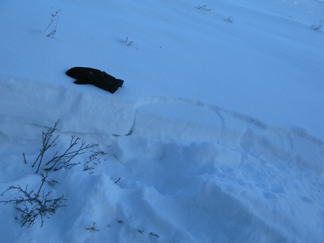
recent activity No new avalanche activity to report. |
| type | aspect/elevation | characteristics |
|---|

|
|
LIKELIHOOD
 LIKELY
UNLIKELY
SIZE
 LARGE
SMALL
TREND
 INCREASING DANGER
SAME
DECREASING DANGER
|
|
description
Fresh wind drifts are gonna be today's most obvious avalanche concern and they'll be found on the leeward side of upper elevation ridges, especially on slopes facing the north half of the compass. Rounded in appearance, today's drifts are easy to detect and avoid... this is a manageable avalanche problem. Not so manageable is the possibility of avalanches breaking to old snow near the ground. Remember- hard slabs formed by the big wind event two weeks ago will feel solid under our skis, board, or sled but they rest on very weak snow near the ground. One triggered, todays avalanches can break wider and deeper than you might expect and get quickly out of hand. Given the consequences of triggering a slide with the early season snow cover you'll want to continue avoiding any fat or rounded looking piece of snow, especially if it sounds hollow like a drum. Remember- even a small avalanche could take you for a nasty ride through rocks and stumps barely hidden under our shallow snowpack.
|
 |
weather Snow tapers off throughout the morning, though we could pick up an additional 2"-4". Winds shift to the northwest and blow in the 20's and 30's, and temperatures crash into the single digits. Brutally cold temperatures are the main message the next few days with light snow showers possible through the end of the week. Another shot of snow develops this weekend.
|
| general announcements Remember your information can save lives. If you see anything we should know about, please participate in the creation of our own community avalanche advisory by submitting snow and avalanche conditions. You can call me directly at 801-231-2170, email [email protected], or email by clicking HERE This is a great time of year to schedule a free avalanche awareness presentation for your group or club. You can contact me at 801-231-2170 or email [email protected] Donate to your favorite non-profit –The Friends of the Utah Avalanche Center. The UAC depends on contributions from users like you to support our work. The information in this advisory is from the US Forest Service which is solely responsible for its content. This advisory describes general avalanche conditions and local variations always occur. I will update this advisory by 7:00 AM on Wednesday Dec. 4, 2013 |


_0.jpg)