

Avalanche Advisory
| Advisory: Uintas Area Mountains | Issued by Craig Gordon for April 13, 2013 - 6:02am |
|---|


Above treeline
Near treeline
Below treeline
|
bottom line In the wind zone, at and above treeline, the avalanche danger is CONSIDERABLE and human triggered avalanches are likely on steep, wind drifted slopes. Once initiated, today's avalanches have the potential to break deep and wide, creating a large and dangerous slide. Steep, rocky, upper elevation terrain is most suspect. A MODERATE danger exists in mid elevation terrain and human triggered avalanches are possible on steep, wind drifted slopes Out of the wind and on low angle slopes the avalanche danger is generally LOW.
|

 |
special announcement My heart is heavy and it is with great sadness to report an avalanche accident involving a friend, colleague, and fellow avalanche professional. Craig Patterson, a highway avalanche forecaster, was tragically killed on Thursday in Big Cottonwood Canyon while investigating snowpack conditions. My thoughts, prayers, and energy go out to his friends and family. A report of the accident can be found here. |
 |
current conditions A quick moving storm is headed our way and clouds are already starting to spread into northern Utah. Currently, temperatures are in the upper 20's and low 30's and westerly winds started ramping up around 2:00 this morning, blowing in the 20's and 30's along the high peaks. Most of our midweek storm snow took on heat the past few days, but up high on direct north facing terrain you can still find soft settled powder.
Recent observations can be found here. Wondering why last winter was so crazy? Click here to watch the 2011-12 Utah Winter Review... an excellent recap of last years conditions.
|
 |
recent activity The past two storms have produced three very large avalanches, all breaking to the ground and failing on weak, sugary snow formed in January-
The North side of Lofty Lake Peak is the most recent addition. We think this natural slide occurred sometime Wednesday April 10th, as a result of the big storm and very strong winds.
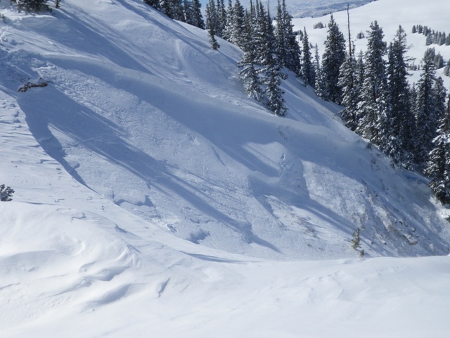
This avalanche near Cherry Hill on the North Slope was triggered on Wednesday April 10th from a weak, rocky section of terrain near the ridge.
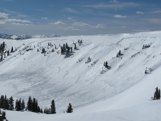
This very large natural slide in the Super Bowl occurred on the morning of April 3rd. The crown was over 1/2 mile wide and averages 30" in depth. Click here for a description explaining the slide and snowpack conditions leading to this very unusual event. Click here for recent observations from the region. |

Avalanche Problem 1over the next 24 hours
| type | aspect/elevation | characteristics |
|---|
 |
Above treeline
Near treeline
Below treeline
|
|
|
description
Nothing has changed on this front... there's a clear trend with our recent string of deeply triggered slides. Each time the snowpack gets rapidly loaded with snow, water, and wind we see avalanches breaking to the ground. The crazy thing is, it's April and we should have a strong solid snowpack, but this year it's different and the cold dryspell during January sealed the deal, helping to create and then preserve a very weak layer of sugary snow. Click here for a video describing the setup. Making conditions more sketchy is that you can ride plenty of slopes and be good to go, but if you find the right combination of strong snow overlying weak sugary snow chances are you're gonna collapse the slope and be staring down the barrel of a very dangerous slide. Our problem child hasn't gone away and steep, rocky slopes remain suspect. If you're travels take you onto a snowpack that feels punchy and you find yourself sinking into weak sugary snow, carefully evaluate the kind of terrain you're headed to and the kind of terrain you're connected to. Rather than complicating matters, you can avoid avalanches altogether and still have a blast carving on low angle slopes today.
|

Avalanche Problem 2over the next 24 hours
| type | aspect/elevation | characteristics |
|---|
 |


Above treeline
Near treeline
Below treeline
|
|
|
description
Increasing winds near the high peaks will produce sensitive wind drifts along the leeward side of upper elevation ridges. While this is generally a manageable avalanche problem, things could get out of hand quickly if the small wind drift you trigger breaks into weak sugary snow near the ground. If you're hopping from one drainage to another or changing aspect and elevation, tweak small test slopes and road cuts to see how they're reacting before getting after big terrain.
|

 |
weather A fast moving storm will clip northern Utah late this afternoon, producing a couple inches of snow overnight. In the meantime, we can expect increasing clouds and southwest winds gusting to 50 mph by late in the day. High temperatures climb into the low 40's before diving into the teens overnight. A break in the action is slated for Sunday and then cold, unsettled weather lines up for a good portion of next week. |
| general annoucements Remember your information can save lives. If you see anything we should know about, please participate in the creation of our own community avalanche advisory by submitting snow and avalanche conditions. You can call me directly at 801-231-2170, email [email protected], or email by clicking HERE This is a great time of year to schedule a free avalanche awareness presentation for your group or club. You can contact me at 801-231-2170 or email [email protected] Donate to your favorite non-profit –The Friends of the Utah Avalanche Center. The UAC depends on contributions from users like you to support our work. The information in this advisory is from the US Forest Service which is solely responsible for its content. This advisory describes general avalanche conditions and local variations always occur. The information in this advisory expires 24 hours after the date and time posted, but will be updated by 7:00 AM Sunday April 14th. |