

Avalanche Advisory
| Advisory: Uintas Area Mountains | Issued by Craig Gordon for April 9, 2013 - 6:24am |
|---|


Above treeline
Near treeline
Below treeline
|
bottom line In the wind zone, at and above treeline, the avalanche danger is CONSIDERABLE and human triggered avalanches are likely on steep, wind drifted slopes. Once initiated, today's avalanches have the potential to break deep and wide, creating a large and dangerous slide. The east side of the range received a tremendous amount of snow and water and the avalanche danger is more pronounced the further east you travel. A MODERATE danger exists on steep wind drifted slopes at mid elevation and human triggered avalanches within the new storm snow are possible. Out of the wind and on low angle slopes the avalanche danger is generally LOW.
|

 |
special announcement This Sunday April 14th will be the last of our regularly scheduled advisories
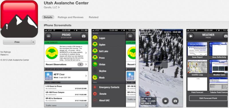
iPhone & iPad users: With help from Backcountry.com & Garafa, LLC, we now have a free mobile app that combines the best of the UAC advisories, observations, and weather summaries with National Weather Service products & UDOT road updates. This puts the tools you need for planning your day and your run in one handy mobile package. Check it out, tell your friends, and let us know what you think. http://utahavalanchecenter.org/apps
|
 |
current conditions Storm totals are a bit unevenly distributed, but the eastern and northern portions of the range received at least 16" of new snow with 1.5 H2O in the past 24 hrs. The south half of the range didn't fare as well.... storm totals are in the 4"-8" range. Southeast winds gusted in the 30's and 40's yesterday before switching to the north around 5:00 and then rapidly decreasing. Currently, winds are light and variable, blowing 5-10 mph, and temperatures are in the single digits.
Recent observations can be found here. Wondering why last winter was so crazy? Click here to watch the 2011-12 Utah Winter Review... an excellent recap of last years conditions.
|
 |
recent activity
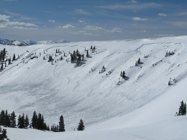
The region received a one-two punch last week... heavy, dense snow and a rapid warm up conspired against our weak snowpack. This very large natural slide in the Super Bowl occurred around 11:00 on the morning of the 3rd. The crown was over 1/2 mile wide, averages 30" in depth, and broke to weak old snow formed during the January dryspell. Click here for a description explaining the slide and snowpack conditions leading to this very unusual event. Click here for recent observations from the region. |
Avalanche Problem 1over the next 24 hours
| type | aspect/elevation | characteristics |
|---|
 |
Above treeline
Near treeline
Below treeline
|
|
|
description
It's remarkable to me that we're still taking about avalanches breaking to the ground and here it is the first week of April when we're usually enjoying manageable avalanches conditions on a solid, go anywhere base. This year it's different and the cold dryspell during January sealed the deal, helping to create and then preserve a very weak base. Up until the last series of storms we were good to go because there was no slab. Now however, the storm snow has settled and consolidated into a dense layer of snow. Unfortunately it rests on a persistent weakness (a very weak layer of depth hoar) and we've got all the ingredients for an unmanageable avalanche. Making conditions more sketchy is that you can ride plenty of slopes and be good to go, but if you find the right combination of strong snow overlying weak sugary snow chances are you're gonna collapse the slope and be staring down the barrel of a very dangerous slide. Our problem child hasn't gone away and steep, rocky slopes remain suspect. If you're travels take you onto a snowpack that feels punchy and you find yourself sinking into weak sugary snow, carefully evaluate the kind of terrain you're headed to and the kind of terrain you're connected to. Rather than complicating matters, you can avoid avalanches altogether and still have a blast carving on low angle slopes today.
|

Avalanche Problem 2over the next 24 hours
| type | aspect/elevation | characteristics |
|---|
 |


Above treeline
Near treeline
Below treeline
|
|
|
description
Winds have been all over the place the last 24 hours and fresh wind drifts along the leeward side of upper elevation ridges and around terrain features like chutes and gullies are today's most obvious avalanche dragon. While these slabs may seem mostly manageable, once triggered it's gonna be a different story and they'll be packing a punch. It's a good day to tweak small test slopes and road cuts to see how they're reacting before getting after big terrain.
|
 |
weather Snow showers will continue throughout the day with accumulations in the 1"3" range. North and northeast winds are expected to increase into the 30's as the day wares on. High temperatures climb into the mid 20's before diving into the single digits overnight. Partly sunny skies with temperatures rising into the low 40's are on tap for Wednesday. A weak storm slides into the region Thursday with high pressure building for the end of the week. |
| general annoucements Remember your information can save lives. If you see anything we should know about, please participate in the creation of our own community avalanche advisory by submitting snow and avalanche conditions. You can call me directly at 801-231-2170, email [email protected], or email by clicking HERE This is a great time of year to schedule a free avalanche awareness presentation for your group or club. You can contact me at 801-231-2170 or email [email protected] Donate to your favorite non-profit –The Friends of the Utah Avalanche Center. The UAC depends on contributions from users like you to support our work. The information in this advisory is from the US Forest Service which is solely responsible for its content. This advisory describes general avalanche conditions and local variations always occur. The information in this advisory expires 24 hours after the date and time posted, but will be updated by 7:00 AM Wednesday April 10th. |