

Avalanche Advisory
| Advisory: Uintas Area Mountains | Issued by Craig Gordon for April 7, 2013 - 6:00am |
|---|


Above treeline
Near treeline
Below treeline
|
bottom line While not widespread, pockets of CONSIDERABLE danger will be found at and above treeline. Human triggered avalanches are likely, particularly on steep, rocky slopes, facing the north half of the compass where strong feeling snow overlies weak sugary snow. The danger of wet avalanches is generally LOW this morning, but will rapidly rise to MODERATE, especially if the sun pokes out for any length of time. Human triggered wet slides and sluffs will be possible and you'll want to get off of and out from under steep slopes during the heat of the day
|

 |
special announcement A large Pacific storm is slated to impact the region the next few days and the avalanche danger will be on the rise. I will update this advisory throughout the week accordingly. Next Sunday April 14th will be the last of our regularly scheduled advisories
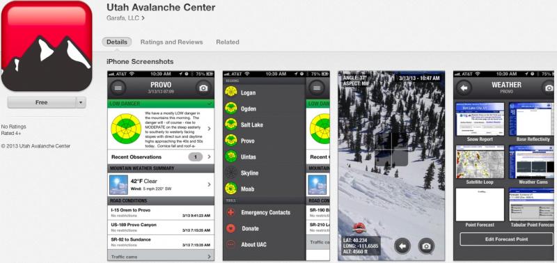
iPhone & iPad users: With help from Backcountry.com & Garafa, LLC, we now have a free mobile app that combines the best of the UAC advisories, observations, and weather summaries with National Weather Service products & UDOT road updates. This puts the tools you need for planning your day and your run in one handy mobile package. Check it out, tell your friends, and let us know what you think. http://utahavalanchecenter.org/apps
|
 |
current conditions A moist westerly flow continues home-steading over the region allowing another 2" of dense snow to fall yesterday. Currently, skies are mostly cloudy, temperatures in the mid to upper 20's, and west-northwest winds are blowing 10-20 mph along the ridges. Don't get too discouraged at the lack of low elevation trailhead snow... riding and turning conditions remain quite good up high where you'll find dense, spongy snow on a mostly supportable base.
From hero to zero. The lower elevations took a hard hit this week as warm temperatures and light rain have taken their toll.
Up high it's a different story.
Recent observations can be found here. Wondering why last winter was so crazy? Click here to watch the 2011-12 Utah Winter Review... an excellent recap of last years conditions.
|
 |
recent activity
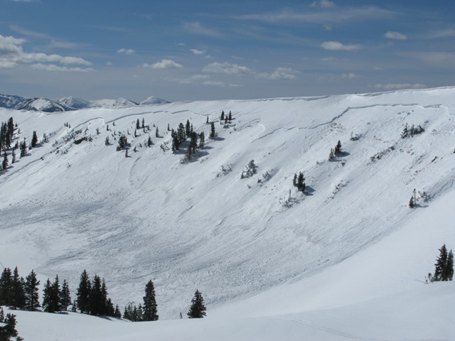
The region received a one-two punch this week... heavy, dense snow and a rapid warm up conspired against our weak snowpack. This very large natural slide in the Super Bowl occurred around 11:00 on the morning of the 3rd. The crown was over 1/2 mile wide, averages 30" in depth, and broke to weak old snow formed during the January dryspell. Click here for a description explaining the slide and snowpack conditions leading to this very unusual event. Click here for recent observations from the region. |
Avalanche Problem 1over the next 24 hours
| type | aspect/elevation | characteristics |
|---|
 |
Above treeline
Near treeline
Below treeline
|
|
|
description
It's remarkable to me that we're still taking about avalanches breaking to the ground and here it is the first week of April when we're usually enjoying manageable avalanches conditions on a solid, go anywhere base. This year it's different and the cold dryspell during January sealed the deal, helping to create and then preserve a very weak base. Up until the last series of storms we were good to go because there was no slab. Now however, the storm snow has settled and consolidated into a dense layer of snow. Unfortunately it rests on a persistent weakness (a very weak layer of depth hoar) and we've got all the ingredients for an unmanageable avalanche. Making conditions more sketchy is that you can ride plenty of slopes and be good to go, but if you find the right combination of strong snow overlying weak sugary snow chances are you're gonna collapse the slope and be staring down the barrel of a very dangerous slide. Our problem child hasn't gone away and steep, rocky slopes remain suspect. If you're travels take you onto a snowpack that feels punchy and you find yourself sinking into weak sugary snow, carefully evaluate the kind of terrain you're headed to and the kind of terrain you're connected to. Rather than complicating matters, you can avoid avalanches altogether and still have a blast carving on low angle slopes today.
|

Avalanche Problem 2over the next 24 hours
| type | aspect/elevation | characteristics |
|---|
 |


Above treeline
Near treeline
Below treeline
|
|
|
description
Most low elevation south facing slopes are bare and brushy, but at mid and upper elevations I found the moist snow pretty well behaved yesterday. Roller balls along with a few shallow damp surface sluffs were about the only wet activity I observed. I bet it's gonna be the same story today. Of course, the wild card is the third rock from the earth. If the sun comes out for any period of time today the activity will spike accordingly. Generally manageable in size and depth, you'll still want to avoid terrain traps like gullies and road cuts, where even a small slide can pile up bone snapping debris very deeply.
|
Avalanche Problem 3over the next 24 hours
| type | aspect/elevation | characteristics |
|---|
 |
Above treeline
Near treeline
Below treeline
|
|
|
description
Cornices continue to have the possibility to break back further than you might expect.
|

 |
weather A couple ripples in the storm track should slide across the region today, bringing scattered snow showers with a few inches of snow possible. Temperatures warm into the low and mid 40's before dipping into the mid 20's overnight. The big news is the increase in wind late this afternoon. Westerly winds should be blowing steadily in the 20's and 30's with gusts in the mid 40's by late in the day. A cold and slow moving storm settles in over the region on Monday and should linger through Tuesday night. Right now this looks like a good snow and water producer for the region. I'll have a handle on timing and amounts for Monday's update. |
| general annoucements Remember your information can save lives. If you see anything we should know about, please participate in the creation of our own community avalanche advisory by submitting snow and avalanche conditions. You can call me directly at 801-231-2170, email [email protected], or email by clicking HERE This is a great time of year to schedule a free avalanche awareness presentation for your group or club. You can contact me at 801-231-2170 or email [email protected] Donate to your favorite non-profit –The Friends of the Utah Avalanche Center. The UAC depends on contributions from users like you to support our work. The information in this advisory is from the US Forest Service which is solely responsible for its content. This advisory describes general avalanche conditions and local variations always occur. The information in this advisory expires 24 hours after the date and time posted, but will be updated by 7:00 AM Monday April 8th. |