

Avalanche Advisory
| Advisory: Uintas Area Mountains | Issued by Craig Gordon for March 17, 2013 - 6:08am |
|---|


Above treeline
Near treeline
Below treeline
|
bottom line The avalanche danger will rise to MODERATE and human triggered avalanches will become possible on steep, sunny slopes, especially during the heat of the day. In addition, human triggered avalanches are possible in steep, upper elevation wind drifted terrain where a MODERATE avalanche danger exists. Out of the wind and on low angle slopes with no steep terrain above or adjacent to where you're riding, you'll find a LOW avalanche danger.
|

 |
current conditions A cold front is sweeping through the region this morning, bringing with it temperatures in the low to mid 20's, gusty winds, and an inch or two of snow overnight. West and southwest winds ramped up around midnight and are currently blowing 30-60 mph along the high ridges. Snow surface conditions are gonna be a mixed bag and it might be best to get a later start to the day as the storm exits and skies clear. Recent observations can be found here. Our entire Uinta weather station network is up and running. A link to real-time wind, snow, and temperature data can be found here. This monumental achievement couldn't have happened without the joint efforts from the National Weather Service, The Heber-Kamas and Evanston Ranger Districts, Park City Powder Cats, and all the great work by Ted, Trent, Cody, and Al. Thanks to everyone... this is awesome! Wondering why last winter was so crazy? Click here to watch the 2011-12 Utah Winter Review... an excellent recap of last years conditions.
|
 |
recent activity
Dan Gardiner sent these images in from the Duchesne Ridge. While not widespread and pockety in nature, you can clearly see avalanches breaking to the ground in steep, rocky terrain. Click here for recent observations from the region. |
Avalanche Problem 1over the next 24 hours
| type | aspect/elevation | characteristics |
|---|
 |
Above treeline
Near treeline
Below treeline
|
|
|
description
Cold temperatures are the great equalizer when it comes to wet avalanche activity and last nights shot of cooler air probably put the lid on the vast majority of the wet issues we've been experiencing the past few days. While most terrain received a good solid refreeze, there may still be some outliers where you could trigger a wet, manky slide that breaks into weak saturated snow near the ground. You know the routine... steep, rocky slopes that have had a weak, shallow snowpack all season should be considered suspect. Also, if you find yourself sinking into weak sugary snow or experience collapses of the snowpack, you've overstayed your welcome. The way to combat getting tangled up in one of these heavy, cement mixer-like slides is to avoid steep sunny slopes during the heat of the day and steer clear of terrain traps like road cuts and gullies.
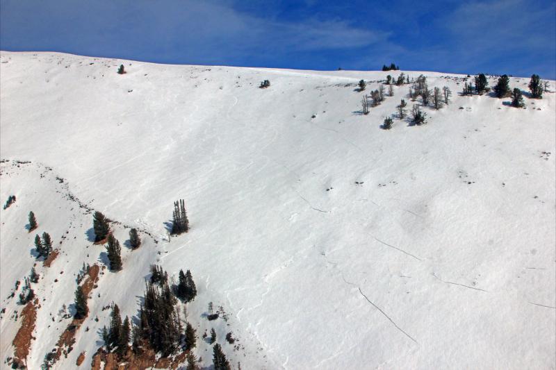
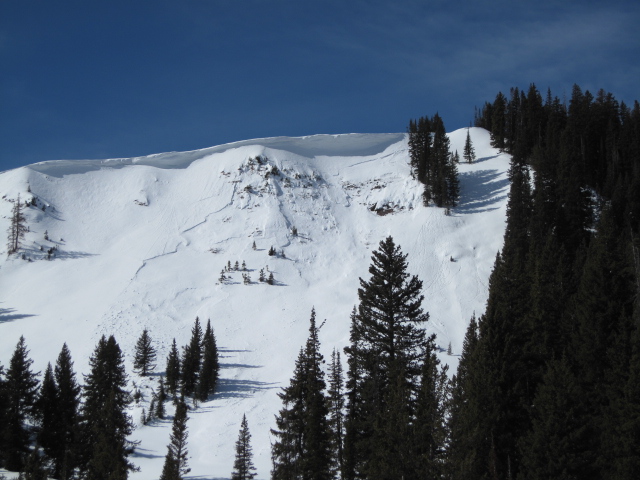
This upper elevation Southeast facing slope in Upper Weber Canyon collapsed and spider-webbed on Friday, but wasn't steep enough to slide. Many thanks to Johnny Adolphson for these killer pics!
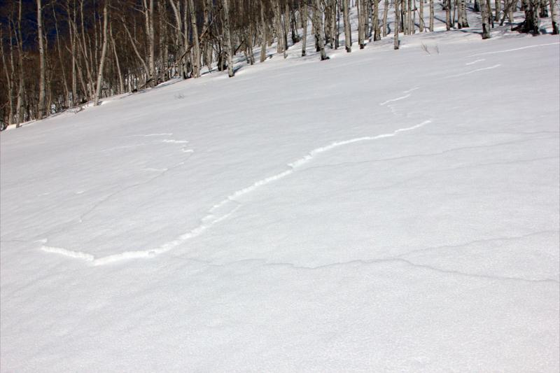
This high elevation north facing slope illustrates how a small slide can quickly break to weak snow in steep rocky terrain facing the north half of the compass. |

Avalanche Problem 2over the next 24 hours
| type | aspect/elevation | characteristics |
|---|
 |


Above treeline
Near treeline
Below treeline
|
|
|
description
The new snow and strong wind will form a few fresh drifts along the leeward side of upper elevation ridges. Manageable in size and depth, today's shallow slabs will predictably break at or below you skis, board, or sled.
|

 |
weather Another inch or two of snow is possible and then we should see clearing skies and a beautiful afternoon. Winds are gonna be a nuisance and they'll be gusting into the 50's and 60's along the high ridges. Temperatures don't vary much from where we're at this morning and should crash into the low teens overnight. Sunny skies and slightly warmer for Monday and Tuesday and then it looks like a good shot of snow is shaping up for late Wednesday into Thursday. High pressure returns for Friday.
|
| general annoucements Remember your information can save lives. If you see anything we should know about, please participate in the creation of our own community avalanche advisory by submitting snow and avalanche conditions. You can call me directly at 801-231-2170, email [email protected], or email by clicking HERE This is a great time of year to schedule a free avalanche awareness presentation for your group or club. You can contact me at 801-231-2170 or email [email protected] Donate to your favorite non-profit –The Friends of the Utah Avalanche Center. The UAC depends on contributions from users like you to support our work. The information in this advisory is from the US Forest Service which is solely responsible for its content. This advisory describes general avalanche conditions and local variations always occur. The information in this advisory expires 24 hours after the date and time posted, but will be updated by 7:00 AM Wednesday March 20th. |