

Avalanche Advisory
| Advisory: Uintas Area Mountains | Issued by Craig Gordon for March 16, 2013 - 6:29am |
|---|


Above treeline
Near treeline
Below treeline
|
bottom line The danger for wet avalanches will rise to CONSIDERABLE and human triggered slides are likely at all elevations during the heat of the day. If you feel like an ant under a magnifying glass, you know the snowpack is going through a change as well and it's time to get off of and out from under steep slopes. In addition, avoid terrain traps like gullies, where huge piles of bone snapping debris can stack up very deeply.
|

 |
current conditions A weak cold front slid through the region while we were all sleeping, ushering in a thick band of clouds and helping to drop temperatures about 8 degrees from where stood at this time yesterday morning... though it's still quite mild. Currently, temperatures are in the upper 20's and low 30's and westerly winds are blowing 25-35 mph along the high ridges. A thin crust formed overnight, but it's supportability will be short-lived once the sun starts baking the snow surface. In general, riding and turning conditions took a hard hit yesterday and it might be best to get chores out of the way and wait for tonight's storm to materialize. Recent observations can be found here. Our entire Uinta weather station network is up and running. A link to real-time wind, snow, and temperature data can be found here. This monumental achievement couldn't have happened without the joint efforts from the National Weather Service, The Heber-Kamas and Evanston Ranger Districts, Park City Powder Cats, and all the great work by Ted, Trent, Cody, and Al. Thanks to everyone... this is awesome! Wondering why last winter was so crazy? Click here to watch the 2011-12 Utah Winter Review... an excellent recap of last years conditions.
|
 |
recent activity
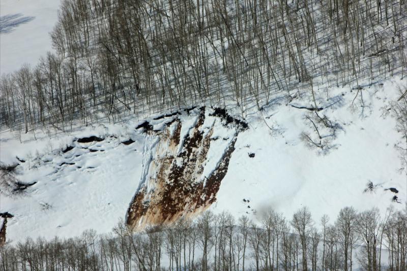
With a shallow Thursday night refreeze, wet avalanches gouging to the ground, like this one, were common yesterday on steep road cuts.
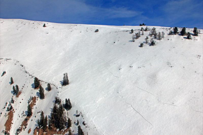
In the foreground a supportable feeling piece of snow collapsed and cracked, but didn't avalanche because the slope angle was only 30 degrees. In the background across the canyon, you can see recent avalanches that broke to the ground in steep rocky terrain. Click here for recent observations from the region. |

Avalanche Problem 1over the next 24 hours
| type | aspect/elevation | characteristics |
|---|
 |
Above treeline
Near treeline
Below treeline
|
|
|
description
Last nights minor snowpack refreeze probably won't help to lock up the deeper issues our snowpack is experiencing and I expect another round of wet avalanche activity, especially as the day heats up. There's two specific types of wet issues we're dealing with and they'll react slightly different depending on aspect and elevation. First... on the south half of the compass you'll find crusts early in the day, but it's what's underneath this thin supportable veneer that's alarming. A virtual sandbox of very weak sugary facets is all the structure that exists. Supportable, melt-freeze crust or "corn-slab" avalanches are a bit bizarro and quite counter-intuitive. However, it goes back to snowpack 101 basics- strong snow on weak snow... bad combination. When the snow surface feels solid and bomber it can react just like a hard slab on weak snow. All we need to do is find a weak spot in the snowpack, collapse the slope, and it shatters just like a pane of glass. On the shady side of the compass, the snow surface will feel more powdery, but the warmth has taken it's toll, especially in terrain that has remained shallow all season. Once triggered, avalanches can gouge into weaker layers of snow, creating a much bigger slide than you might've expected. In either case the way to combat getting tangled up in one of these heavy, cement mixer-like slides is to avoid steep sunny slopes during the heat of the day and steer clear of terrain traps like road cuts and gullies.
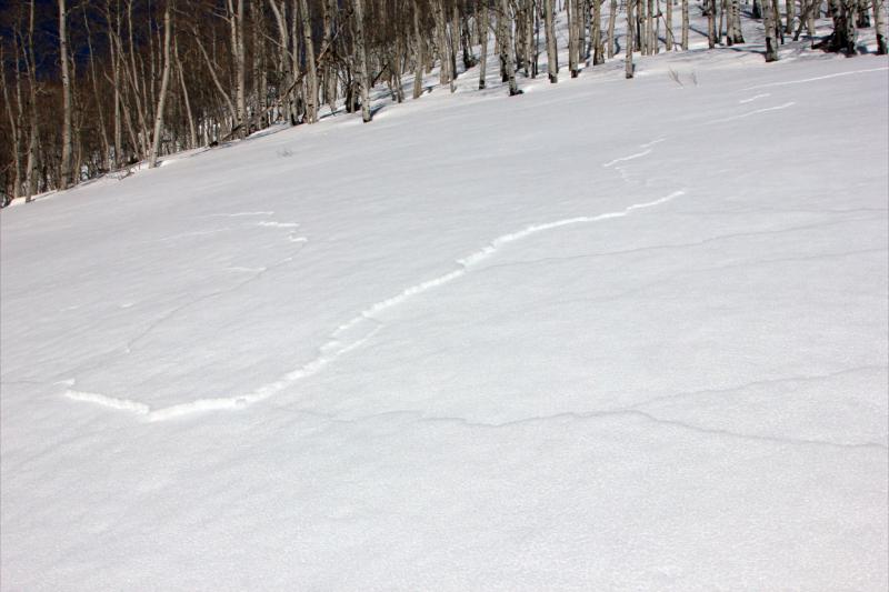
This upper elevation Southeast facing slope in Upper Weber Canyon collapsed and spider-webbed, but wasn't steep enough to slide. Many thanks to Johnny Adolphson for these killer pics!
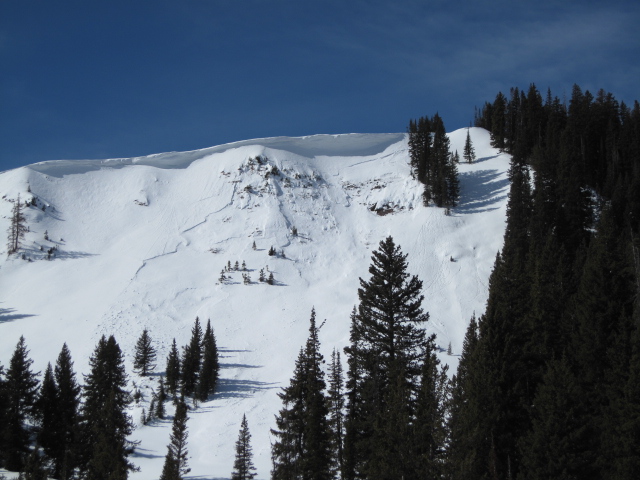
This high elevation north facing slope illustrates how a small slide can quickly break to weak snow in steep rocky terrain facing the north half of the compass. |

Avalanche Problem 2over the next 24 hours
| type | aspect/elevation | characteristics |
|---|
 |

Above treeline
Near treeline
Below treeline
|
|
|
description
Cornices are large and have grown quite tender, breaking back further than you might expect. Once released, a large piece of cornice could easily initate an avalanche that quickly gets out of hand. Best to avoid these unpredictable pieces of snow.
|
 |
weather Clouds should thin out as the day progresses and temperatures climb into the upper 30's. Westerly winds gust into the 30's and 40's along the high ridges, increasing late in the day, helping to usher in a storm that should deliver 4" of snow by midday Sunday. A cold northwest flow sets up for early in the week, followed by a pair of storms slated to reach the region Thursday and Friday. We should see a decent shot of snow before sunny skies and high pressure builds for next weekend.
|
| general annoucements Remember your information can save lives. If you see anything we should know about, please participate in the creation of our own community avalanche advisory by submitting snow and avalanche conditions. You can call me directly at 801-231-2170, email [email protected], or email by clicking HERE This is a great time of year to schedule a free avalanche awareness presentation for your group or club. You can contact me at 801-231-2170 or email [email protected] Donate to your favorite non-profit –The Friends of the Utah Avalanche Center. The UAC depends on contributions from users like you to support our work. The information in this advisory is from the US Forest Service which is solely responsible for its content. This advisory describes general avalanche conditions and local variations always occur. The information in this advisory expires 24 hours after the date and time posted, but will be updated by 7:00 AM Sunday March 17th. |