

Avalanche Advisory
| Advisory: Uintas Area Mountains | Issued by Craig Gordon for March 7, 2013 - 6:41am |
|---|


Above treeline
Near treeline
Below treeline
|
bottom line Terrain to avoid- In the wind zone at and above treeline, a CONSIDERABLE avalanche danger exists and human triggered avalanches are likely on steep, leeward, northwest through southeast facing slopes. Once triggered, avalanches can break into deeply buried weak layers of snow, creating a large and dangerous avalanche. A MODERATE avalanche danger is found at mid elevations and human triggered avalanches are possible on steep wind drifted slopes. Go to terrain- If you're looking for LOW avalanche danger, head to wind sheltered terrain or carve turns on flat meadows with no steep slopes above or adjacent to where you're riding.
|

 |
current conditions Clouds drifted into the region late yesterday and brought with them a very angry inch of snow. Southerly winds ramped up early in the morning and blew 50-70 mph for most of the day. Winds died down around midnight, but are still blowing 25-40 mph along the high peaks. Temperatures remained mild overnight and are currently in the low to mid 20's. While riding and turning conditions are a bit hit or miss up high, soft snow is found on wind sheltered, shady slopes. Recent observations can be found here. Our entire Uinta weather station network is up and running. A link to real-time wind, snow, and temperature data can be found here. This monumental achievement couldn't have happened without the joint efforts from the National Weather Service, The Heber-Kamas and Evanston Ranger Districts, Park City Powder Cats, and all the great work by Ted, Trent, Cody, and Al. Thanks to everyone... this is awesome! Wondering why last winter was so crazy? Click here to watch the 2011-12 Utah Winter Review... an excellent recap of last years conditions.
|
 |
recent activity
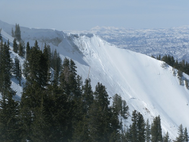
Southwest winds picked up Monday leading to this natural cornice fall on a steep northeast facing slope in Chalk Creek which subsequently triggered a slab lower on the slope. Click here for recent observations from the region. |
Avalanche Problem 1over the next 24 hours
| type | aspect/elevation | characteristics |
|---|
 |


Above treeline
Near treeline
Below treeline
|
|
|
description
Yesterday's winds were stronger than anticipated and they rapidly formed sensitive slabs on steep, upper elevation, leeward slopes. Winds are forecast to remain active throughout the day and I expect slabs will continue to grow and will break deeper and wider than you might expect. Once triggered, today's slides could break into weak layers of snow buried deeper in the snowpack, resulting in a large and unmanageable slide. Easy to detect and easier to avoid, fat rounded pillows of snow are a good clue to wind loaded slopes. You'll find the vast majority of these in steep, shady terrain at and above treeline.
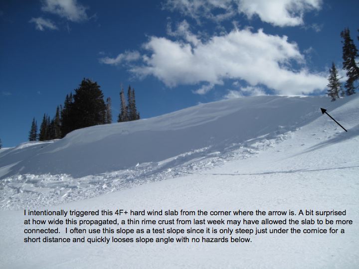
Yesterday's winds were busy at work, rapidly forming sensitive drifts on steep, shady, upper elevation slopes.
Check out the rest of Ted's great trip report from Whitney Basin yesterday. This guy is so on top of it! What a great example of the kind of slope you can tweak and see how it's reacting, rather than charging blindly into big terrain.
|


Avalanche Problem 2over the next 24 hours
| type | aspect/elevation | characteristics |
|---|
 |
Above treeline
Near treeline
Below treeline
|
|
|
description
It's amazing. Here it is March and we're still talking about a shallow snowpack and avalanches breaking to weak faceted snow. What really blows me away is that some of our weakest snow is found on sunny slopes. In many places it's a sandbox, but right now lacks a key ingredient... a well connected slab. On the shady half of the compass the structure is a bit different and there's more body or strength to the snow. The downside of north facing terrain, however, is that there is a slab overlying weak snow. The most likely terrain to trigger a deep, unmanageable slide is gonna be in the usual suspects- steep, rocky, upper elevation slopes facing the north half of the compass. The best way to combat triggering a deep dangerous slide is with terrain selection. Tone it down a notch or two and you can still have a blast carving turns on low angle terrain.
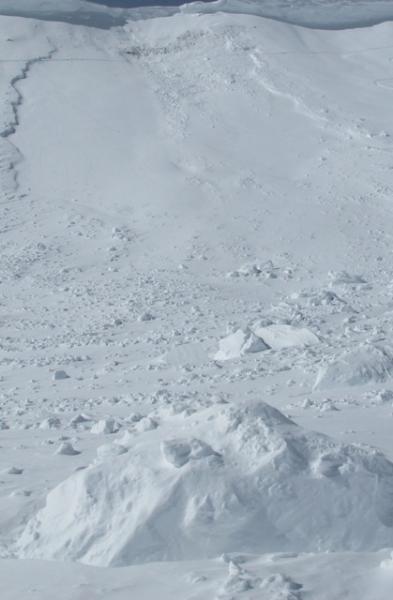
This south facing slope took a big hit with a huge piece of cornice slamming down on it, triggering a slide that broke to weak January snow.
|
Avalanche Problem 3over the next 24 hours
| type | aspect/elevation | characteristics |
|---|
 |
Above treeline
Near treeline
Below treeline
|
|
|
description
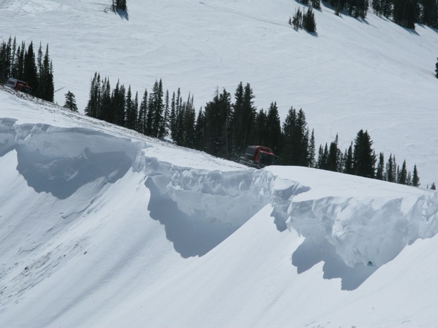
Do these lips make my slabs look fat? Cornices have grown huge and may break back further than you might expect. You'll want to steer clear of these unpredictable pieces of snow. |
 |
weather Under mostly cloudy skies, a few scattered snow showers are possible, but southerly winds top today's headline news. They should continue to blow today and tonight, 20-30 mph with gusts in the 50's along the high ridges. Temperatures climb into the low 30's before dipping into the upper teens overnight. Snow develops overnight with a few inches possible by Friday afternoon. The bulk of the storm slides into central and southern Utah over the weekend, giving us a continued chance of light snow.
|
| general annoucements Remember your information can save lives. If you see anything we should know about, please participate in the creation of our own community avalanche advisory by submitting snow and avalanche conditions. You can call me directly at 801-231-2170, email [email protected], or email by clicking HERE This is a great time of year to schedule a free avalanche awareness presentation for your group or club. You can contact me at 801-231-2170 or email [email protected] Donate to your favorite non-profit –The Friends of the Utah Avalanche Center. The UAC depends on contributions from users like you to support our work. The information in this advisory is from the US Forest Service which is solely responsible for its content. This advisory describes general avalanche conditions and local variations always occur. The information in this advisory expires 24 hours after the date and time posted, but will be updated by 7:00 AM Saturday March 9th. |