

Avalanche Advisory
| Advisory: Uintas Area Mountains | Issued by Craig Gordon for January 27, 2013 - 5:48am |
|---|


Above treeline
Near treeline
Below treeline
|
bottom line At and above treeline pockets of MODERATE avalanche danger exist and human triggered avalanches are possible in steep terrain harboring both old and recent deposits of wind drifted snow. LOW avalanche danger is found in most wind sheltered terrain.
|

 |
special announcement
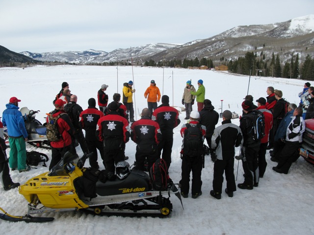
Huge thanks to everyone who attended this weekends Snowmobile Avy Essentials class. The workshop was a huge success with two dozen high end riders participating. It was great to connect with old friends and make some new ones as well. I couldn't have pulled this off without the support and generosity of Tommy George and Tri-City Performance, Park City Powder Cats, and the expertise offered by an amazing cast of instructors. Making it all happen on the snow side of things- Trent Meisenheimer, Andy VanHouten, Seth Roller, Jason Boyer, Tyler St Jeor, and Cody Hughes. The riding component was headed up by the top notch skills offered up by Dan Gardiner, Geoff Dyer, Ryan Nelson, and Nick Reedy. You guys are amazing and it was very generous of you to donate your time to provide such a killer class! |
 |
current conditions Clouds are streaming into the region ahead of a Pacific storm slated to impact the area later today. Temperatures remained warm overnight and are currently in the mid to upper 20's. South and southwest winds were mellow all night and just started increasing around 5:00 this morning with averages in the teens and gusts in the low 30's. Snow surface conditions are damp and funky down low, but with a little elevation gain you can still find soft, creamy powder on wind sheltered, shady terrain. Other observations can be found here. Wondering why last winter was so crazy? Click here to watch the 2011-12 Utah Winter Review... an excellent recap of last years conditions. |
 |
recent activity
While not widespread, we noticed a few shallow natural soft slabs breaking about a foot deep in steep leeward terrain Friday.
Trent points to a weak layer of facets developed during the early January dry spell. Nearly all of our recent shallow avalanche activity revolves around this layer which is now buried and preserved. This is a layer to keep track of, especially with additional snow, water, and wind expected in the next few days.
We investigated last Friday's very tragic avalanche accident. A report can be found here.
|


Avalanche Problem 1over the next 24 hours
| type | aspect/elevation | characteristics |
|---|
 |
Above treeline
Near treeline
Below treeline
|
|
|
description
Winds will be increasing throughout the day, forming fresh wind drifts along the leeward side of upper elevation ridges. While you'll find the majority of fresh slabs on steep slopes facing the north half of the compass, as winds start to increase, I wouldn't be too surprised to see a few drifts forming lower on the slope and in terrain features like chutes and gullies. In either case, these will become more widespread and more sensitive as the day wares on. Fat looking, rounded pillows of snow, especially those that sound hollow like a drum should still be considered suspect and avoided.
.
|

Avalanche Problem 2over the next 24 hours
| type | aspect/elevation | characteristics |
|---|
 |
Above treeline
Near treeline
Below treeline
|
|
|
description
Cornices have grown in the past few days and you definitely don't want to tangle with these unpredictable dragons which may break back further than you might expect, taking you for a fast, violent, body beating ride through trees or over a cliff band.
|

Avalanche Problem 3over the next 24 hours
| type | aspect/elevation | characteristics |
|---|
 |
Above treeline
Near treeline
Below treeline
|
|
|
description
The next round of weather may be enough to reactivate weak snow near the ground which has been dormant the past few weeks. While it's an outlier, it's worth mentioning steep, rocky terrain where strong feeling snow overlies weak sugary snow near the ground. If your travels take you into steep, upper elevation, complex terrain, facing the facing the north half of the compass, carefully assess the snowpack and consider the consequences of triggering a slide.
|
 |
weather A moist Pacific storm system impacts the region today and Monday. Under mostly cloudy skies we'll see increasing south and southwest winds gusting into the 50's and 60's by afternoon. Temperatures climb into the low 30's before crashing into the teens overnight once the cold front arrives. Winds shift to the west and northwest late in the day and a good shot of snow accompanies the front. Looks like 8"-`10" of new snow is a pretty good bet. Another wave moves into the region late Monday into Tuesday, ushering in an additional round of snow before high pressure builds more mid week. |
| general annoucements Remember your information can save lives. If you see anything we should know about, please participate in the creation of our own community avalanche advisory by submitting snow and avalanche conditions. You can call me directly at 801-231-2170, email [email protected], or email by clicking HERE This is a great time of year to schedule a free avalanche awareness presentation for your group or club. You can contact me at 801-231-2170 or email [email protected] Donate to your favorite non-profit –The Friends of the Utah Avalanche Center. The UAC depends on contributions from users like you to support our work. The information in this advisory is from the US Forest Service which is solely responsible for its content. This advisory describes general avalanche conditions and local variations always occur. The information in this advisory expires 24 hours after the date and time posted, but will be updated by 7:00 AM Wednesday January 30th. |