

Avalanche Advisory
| Advisory: Uintas Area Mountains | Issued by Craig Gordon for January 6, 2013 - 5:36am |
|---|


Above treeline
Near treeline
Below treeline
|
bottom line Terrain to avoid- Steep, rocky, upper elevation slopes where human triggered avalanches breaking near the ground are still possible. In general though, you'll find a MODERATE avalanche danger and human triggered avalanches are possible on steep, wind drifted slopes. LOW avalanche danger is found in wind sheltered terrain.
|

 |
special announcement Please join us on Thursday evening, 1/24 and Saturday, 1/26 for a day of learning avalanche and advanced riding skills with Craig & Trent from the Utah Avalanche Center and Dan Gardiner and the Boondockers crew. Details and sign up here |
 |
current conditions A weak storm diving to the south of the region is pumping clouds into the area, but there's really no moisture to speak of. Southeasterly winds are blowing 15-25 mph along the ridges and temperatures are in the mid to upper 20's. While big open bowls and above treeline terrain got worked by strong winds early in the week, outstanding settled powder is found in wind protected terrain at mid and lower elevations.
Recent observations can be found here. Wondering why last winter was so crazy? Click here to watch the 2011-12 Utah Winter Review... an excellent recap of last years conditions. |

 |
recent activity
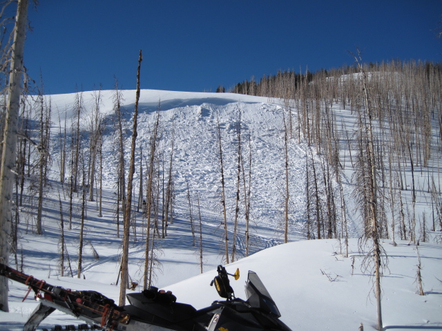
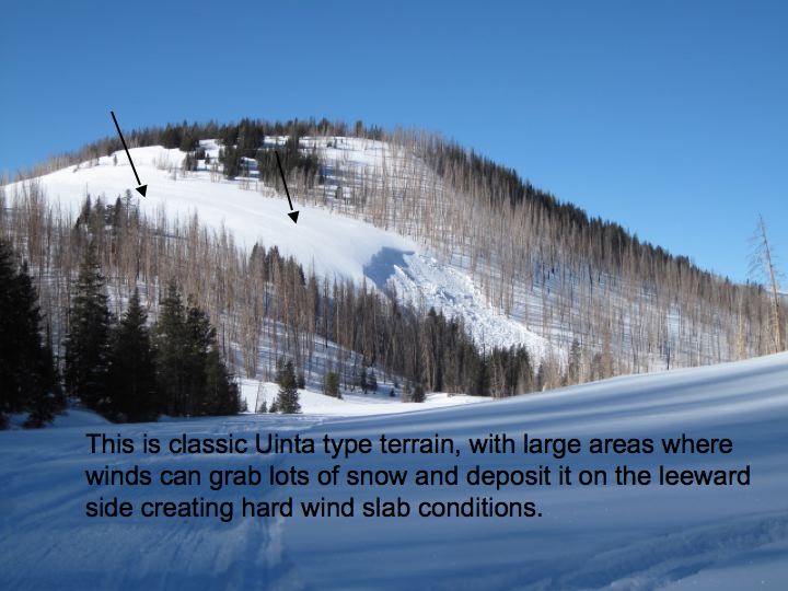
Ted was in Millcreek Friday and found this recently triggered slide on a steep northeast aspect, where strong southwest winds overloaded weak snow near the ground. Not a huge slide, but these hard slab avalanches can fracture very deep and pile up bone crushing blocks of snow. |
Avalanche Problem 1over the next 24 hours
| type | aspect/elevation | characteristics |
|---|
 |

Above treeline
Near treeline
Below treeline
|
|
|
description
This years riding conditions trump anything we saw last winter and lots of riders are getting into steep terrain without incident. Much of the terrain out there offers green light conditions, but our problem child- weak, sugary snow near the ground- still persists in steep, rocky terrain. Problem is... most of the snow feels strong and bomber, allowing us to get well out onto the slope before triggering a slide. The sky isn't falling, but if your travels take you into complex terrain today stop for a moment and carefully assess the snowpack and think about the consequences of triggering an avalanche. If you're not feelin' it, simply head to lower angle terrain where you can still have a blast carving in deep snow and not have to worry about avalanches.
.
|

Avalanche Problem 2over the next 24 hours
| type | aspect/elevation | characteristics |
|---|
 |
Above treeline
Near treeline
Below treeline
|
|
|
description
Both old and fresh wind drifts are found on steep leeward terrain facing the north half of the compass and now westerly facing slopes are getting in on the act. Fat looking, rounded pillows of snow, especially those sound hollow like a drum should be avoided.
|

 |
weather High clouds and continued mild temperatures with highs reaching into the low 30's are on tap for today. South and southwest winds will increase and should gust into the 40's late in the day. Another system grazes the state Monday night with a little light snow expected. Strong westerly winds ramp up midweek ahead of a cold and vigorous storm slated for Thursday. The computer models don't quite agree on how much snow we should see, but I should have a better idea for the midweek update.
|
| general annoucements Remember your information can save lives. If you see anything we should know about, please participate in the creation of our own community avalanche advisory by submitting snow and avalanche conditions. You can call me directly at 801-231-2170, email [email protected], or email by clicking HERE This is a great time of year to schedule a free avalanche awareness presentation for your group or club. You can contact me at 801-231-2170 or email [email protected] Donate to your favorite non-profit –The Friends of the Utah Avalanche Center. The UAC depends on contributions from users like you to support our work. The information in this advisory is from the US Forest Service which is solely responsible for its content. This advisory describes general avalanche conditions and local variations always occur. The information in this advisory expires 24 hours after the date and time posted, but will be updated by 7:00 AM Wednesday January 9th. |