

Avalanche Advisory
| Advisory: Uintas Area Mountains | Issued by Craig Gordon for December 23, 2012 - 5:23am |
|---|


Above treeline
Near treeline
Below treeline
|
bottom line Terrain to avoid- Upper elevation leeward slopes facing the north half of the compass The avalanche danger is CONSIDERABLE on steep wind loaded slopes, especially those facing East, North, Northeast and Northwest. Dangerous human triggered avalanches are likely. A MODERATE avalanche danger exists in mid elevation terrain and human triggered avalanches are possible on steep wind drifted slopes. LOW avalanche danger is found in low elevation, wind sheltered sheltered terrain.
|

 |
special announcement It's never too late to give that special someone (or yourself) an avalanche class for the holidays. A couple of clicks and you are done - no standing in line or shipping. Check out the Snowmobile Avalanche and Riding Skills Workshop... an avy class designed by riders for riders. Click here for more details. |
 |
current conditions Clouds and a few flurries drifted in the region overnight as a weak system slides through the area. Temperatures are in the low to mid 20's. Southwest winds bumped into the 50's yesterday afternoon, before mellowing out early this morning and are currently blowing 15-30 mph along the high peaks. Recent winds have damaged alot of our upper elevation terrain, though soft settled powder can still be found on low and mid elevation, wind sheltered, north facing slopes. Recent observations can be found here. Wondering why last winter was so crazy? Click here to watch the 2011-12 Utah Winter Review... an excellent recap of last years conditions. |
 |
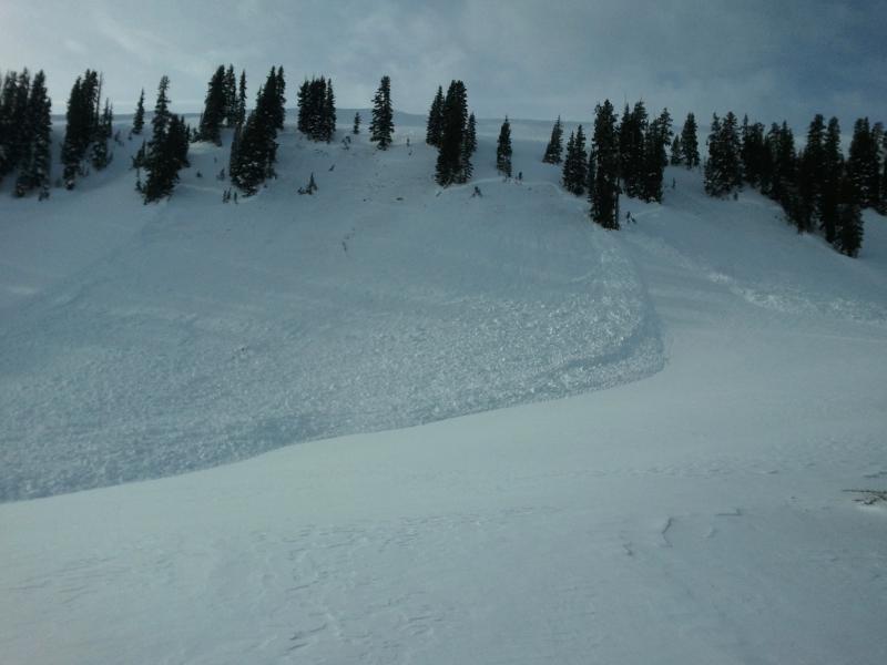
recent activity Booming collapses, remotely triggered slides breaking hundreds of feet wide and taking out the entire seasons snowpack.... it's been crazy on the eastern front the past few days! Many thanks to Ted Scroggin, Kam, JG, Deven, Matt and Devin, and the Park City Powdercats for all the great observations and for sharing critical information that can help save other riders lives.
This slide in Mill Hollow was triggered mid slope in terrain we normally go ride when avalanche danger is sketchy.
|

Avalanche Problem 1over the next 24 hours
| type | aspect/elevation | characteristics |
|---|
 |
Above treeline
Near treeline
Below treeline
|
|
|
description
Last weeks storm overloaded our midpack weaknesses and the region has seen its fair share of human triggered avalanches. Problem is... most slopes hang in the balance waiting for a trigger to come along and knock the legs out from under the slab. Steep, rocky terrain seems to be a common theme, but adding a dangerously tricky variable is the fact that you can trigger avalanches from low angle terrain and when you're mid slope. Once triggered, today's avalanches have the potential to break wide and deep, taking out the entire seasons snowpack, producing a very dangerous and possibly unsurvivable slide. Even if you're carving in low angle meadows make sure there's no steep slopes above or adjacent to where you're riding. . This slide in the Superbowl was triggered low on the slope and broke into old snow around the steep, rocky, windloaded break-over. Fortunately the rider came out unscathed and all is good. |

Avalanche Problem 2over the next 24 hours
| type | aspect/elevation | characteristics |
|---|
 |


Above treeline
Near treeline
Below treeline
|
|
|
description
Recent winds have helped complicate the avalanche danger and are forming yet another layer of slab to our already sketchy snowpack. Today you'll want to avoid steep slopes facing the north half of the compass, especially those with recent deposits of wind drifted snow. Avalanches triggered in the fresh wind drifts can easily break deeper and wider than you might expect. |
 |
weather A weakening weather system moves across the region this morning giving us a few scattered snow flurries and high temperatures in the mid to upper 20's. Southwest winds remain pretty mellow with averages in the teens and gusts in the 30's along the high ridges. A stronger and colder system moves into the region tonight, continuing through Monday night. The heaviest period of snow appears to be Monday morning into the early evening. This could be a good snow producer for the Uintas with a foot or so a good bet. |
| general annoucements Remember your information can save lives. If you see anything we should know about, please participate in the creation of our own community avalanche advisory by submitting snow and avalanche conditions. You can call me directly at 801-231-2170, email [email protected], or email by clicking HERE This is a great time of year to schedule a free avalanche awareness presentation for your group or club. You can contact me at 801-231-2170 or email [email protected] Donate to your favorite non-profit –The Friends of the Utah Avalanche Center. The UAC depends on contributions from users like you to support our work. The information in this advisory is from the US Forest Service which is solely responsible for its content. This advisory describes general avalanche conditions and local variations always occur. The information in this advisory expires 24 hours after the date and time posted, but will be updated by 7:00 AM Monday December 24th. |