SPECIAL ANNOUNCEMENT |
 |
Sunday, April 15th will be the last of our regularly scheduled advisories for the western Uinta's. |
|
|
BOTTOM LINE
Danger by aspect and elevation on slopes approaching 35° or steeper.
(click HERE for tomorrow's danger rating)
|
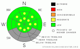
Danger Rose Tutorial
|
The avalanche danger is generally LOW this morning, but will be rising to MODERATE. As the snowpack heats up and especially as it becomes unsupportable, human triggered avalanches will be possible on all steep sun exposed slopes. |
|
|
CURRENT CONDITIONS |

|
A warm, dry southerly flow over the region has developed ahead of an active weather pattern slated to impact the region the next few days. In the mean time, skies are clear this morning, southwest winds are blowing 15-35 mph along the ridges, and temperatures are in the mid 40’s.
|
|
|
RECENT ACTIVITY |

|
No new avalanche activity to report.
Click here to view recent observations. |
|
|
THREAT #1 |

|
| WHERE |
PROBABILITY |
SIZE |
TREND |

|
|
|
|
| |
|
|
Over the next
24 hours.
|
|
|

Despite the overall lack of snow, we found surprisingly good riding conditions yesterday on a “go anywhere” supportable base.
In general the avalanche danger is LOW, but the lack of solid refreeze is a problem, especially on steep, rocky slopes that have remained thin all season. Once triggered, a wet slide can gouge into weak layers of snow near the ground, stacking up huge piles of cement-like debris. Wet avalanches are easy to avoid though. If the snow is getting wet, manky, and unsupportable, simply call it a day and move onto other activities. |
|
|
MOUNTAIN WEATHER |

|
Southerly winds will be cranking in the 50’s by day’s end and temperatures should soar into the mid and upper 50’s. A cold front moves into the area this evening, winds diminish, and the first wave of snow develops. Unsettled weather through Sunday should give us about a foot of snow. |
|
|
GENERAL ANNOUNCEMENTS |
The information in this advisory expires 24 hours after the date and time posted, but will be updated by 7:00 AM Saturday, April 14th.
If you’re getting out and about and trigger an avalanche or see anything interesting please drop me an email at
craig@utahavalanchecenter.org
or call 801-231-2170 |
|
|
This information does not apply to developed ski areas or highways where avalanche control is normally done. This advisory is from the U.S.D.A. Forest Service, which is solely responsible for its content. This advisory describes general avalanche conditions and local variations always occur. |
|
This advisory provided by the USDA Forest Service, in partnership with:
The Friends of the Utah Avalanche Center, Utah Division of State Parks and Recreation, Utah Division of Emergency Management, Salt Lake County, Salt Lake Unified Fire Authority and the friends of the La Sal Avalanche Center. See our Sponsors Page for a complete list. |
