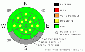
BOTTOM LINE
Danger by aspect and elevation on slopes approaching 35° or steeper.
(click HERE for tomorrow's danger rating)
|
Danger Rose Tutorial
|
The avalanche danger is generally LOW this morning and will rise to MODERATE on all steep slopes. Human triggered avalanches will be possible as the snowpack soaks in intense springtime sun. As the snow heats up, simply get off of and out from under steep slopes. |
|
|
CURRENT CONDITIONS |

|
A band of clouds slid into the region late yesterday, helping to keep overnight low temperatures in the mid 30’s. Winds are light and southerly, blowing 10-20 mph along the ridges. Sunday nights storm laid down 5-7” of new snow and was a nice little refresher. Overall, snow depths and coverage are pretty underwhelming, but once you get past sections of dry pavement and dirt, the riding and turning conditions are quite good on upper elevation north facing slopes.
|
|
|
RECENT ACTIVITY |

|
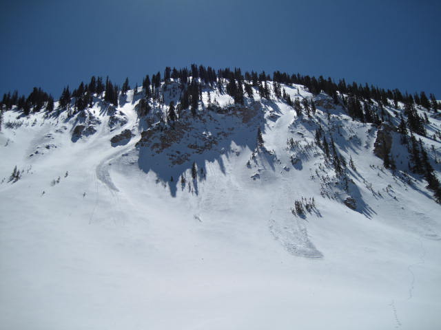
In the wake of the storm, manageable sluffs and soft slabs on steep upper elevation terrain were yesterday’s only avalanche issue.
Click here to view recent observations. |
|
|
THREAT #1 |

|
| WHERE |
PROBABILITY |
SIZE |
TREND |

|
|
|
|
| |
|
|
Over the next
24 hours.
|
|
|
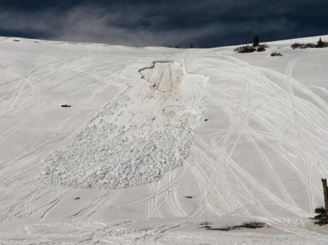
This wet slab was triggered late in the afternoon Saturday on the Manti-Skyline when three sledders were on the slope all at the same time. While about 100 miles away, we have a similar snowpack structure and these are the types of slides we can expect as temperatures start to rise.
In general the snowpack is well behaved and predictable. As the day heats up, the cold dry snow we’ve been riding the past few days will get damp and reactive to the strong spring time sun. These are manageable avalanche conditions and you can avoid wet sluffs today by getting off of steep slopes as the day heats up.
A bit more complex are deeper issues in our snowpack which could produce a wet slab that breaks to old snow near the ground. You know the drill by now… steep, rocky terrain that has remained shallow all winter and slopes that already slid this season remain suspect and could become more reactive to the weight of a rider, especially late in the day after the snowpack has absorbed the days heat. Once initiated, avalanches can break into weaker layers of snow resulting in a larger slide than you might’ve bargained for. As the day heats up, simply get off of and out from under steep slopes and avoid terrain traps like gullies and road cuts where huge piles of tree snapping debris can stack up deeply. |
|
|
MOUNTAIN WEATHER |

|
Clouds should start to move out of the area this morning, giving us a beautiful day. Increasing southerly winds usher in very warm conditions with temperatures soaring into the upper 40’s. Overnight lows dip into the upper 20’s. Winds increase further tonight into Thursday ahead of an approaching cold front which crosses the region late Thursday. Light snow is forecast to develop Thursday night and Friday, with accumulations in the 2”-4” range. High pressure builds for the weekend. |
|
|
GENERAL ANNOUNCEMENTS |
The information in this advisory expires 24 hours after the date and time posted, but will be updated by 7:00 AM Saturday, April 7th.
If you’re getting out and about and trigger an avalanche or see anything interesting please drop me an email at
craig@utahavalanchecenter.org
or call 801-231-2170 |
|
|
This information does not apply to developed ski areas or highways where avalanche control is normally done. This advisory is from the U.S.D.A. Forest Service, which is solely responsible for its content. This advisory describes general avalanche conditions and local variations always occur. |
|
This advisory provided by the USDA Forest Service, in partnership with:
The Friends of the Utah Avalanche Center, Utah Division of State Parks and Recreation, Utah Division of Emergency Management, Salt Lake County, Salt Lake Unified Fire Authority and the friends of the La Sal Avalanche Center. See our Sponsors Page for a complete list. |
