BOTTOM LINE
Danger by aspect and elevation on slopes approaching 35° or steeper.
(click HERE for tomorrow's danger rating)
|
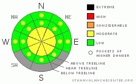
Danger Rose Tutorial
|
The danger of wet sluffs and wet slabs will start out as a Level 1(LOW) this morning, rising to Level 2 (MODERATE) later in the day as the snowpack soaks up the days heat. Deep, dangerous human triggered avalanches are possible, especially on steep slopes with a thin, punchy feeling snowpack. |
|
|
CURRENT CONDITIONS |

|
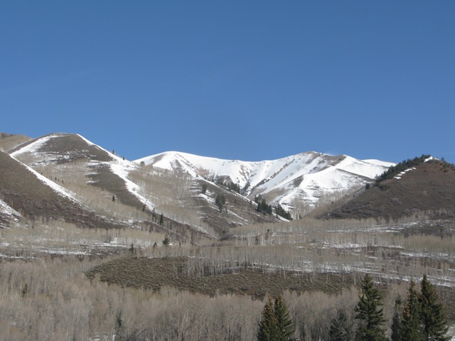
Nearly all low elevation south facing terrain is done for the season
Skies are clear and southerly winds are blowing 20-40 mph along the ridges ahead of a Pacific storm slated to impact the region late tonight. Overnight low temperatures only got down into the upper 30’s at most locations. Trial Lake is reporting 30 degrees. Despite the warm temperatures and big melt down, supportable snow conditions exist on mid and upper elevation south aspects. On the other side of the compass, shallow creamy powder will be found on high elevation northerly facing terrain.
|
|
|
RECENT ACTIVITY |

|
No new avalanche activity to report.
Click here to view recent observations. |
|
|
THREAT #1 |

|
| WHERE |
PROBABILITY |
SIZE |
TREND |

|
|
|
|
| |
|
|
Over the next
24 hours.
|
|
|
Man… the snowpack has taken a big hit the past week and it’s going fast! Several nights of marginal refreezes and record breaking temperatures today will add insult to injury. The surface snow will get damp and manky, but I'm more concerned with the weak, sugary layers of snow near the base of our snowpack which will get irritated with the heat wave. Steep, rocky terrain that has remained shallow all winter and slopes that already slid this season remain suspect and could become more reactive to the weight of a rider, especially late in the day after the snowpack has absorbed the days heat. Once initiated, avalanches can break into weaker layers of snow resulting in a larger slide than you might’ve bargained for. As the day heats up, simply get off of and out from under steep slopes and avoid terrain traps like gullies and road cuts where huge piles of bone snapping debris can stack up deeply. |
|
|
MOUNTAIN WEATHER |

|
Under sunny skies, southerly winds continue to crank throughout the day, gusting into the 50’s and 60’s along the ridges. Temperatures soar into record breaking territory, reaching into the mid and upper 50’s. Winds diminish behind the cold front early Sunday morning and temperatures crash into the low 20’s. Snow accumulations are underwhelming…. I’m thinking 4” or so by Sunday afternoon. High pressure builds for the early part of next week. |
|
|
GENERAL ANNOUNCEMENTS |
The information in this advisory expires 24 hours after the date and time posted, but will be updated by 7:00 AM Sunday, April1st.
If you’re getting out and about and trigger an avalanche or see anything interesting please drop me an email at
craig@utahavalanchecenter.org
or call 801-231-2170 |
|
|
This information does not apply to developed ski areas or highways where avalanche control is normally done. This advisory is from the U.S.D.A. Forest Service, which is solely responsible for its content. This advisory describes general avalanche conditions and local variations always occur. |
|
This advisory provided by the USDA Forest Service, in partnership with:
The Friends of the Utah Avalanche Center, Utah Division of State Parks and Recreation, Utah Division of Emergency Management, Salt Lake County, Salt Lake Unified Fire Authority and the friends of the La Sal Avalanche Center. See our Sponsors Page for a complete list. |
