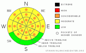
BOTTOM LINE
Danger by aspect and elevation on slopes approaching 35° or steeper.
(click HERE for tomorrow's danger rating)
|
Danger Rose Tutorial
|
The danger of wet avalanches will rise from Level 2 (MODERATE) to Level 3 (CONSIDERABLE) on all steep slopes and human triggered avalanches are probable during the heat of the day. |
|
|
CURRENT CONDITIONS |

|
The winter that wasn't. Riding and turning conditions are less than ideal and the snowpack has taken a hard hit this week.
It's a bit underwhelming out there this morning. Skies are mostly cloudy, southerly winds blowing 30-60 mph along the ridges, and temperatures barely froze overnight with lows only reaching into the low to mid 30’s. |
|
|
RECENT ACTIVITY |

|
No new avalanche activity to report.
Click here to view recent observations. |
|
|
THREAT #1 |

|
| WHERE |
PROBABILITY |
SIZE |
TREND |

|
|
|
|
| |
|
|
Over the next
24 hours.
|
|
|

Steep, rocky terrain with a thin snowpack like the steep chutes on Bald Mountain would be likely terrain where you could trigger a wet slab that breaks to weak snow near the ground.
Avalanche conditions will be changing in the next 24 hours as a cold Pacific system moves through the region. With a marginal refreeze overnight, today’s main avalanche concern revolves around triggering wet slabs and sluffs. The combination of clouds and wind may help to keep wet avalanche activity at bay, however low elevation terrain and all steep slopes that have a thin, weak snowpack remain suspect and should be avoided. Once initiated, avalanches can break into weaker layers of snow resulting in a larger slide than you might’ve bargained for. As the day heats up, simply get off of and out from under steep slopes and avoid terrain traps like gullies and road cuts where huge piles of bone snapping debris can stack up deeply. |
|
|
MOUNTAIN WEATHER |

|
A warm, windy, and cloudy day is on tap for the region. Temperatures climb into the mid 40’s and southerly winds crank into the 60’s and 70’s, especially late in the day. The storm arrives tonight and the Uinta’s should do well with about a foot of snow accumulating by Sunday afternoon. Snow showers linger through Monday with more winter-like temperatures expected. |
|
|
GENERAL ANNOUNCEMENTS |
The information in this advisory expires 24 hours after the date and time posted, but will be updated by 7:00 AM Sunday, March 18th.
If you’re getting out and about and trigger an avalanche or see anything interesting please drop me an email at
craig@utahavalanchecenter.org
or call 801-231-2170 |
|
|
This information does not apply to developed ski areas or highways where avalanche control is normally done. This advisory is from the U.S.D.A. Forest Service, which is solely responsible for its content. This advisory describes general avalanche conditions and local variations always occur. |
|
This advisory provided by the USDA Forest Service, in partnership with:
The Friends of the Utah Avalanche Center, Utah Division of State Parks and Recreation, Utah Division of Emergency Management, Salt Lake County, Salt Lake Unified Fire Authority and the friends of the La Sal Avalanche Center. See our Sponsors Page for a complete list. |
