SPECIAL ANNOUNCEMENT |
 |
A few openings are still available in our 4th annual Avy Essential Skills Workshop geared specifically for sledders on the evening of Thursday March 15th followed by an on-the-snow field day Saturday March 17th. Click here for more info and to register. |
|
|
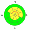
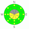
BOTTOM LINE
Danger by aspect and elevation on slopes approaching 35° or steeper.
(click HERE for tomorrow's danger rating)
|
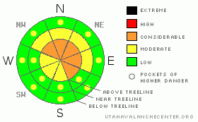
Danger Rose Tutorial
|
In the wind zone in upper elevation terrain, pockets of Level 3 (CONSIDERABLE) avalanche danger exist on steep wind drifted, shady slopes and human triggered avalanches are probable.
The danger of wet avalanches will rise from Level 1 (LOW) this morning to Level 2 (MODERATE) on all steep sunny slopes and human triggered avalanches are possible during the heat of the day. |
|
|
CURRENT CONDITIONS |

|
Skies are clear and a mild southwest flow over the region kept overnight lows in the mid 20's. Winds are light and variable, blowing less than 15 mph along the ridges. Most of the sunny slopes are crusted, but soft settled powder can still be found on upper elevation north facing terrain. |
|
|
RECENT ACTIVITY |

|
On Friday morning, Ted spotted a snowmobile triggered hard slab on Yamaha Hill. Averaging 2' deep and 150' wide, this slide broke on weak snow which developed during the dry spell prior to the big mid week storm two weeks ago.
Click here to view recent observations. |
|
|
THREAT #1 |

|
| WHERE |
PROBABILITY |
SIZE |
TREND |
|
|
|
|
| |
|
|
Over the next
24 hours.
|
|
|
The surface snow is strong and allows for great climbing and steeper ascents. However, slabs breaking several feet deep still haunt the range, particularly on steep, northerly facing slopes at upper elevations. Rather than blindly center-punching your favorite bowl or chute, gather some information by tweaking small test slopes similar in aspect, elevation, and slope angle and see how they're reacting before commiting to a steep line. |
|
|
THREAT #2 |

|
| WHERE |
PROBABILITY |
SIZE |
TREND |
|
|
|
|
| |
|
|
Over the next
24 hours.
|
|
|
Wet avalanches are more straight-forward and easy to avoid. Simply get off of and out from under steep slopes during the heat of the day. In addition, carefully plan your exit strategy so you're not at the bottom of a gully or terrain trap where huge piles of bone crushing debris can bury you very deeply. |
|
|
THREAT #3 |

|
| WHERE |
PROBABILITY |
SIZE |
TREND |

|
|
|
|
| |
|
|
Over the next
24 hours.
|
|
|
Cornices are huge and breaking back further than you might think. |
|
|
MOUNTAIN WEATHER |

|
Today we can expect partly cloudy skies, warm tempratures, and southwest winds gusting into the 30's and 40's along the high ridges. It'll be a mild day with temperatures climbing into the low 40's. Overnight lows dip into the mid 20's. Not much going on in the weather department until late in the week when the next cold front is expected to produce more winter-like weather. |
|
|
GENERAL ANNOUNCEMENTS |
The information in this advisory expires 24 hours after the date and time posted, but will be updated by 7:00 AM Wednesday, March 14th.
If you’re getting out and about and trigger an avalanche or see anything interesting please drop me an email at
craig@utahavalanchecenter.org
or call 801-231-2170 |
|
|
This information does not apply to developed ski areas or highways where avalanche control is normally done. This advisory is from the U.S.D.A. Forest Service, which is solely responsible for its content. This advisory describes general avalanche conditions and local variations always occur. |
|
This advisory provided by the USDA Forest Service, in partnership with:
The Friends of the Utah Avalanche Center, Utah Division of State Parks and Recreation, Utah Division of Emergency Management, Salt Lake County, Salt Lake Unified Fire Authority and the friends of the La Sal Avalanche Center. See our Sponsors Page for a complete list. |
