SPECIAL ANNOUNCEMENT |
 |
Continued warm temperatures and strong sunshine will create dangerous avalanche conditions in the western Uinta Mountains. Human triggered avalanches are likely on all steep slopes. |
|
|
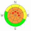
BOTTOM LINE
Danger by aspect and elevation on slopes approaching 35° or steeper.
(click HERE for tomorrow's danger rating)
|

Danger Rose Tutorial
|
Overall the avalanche danger is a Level 3 (CONSIDERABLE). Human triggered dry and wet snow avalanches are probable on steep slopes during the heat of the day.
The danger of wet avalanches at lower elevations will rise from Level 1 (LOW) this morning to Level 2 (MODERATE) and human triggered avalanches will be possible with daytime heating. |
|
|
CURRENT CONDITIONS |

|
Under clear skies temperatures are in the mid 20's and southwest winds are blowing 15-25 mph along the ridges. |
|
|
RECENT ACTIVITY |

|

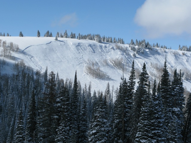
This slide near Co-op Creek broke to the ground in places, partially burying one sledder.
Sunday was very active with one complete 20 minute burial near Hoyt Peak and a partial burial near Co-op.
Click here to view recent observations. |
|
|
THREAT #1 |

|
| WHERE |
PROBABILITY |
SIZE |
TREND |
|
|
|
|
| |
|
|
Over the next
24 hours.
|
|
|
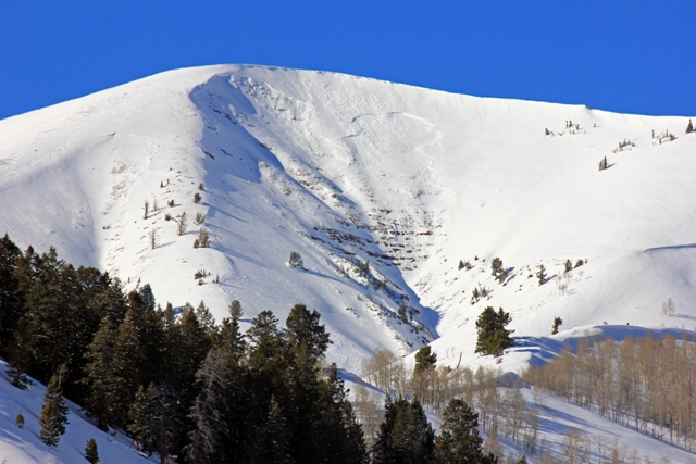
This is an interesting natural avalanche which broke 2'-3' deep and 1000' wide above the Mill Hollow Reservoir. Click here to view a viddy on snowpack conditions and structure.
Continued warm temperatures may help to activate weak layers of snow, now buried several feet deep, and that will allow slabs to become more reactive.Staying off of and out from under steep slopes during the heat of the day is going to be the ticket. |
|
|
THREAT #2 |

|
| WHERE |
PROBABILITY |
SIZE |
TREND |

|
|
|
|
| |
|
|
Over the next
24 hours.
|
|
|
In addition to steep south facing slopes, all but the highest elevation north facing terrain will get baked by the sun today. Remember- wet avalanches can channel tremendous amounts of snow into terrain traps like gullies and road cuts, stacking up huge piles of bone snapping debris. Carefully plan your route back to the rig so you won’t have to deal with any questionable slopes above or adjacent to your exit. |
|
|
MOUNTAIN WEATHER |

|
Mostly sunny skies with highs reaching into the mid 40's and southwest winds increasing ahead of a weak system slated to brush-by the region Tuesday night. 3"-6" of snow is expected by Wednesday before high pressure and warm temperatures return. |
|
|
GENERAL ANNOUNCEMENTS |
The information in this advisory expires 24 hours after the date and time posted, but will be updated by 7:00 AM Wednesday, March 7th.
If you’re getting out and about and trigger an avalanche or see anything interesting please drop me an email at
craig@utahavalanchecenter.org
or call 801-231-2170 |
|
|
This information does not apply to developed ski areas or highways where avalanche control is normally done. This advisory is from the U.S.D.A. Forest Service, which is solely responsible for its content. This advisory describes general avalanche conditions and local variations always occur. |
|
This advisory provided by the USDA Forest Service, in partnership with:
The Friends of the Utah Avalanche Center, Utah Division of State Parks and Recreation, Utah Division of Emergency Management, Salt Lake County, Salt Lake Unified Fire Authority and the friends of the La Sal Avalanche Center. See our Sponsors Page for a complete list. |
