AVALANCHE WARNING »
Dangerous avalanche conditions are occuring or are imminent.
Backcountry travel in avalanche terrain is not recommended.
|
 |
Notice: THIS AVALANCHE WARNING IS FOR THE MOUNTAINS OF NORTHERN AND CENTRAL UTAH, TO INCLUDE THE BEAR RIVER RANGE, THE WESTERN UINTAS AND THE WASATCH PLATEAU. RAPID WARMING AND DIRECT SUN WILL CREATE DANGEROUS AND UNSTABLE AVALANCHE CONDITIONS. NATURAL AND HUMAN TRIGGERED AVALANCHES ARE LIKELY. BACKCOUNTRY TRAVEL ON OR BELOW STEEP MOUNTAIN SLOPES IS NOT RECOMMENDED OVER THE NEXT FEW DAYS. |
|
|
SPECIAL ANNOUNCEMENT |
 |
Yesterday, a group of snowmobilers triggered a large avalanche in Beaver Basin, in the La Sal Mountains near Moab. One member of the group is still missing and a search to find the buried sledder will resume today. We’ll have more details as they unfold. Our thoughts and prayers go out to all involved. |
|
|
BOTTOM LINE
Danger by aspect and elevation on slopes approaching 35° or steeper.
(click HERE for tomorrow's danger rating)
|
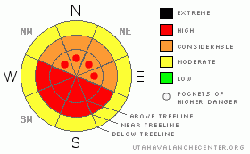
Danger Rose Tutorial
|
The avalanche danger on steep sunny slopes will rise to Level 4 (HIGH) and both human triggered and natural avalanches are likely during the heat of the day.
On shady slopes a Level 3 (CONSIDERABLE) danger exists and human triggered avalanches breaking on a variety of buried weak layers are probable.
The danger of wet avalanches at lower elevations will rise from Level 1 (LOW) this morning to Level 2 (MODERATE) and human triggered avalanches will be possible with daytime heating. |
|
|
CURRENT CONDITIONS |

|
A few rogue clouds are drifting through the region as high pressure begins to build. Temperatures are balmy, in the low to mid 20’s and winds are light and variable blowing 5-15 mph. South facing slopes took on a bit of heat yesterday, but shady slopes remain soft and creamy. |
|
|
RECENT ACTIVITY |

|
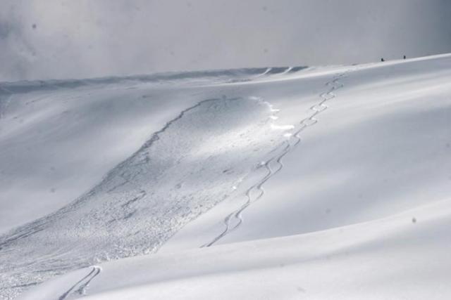
On Friday, a skier remotely triggered an avalanche on an upper elevation southeast facing slope in upper Weber Canyon. Breaking 2.5 ft. deep and about 80’ wide the slide ran close to 400’ vertically.
Remotely triggered avalanches continue to be the theme, particularly on east and southeast facing slopes. Yesterday, several slides were reported around Strawberry and one near Coop Creek. Averaging 2.5’-3’ deep, the slides are breaking up to 200’ wide and stacking up huge piles of debris.
Click here to view recent observations. |
|
|
THREAT #1 |

|
| WHERE |
PROBABILITY |
SIZE |
TREND |
|
|
|
|
| |
|
|
Over the next
24 hours.
|
|
|
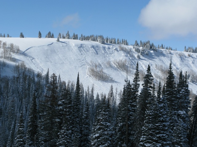
This is an interesting natural avalanche which broke 2'-3' deep and 1000' wide above the Mill Hollow Reservoir. Click here to view a viddy on snowpack conditions and structure.
The recent storm snow will experience a one-two punch today and tomorrow. First, the southerly aspects will get a taste of strong springtime sun today and that’s definitely going to make it cranky. In addition, we expect rising temperatures and even the shady slopes will get in on the act. The combination may help to activate weak layers of snow, now buried several feet deep, and that will allow slabs to become more reactive.Staying off of and out from under steep slopes during the heat of the day is going to be the ticket. |
|
|
THREAT #2 |

|
| WHERE |
PROBABILITY |
SIZE |
TREND |

|
|
|
|
| |
|
|
Over the next
24 hours.
|
|
|
In addition to steep south facing slopes, mid and lower elevation shady terrain will get baked by the sun today. Remember- wet avalanches can channel tremendous amounts of snow into terrain traps like gullies and road cuts, stacking up huge piles of bone snapping debris. Carefully plan your route back to the rig so you won’t have to deal with any questionable slopes above or adjacent to your exit. |
|
|
MOUNTAIN WEATHER |

|
Warm and dry conditions develop today and Monday. Light winds, sunny skies, and high temperatures slated to soar in to the upper 30’s are a good bet. Lows dip into the upper teens. The next storm system should arrive Tuesday afternoon. |
|
|
GENERAL ANNOUNCEMENTS |
The information in this advisory expires 24 hours after the date and time posted, but will be updated by 7:00 AM Wednesday, March 7th.
If you’re getting out and about and trigger an avalanche or see anything interesting please drop me an email at
craig@utahavalanchecenter.org
or call 801-231-2170 |
|
|
This information does not apply to developed ski areas or highways where avalanche control is normally done. This advisory is from the U.S.D.A. Forest Service, which is solely responsible for its content. This advisory describes general avalanche conditions and local variations always occur. |
|
This advisory provided by the USDA Forest Service, in partnership with:
The Friends of the Utah Avalanche Center, Utah Division of State Parks and Recreation, Utah Division of Emergency Management, Salt Lake County, Salt Lake Unified Fire Authority and the friends of the La Sal Avalanche Center. See our Sponsors Page for a complete list. |
