AVALANCHE WARNING »
Dangerous avalanche conditions are occuring or are imminent.
Backcountry travel in avalanche terrain is not recommended.
|
 |
Notice: An Avalanche Warning remains in effect for the western Uinta Mountains. Strong winds and recent snowfall have created a HIGH avalanche danger. Deep, dangerous human triggered avalanches are likely. People should stay off of and out from under steep wind drifted terrain. |
|
|
SPECIAL ANNOUNCEMENT |
 |
Looking for a safe way to ride Utah's powder during High backcountry avy danger? Click here for discounted lift tickets provided through a great partnership with local ski resorts and Ski Utah. |
|
|
BOTTOM LINE
Danger by aspect and elevation on slopes approaching 35° or steeper.
(click HERE for tomorrow's danger rating)
|
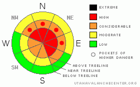
Danger Rose Tutorial
|
In the wind zone at upper elevations a Level 4 (HIGH) avalanche danger exists for both fresh wind drifts and for avalanches which can break into a variety of weak layers. Human triggered avalanches are likely on steep wind drifted slopes, especially those with an easterly component to their aspect.
At mid elevations, human triggered avalanches are probable and a Level 3 (CONSIDERABLE) danger will be found on all steep wind drifted slopes.
Winds even got into low elevation terrain, loading slopes facing the north half of the compass. A Level 2 (MODERATE) danger exists on steep slopes with recent deposits of wind drifted snow and human triggered avalanches are possible. |
|
|
CURRENT CONDITIONS |

|
Wow…. what a good storm for the eastern front. After a day of nuking winds, the front rolled through, dumped a foot of snow overnight and this morning we have a short-lived break. Temperatures are in the single digits and winds are light and variable, blowing 5-15 mph along the ridges. |
|
|
RECENT ACTIVITY |

|
Steep upper elevation terrain came unglued yesterday around midday. Natural avalanches 2’-3’ deep were reported throughout the region.
Click here to view recent observations. |
|
|
THREAT #2 |

|
| WHERE |
PROBABILITY |
SIZE |
TREND |
|
|
|
|
| |
|
|
Over the next
24 hours.
|
|
|
Yesterday’s west and southwest winds raged along the upper elevations, overloading a weak layer of near surface facets and surface hoar formed during a clear, cold spell on February 7th. (Click here for a recap of Tuesday's field day). This was the culprit weak layer that led to at least a half dozen human triggered slides on Friday and we believe much of yesterday's activity broke to this weak layer. Strong winds and additional new snow load the next few days will continue to irritate this weak layer. Human triggered avalanches will be deeper and break wider than you might expect. |
|
|
THREAT #3 |

|
| WHERE |
PROBABILITY |
SIZE |
TREND |
|
|
|
|
| |
|
|
Over the next
24 hours.
|
|
|
Snow and water totals are starting to stack up and deep, dangerous avalanches that break to weak snow near the ground, aren't out of the question. Steep, rocky, upper elevation, north facing terrain where a thin, weak snowpack is connected to strong snow or terrain that avalanched near the ground in mid January are likely suspects. |
|
|
MOUNTAIN WEATHER |

|
A moist and unstable westerly flow homesteads over the region today bringing periods of snow with temperatures remaining in the teens throughout the day. West and southwest winds bump up slightly into the 20-40 mph range, and then switch to the northwest and increase as a colder wave crosses the region this evening, bringing another round of heavy snow. A foot of snow is a good bet with overnight lows crashing into negative territory. Light snow showers are expected Friday and early Saturday. |
|
|
GENERAL ANNOUNCEMENTS |
The information in this advisory expires 24 hours after the date and time posted, but will be updated by 7:00 AM Friday, March 2nd.
If you’re getting out and about and trigger an avalanche or see anything interesting please drop me an email at
craig@utahavalanchecenter.org
or call 801-231-2170 |
|
|
This information does not apply to developed ski areas or highways where avalanche control is normally done. This advisory is from the U.S.D.A. Forest Service, which is solely responsible for its content. This advisory describes general avalanche conditions and local variations always occur. |
|
This advisory provided by the USDA Forest Service, in partnership with:
The Friends of the Utah Avalanche Center, Utah Division of State Parks and Recreation, Utah Division of Emergency Management, Salt Lake County, Salt Lake Unified Fire Authority and the friends of the La Sal Avalanche Center. See our Sponsors Page for a complete list. |
